
File:Aeolis Mensae Yardangs.JPG
此为最大尺寸。
Aeolis_Mensae_Yardangs.JPG (620 × 464像素,文件大小:74 KB,MIME类型:image/jpeg)

|
此文件是通过机器人脚本从en.wikipedia移动到维基共享资源的。来源中的所有信息均已保留,但仍需要人工的审阅。部分或所有的信息可能会出现在错误的区域;只有在经过审阅并修正需改正的错误后,此文件的相关信息才能视为可使用。当审阅结束后,请移除本模板,更详细的信息参见下方。 现在就开始检查! |
摘要
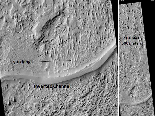
| 描述 | Aeolis Mensae Yardangs and inverted channel, as seen by hirise. Location is 6.3 degrees south latitude and 151.1 degrees east longitude. Image was taken by the Mars Reconnaissance Orbiter's HiRISE. The HiRISE camera was built by Ball Aerospace and Technology Corporation and is operated by the University of Arizona. Image courtesy NASA/JPL/University of Arizona. |
| 日期 | |
| 来源 | http://hirise.lpl.arizona.edu/PSP_009966_1735 |
| 作者 | Jim Secosky modified nasa image. |
许可协议
| 本文件完全由NASA创作,在美国属于公有领域。根据NASA的版权方针,NASA的材料除非另有声明否则不受版权保护。(参见Template:PD-USGov/zh、NASA版权方针页面或JPL图片使用方针。) | ||
 |
警告:
|
文件历史
点击某个日期/时间查看对应时刻的文件。
| 日期/时间 | 缩略图 | 大小 | 用户 | 备注 | |
|---|---|---|---|---|---|
| 当前 | 2010年3月21日 (日) 04:35 | | 620 × 464(74 KB) | Ohms Law Bot | {{BotMoveToCommons|1=en.wikipedia|day=21|month=March|year=2010}} == Summary == {{Information |Description = Aeolis Mensae Yardangs and inverted channel, as seen by hirise. Location is 6.3 degrees south latitude and 151.1 degrees east longitude. Ima |
文件用途
以下页面使用本文件:
全域文件用途
以下其他wiki使用此文件:
- en-two.iwiki.icu上的用途
- fr.wikipedia.org上的用途
- pt.wikipedia.org上的用途
- uk.wikipedia.org上的用途