
File:Arabic Varieties Map.svg

原始文件 (SVG文件,尺寸为2,051 × 1,151像素,文件大小:2.08 MB)

|
本文件已被Arabic Varieties Map-2023.svg取代。建议您使用其他文件。请注意,删除被取代的图片需要达成一致。
|

|

| 註解 | 該圖片含有註解:在維基媒體共享資源上查看註解 |
摘要
| 描述 |
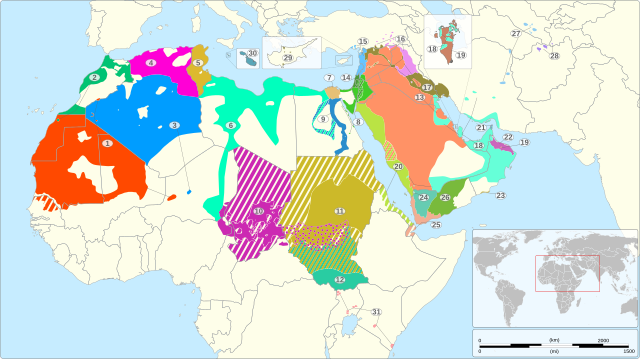
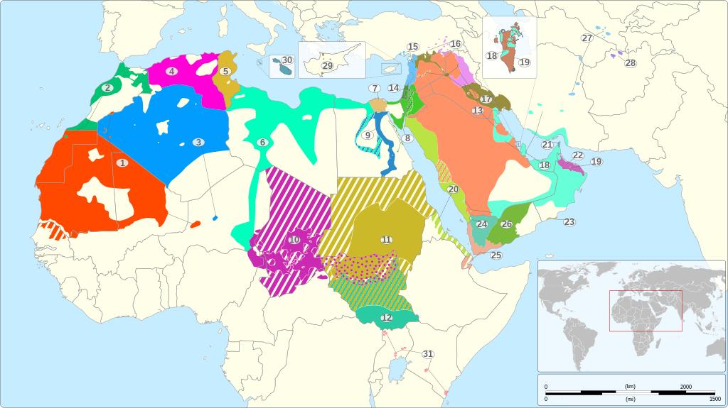
English: Map of the geographical distribution of the various varieties of Arabic recognized as languages by the ISO 639-3 standard, including Arabic-based creoles but excluding Judeo-Arabic languages.
1: Hassaniyya (mey) #00c373 #009dff #ff00d6 #ddb92f #00ffbd #e7c075 #51cc29 #298dcc #cc29b2 #ccb929 #29cca2 #ff9266 #4b993d #66c4ff #ea93f0 #998e3d #66ffd8 #cc8366 #bae344 #66a5cc #cc66bc #ccc066 #66ccb2 #f2ae92 #79ba3c #91cdf2 #a786f2 #a4a068 #59a6b8 #fc7183 #fefee9ff #cc29b2 #cc29b2 6px #cc29b2 dotted Dotted
|
|||
| 日期 | ||||
| 来源 |
基于如下对象的个人作品: 个人作品,使用: OSM References:
|
|||
| 作者 | Goran_tek-en | |||
| 授权 (二次使用本文件) |
本文件采用知识共享署名-相同方式共享 4.0 国际许可协议授权。 署名: Goran_tek-en
|
|||
| 其他版本 |
|
|||
| SVG开发 |


| 物体位置 | | 在以下服务上查看本图像和附近其他图像: OpenStreetMap |
|---|


.gif)
文件历史
点击某个日期/时间查看对应时刻的文件。
| 日期/时间 | 缩略图 | 大小 | 用户 | 备注 | |
|---|---|---|---|---|---|
| 当前 | 2022年11月20日 (日) 12:19 | | 2,051 × 1,151(2.08 MB) | Goran tek-en | Edited 13/20 pattern as requested by A455bcd9 |
| 2022年11月14日 (一) 11:44 |  | 2,051 × 1,151(1.99 MB) | Goran tek-en | Bahrain edited as requested by A455bcd9 | |
| 2022年11月7日 (一) 18:18 |  | 2,051 × 1,151(1.96 MB) | Goran tek-en | {{Information |description ={{en|Map of the geographical distribution of the various varieties of Arabic recognized by the ISO 639-3 standard, including Arabic-based creoles but excluding Judeo-Arabic languages.}}<br> {| class="wikitable" |- | width = "30px" bgcolor = "#ff4900" | ||style=text-align:right| 1 || width = "250px" | Hassaniyya (mey) || w... |
文件用途
全域文件用途
以下其他wiki使用此文件:
- ab.wikipedia.org上的用途
- af.wikipedia.org上的用途
- ar.wikipedia.org上的用途
- ar.wikiquote.org上的用途
- arz.wikipedia.org上的用途
- ast.wikipedia.org上的用途
- as.wikipedia.org上的用途
- av.wikipedia.org上的用途
- azb.wikipedia.org上的用途
- az.wikipedia.org上的用途
- bat-smg.wikipedia.org上的用途
- ba.wikipedia.org上的用途
- bg.wikipedia.org上的用途
- bh.wikipedia.org上的用途
- br.wikipedia.org上的用途
- bs.wikipedia.org上的用途
- ca.wikipedia.org上的用途
- ceb.wikipedia.org上的用途
- chy.wikipedia.org上的用途
- cs.wikipedia.org上的用途
- cy.wikipedia.org上的用途
- de.wikipedia.org上的用途
- de.wikivoyage.org上的用途
- el.wikipedia.org上的用途
- eml.wikipedia.org上的用途
- en-two.iwiki.icu上的用途
查看本文件的更多全域用途。