
File:Caledonides EN.svg

此SVG文件的PNG预览的大小:630 × 421像素。 其他分辨率:320 × 214像素 | 640 × 428像素 | 1,024 × 684像素 | 1,280 × 855像素 | 2,560 × 1,711像素。
原始文件 (SVG文件,尺寸为630 × 421像素,文件大小:126 KB)
摘要
| 描述 |
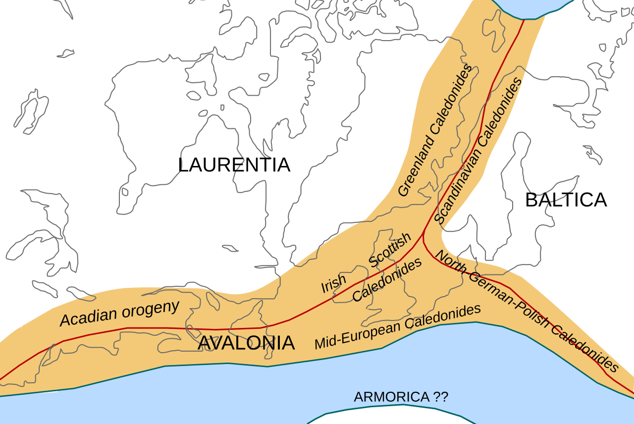
English: Location of the Caledonian/Acadian mountain chains in the Early Devonian Epoch. Present day coastlines are shown for reference. Red lines are sutures, capitalized names are the different continents/super-terranes that joined during the Caledonian orogeny. See en:Avalonia, en:Baltica, en:Laurentia.
Literature used to make this map:
|
| 日期 | |
| 来源 | 自己的作品 |
| 作者 | Woudloper |
| 其他版本 |
此文件衍生的作品: |

|
此SVG檔案包含可翻譯至您的語言的内嵌文字,可以使用任何可用SVG編輯器、文本編輯器或SVG翻譯工具來翻譯。詳情請見:關於翻譯SVG檔案。 |
W3C-validity not checked.
许可协议
本文件采用知识共享署名-相同方式共享 1.0 通用许可协议授权。
- 您可以自由地:
- 共享 – 复制、发行并传播本作品
- 修改 – 改编作品
- 惟须遵守下列条件:
- 署名 – 您必须对作品进行署名,提供授权条款的链接,并说明是否对原始内容进行了更改。您可以用任何合理的方式来署名,但不得以任何方式表明许可人认可您或您的使用。
- 相同方式共享 – If you alter, transform, or build upon this work, you must distribute the resulting work under the same license as the original.
文件历史
点击某个日期/时间查看对应时刻的文件。
| 日期/时间 | 缩略图 | 大小 | 用户 | 备注 | |
|---|---|---|---|---|---|
| 当前 | 2008年10月28日 (二) 10:45 | | 630 × 421(126 KB) | Woudloper | == Beschreibung == {{Information |Description={{en|1=Location of the Caledonian/Acadian mountain chains in the Early Devonian Epoch. Present day coastlines are shown for reference. Red lines are sutures, capitalized names are the different continents/supe |
| 2008年10月23日 (四) 09:50 |  | 630 × 421(132 KB) | Woudloper | == Beschreibung == {{Information |Description={{en|1=Location of the Caledonian/Acadian mountain chains in the Early Devonian Epoch. Present day coastlines are shown for reference. Red lines are sutures, capitalized names are the different continents/supe | |
| 2008年10月21日 (二) 15:17 |  | 630 × 421(132 KB) | Woudloper | {{Information |Description={{en|1=Location of the Caledonian/Acadian mountain chains in the Early Devonian Epoch. Present day coastlines are shown for reference. Red lines are sutures, capitalized names are the different continents/super-terranes that joi |
文件用途
以下2个页面使用本文件:
全域文件用途
以下其他wiki使用此文件:
- az.wikipedia.org上的用途
- be-tarask.wikipedia.org上的用途
- be.wikipedia.org上的用途
- bg.wikipedia.org上的用途
- ca.wikipedia.org上的用途
- da.wikipedia.org上的用途
- en-two.iwiki.icu上的用途
- fa.wikipedia.org上的用途
- fr.wikipedia.org上的用途
- gl.wikipedia.org上的用途
- hy.wikipedia.org上的用途
- id.wikipedia.org上的用途
- it.wikipedia.org上的用途
- ja-two.iwiki.icu上的用途
- lv.wikipedia.org上的用途
- mk.wikipedia.org上的用途
- nl.wikipedia.org上的用途
- nn.wikipedia.org上的用途
- no.wikipedia.org上的用途
- pl.wikipedia.org上的用途
- ro.wikipedia.org上的用途
- ru.wikipedia.org上的用途
- simple.wikipedia.org上的用途
- sl.wikipedia.org上的用途
- tr.wikipedia.org上的用途
- uk.wikipedia.org上的用途
- vi.wikipedia.org上的用途