
File:ChiosPrefecture.jpg

本预览的尺寸:800 × 580像素。 其他分辨率:320 × 232像素 | 640 × 464像素 | 1,024 × 743像素 | 1,278 × 927像素。
原始文件 (1,278 × 927像素,文件大小:109 KB,MIME类型:image/jpeg)
| 描述 |
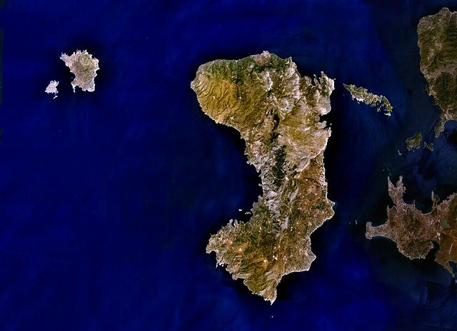
English: Public Domain composite satellite image of Chios Prefecture; consisting of the islands of Chios (centre), of Psara and Anti-Psara (West and far west), the Oinousses islands (East of Chios). Also includes Turkish mainland (East-shaded).
Source: NASA World Wind. In some countries this is not legally possible; if so: |
| 来源 | Satellite imagery taken from NASA World Wind software (by screenshot) |
| 作者 | 相片: NASA |
许可协议
| 本圖像屬於公有領域,因其為NASA的World Wind衛星地圖瀏覽器的一張截圖,且使用了公有領域圖層,如Blue Marble、MODIS、Landsat、SRTM、USGS、GLOBE等。
|
 |
原始上传日志
原始描述頁面位於這裡。下列使用者名稱均來自en.wikipedia。
- 2007-07-07 19:02 AlekH 1278×927× (111297 bytes) Public Domain composite satellite image of Chios Prefecture; consisting of the islands of Chios (centre), of Psara and Anti-Psara (West and far west), the Oinousses islands (East of Chios). Also includes Turkish mainland (East-shaded). Source: NASA Wor
文件历史
点击某个日期/时间查看对应时刻的文件。
| 日期/时间 | 缩略图 | 大小 | 用户 | 备注 | |
|---|---|---|---|---|---|
| 当前 | 2009年5月4日 (一) 05:22 | | 1,278 × 927(109 KB) | File Upload Bot (Magnus Manske) | {{BotMoveToCommons|en.wikipedia|year={{subst:CURRENTYEAR}}|month={{subst:CURRENTMONTHNAME}}|day={{subst:CURRENTDAY}}}} {{Information |Description={{en|Public Domain composite satellite image of Chios Prefecture; consisting of the islands of Chios (centre |
文件用途
以下页面使用本文件:
全域文件用途
以下其他wiki使用此文件:
- arz.wikipedia.org上的用途
- az.wikipedia.org上的用途
- ceb.wikipedia.org上的用途
- cs.wikipedia.org上的用途
- de.wikipedia.org上的用途
- de.wikivoyage.org上的用途
- el.wikipedia.org上的用途
- en-two.iwiki.icu上的用途
- en.wiktionary.org上的用途
- eo.wikipedia.org上的用途
- es.wikipedia.org上的用途
- fr.wikipedia.org上的用途
- gl.wikipedia.org上的用途
- hy.wikipedia.org上的用途
- incubator.wikimedia.org上的用途
- ka.wikipedia.org上的用途
- ko.wikipedia.org上的用途
- lv.wikipedia.org上的用途
- mk.wikipedia.org上的用途
- no.wikipedia.org上的用途
- pl.wiktionary.org上的用途
- ru.wikipedia.org上的用途
- sk.wikipedia.org上的用途
- sl.wikipedia.org上的用途
- sr.wikipedia.org上的用途
- th.wikipedia.org上的用途
- tr.wikipedia.org上的用途
- ur.wikipedia.org上的用途
- www.wikidata.org上的用途
- zh-yue.wikipedia.org上的用途