
File:Daytona International Speedway - Road Course.svg

此SVG文件的PNG预览的大小:800 × 443像素。 其他分辨率:320 × 177像素 | 640 × 355像素 | 1,024 × 568像素 | 1,280 × 709像素 | 2,560 × 1,419像素 | 1,281 × 710像素。
原始文件 (SVG文件,尺寸为1,281 × 710像素,文件大小:41 KB)
摘要
| 描述 |
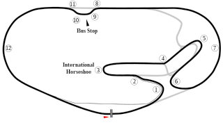
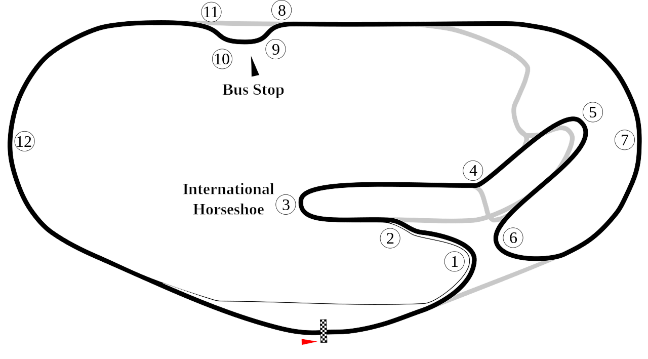
English: Track map of Daytona International Speedway showing mainly the road course. |
| 日期 | 7-8-2008 |
| 来源 | 自己的作品 |
| 作者 | Will Pittenger |
| 其他版本 |
|


| 相机位置 | | 在以下服务上查看本图像和附近其他图像: OpenStreetMap |
|---|
许可协议
| 我,本作品著作权人,释出本作品至公有领域。这适用于全世界。 在一些国家这可能不合法;如果是这样的话,那么: 我无条件地授予任何人以任何目的使用本作品的权利,除非这些条件是法律规定所必需的。 |
文件历史
点击某个日期/时间查看对应时刻的文件。
| 日期/时间 | 缩略图 | 大小 | 用户 | 备注 | |
|---|---|---|---|---|---|
| 当前 | 2012年1月28日 (六) 23:45 | | 1,281 × 710(41 KB) | Spyder Monkey | new bus stop route |
| 2009年10月25日 (日) 22:44 |  | 1,354 × 687(42 KB) | Spyder Monkey | ... | |
| 2009年10月25日 (日) 22:42 |  | 1,354 × 687(42 KB) | Spyder Monkey | added missing part of oval between 1-6, attempting to fix cropping issue... | |
| 2009年10月16日 (五) 02:37 |  | 1,354 × 687(42 KB) | Spyder Monkey | resize | |
| 2009年10月16日 (五) 02:35 |  | 1,281 × 710(41 KB) | Spyder Monkey | Corrected bus stop route & corner numbers | |
| 2008年7月8日 (二) 10:16 |  | 1,281 × 710(46 KB) | Will Pittenger | {{Information |Description={{en|1=Track map of w:Daytona International Speedway showing mainly the road course.}} |Source=Own work by uploader |Author=Will Pittenger |Date=7-8-2008 |Permission= |other_versions=[[Image:Daytona |
文件用途
以下页面使用本文件:
全域文件用途
以下其他wiki使用此文件:
- ca.wikipedia.org上的用途
- de.wikipedia.org上的用途
- 24-Stunden-Rennen von Daytona
- 24-Stunden-Rennen von Daytona 1981
- 24-Stunden-Rennen von Daytona 1967
- 24-Stunden-Rennen von Daytona 1966
- 24-Stunden-Rennen von Daytona 2018
- 24-Stunden-Rennen von Daytona 1983
- 24-Stunden-Rennen von Daytona 1982
- 24-Stunden-Rennen von Daytona 1980
- 24-Stunden-Rennen von Daytona 1979
- 24-Stunden-Rennen von Daytona 1978
- 24-Stunden-Rennen von Daytona 1977
- 24-Stunden-Rennen von Daytona 1976
- 24-Stunden-Rennen von Daytona 1975
- 24-Stunden-Rennen von Daytona 1973
- 6-Stunden-Rennen von Daytona 1980
- Kategorie:Daytona International Speedway
- en-two.iwiki.icu上的用途
- Daytona International Speedway
- 24 Hours of Daytona
- Oval track racing
- Daytona 200
- 2007 24 Hours of Daytona
- WeatherTech 240
- List of AMA Superbike Championship circuits
- List of Grand Prix motorcycle circuits
- 2009 24 Hours of Daytona
- List of IMSA GT Championship circuits
- 2009 Brumos Porsche 250
- 2010 24 Hours of Daytona
- List of World Sportscar Championship circuits
- 2011 24 Hours of Daytona
- 2012 24 Hours of Daytona
- 2013 24 Hours of Daytona
- 2008 24 Hours of Daytona
- 2014 24 Hours of Daytona
- 2015 24 Hours of Daytona
- 2016 24 Hours of Daytona
- 2017 24 Hours of Daytona
- 2006 24 Hours of Daytona
- 2005 24 Hours of Daytona
- 2004 24 Hours of Daytona
- 2003 24 Hours of Daytona
- 2002 24 Hours of Daytona
- 2001 24 Hours of Daytona
- 2018 24 Hours of Daytona
- 2000 24 Hours of Daytona
- 1999 24 Hours of Daytona
- 2019 24 Hours of Daytona
- List of IMSA SportsCar Championship circuits
- 2016 Finali Mondiali
查看本文件的更多全域用途。