
File:ESP-032436-1755-MarsCuriosityRover-MRO-HiRISE-20130627.jpg

本预览的尺寸:800 × 500像素。 其他分辨率:320 × 200像素 | 640 × 400像素 | 1,024 × 640像素 | 1,280 × 800像素 | 2,880 × 1,800像素。
原始文件 (2,880 × 1,800像素,文件大小:5.42 MB,MIME类型:image/jpeg)
摘要
| 描述 |
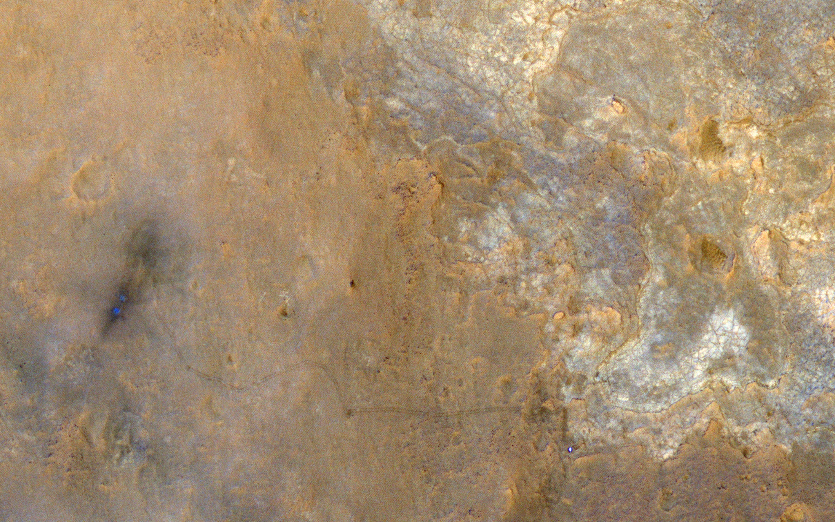
English: A Unique View of Curiosity Rover in Yellowknife Bay - This image was acquired with a large spacecraft roll to the east when the subsolar latitude was -7.26 degrees, close to the latitude of MSL (-4.6 degrees), resulting in an image with the sun, the MRO spacecraft, and the MSL Curiosity rover on the surface all aligned in nearly a straight line (phase angle of just 5.47 degrees).
This geometry hides shadows and better reveals subtle color variations. With enhanced colors, we can view the region around the landing site and Yellowknife Bay. The rover is the very bright spot near the lower right. The rover tracks stand out clearly in this view, extending west to the landing site where two bright, relatively blue spots indicate where MSL's landing jets cleared off the redder surface dust. The rover is now driving south towards the large mound in Gale Crater officially named Aeolis Mons and also called "Mount Sharp." |
| 日期 | |
| 来源 | http://www.uahirise.org/ESP_032436_1755 / http://www.uahirise.org/images/wallpaper/2880/ESP_032436_1755.jpg |
| 作者 | NASA/JPL-Caltech/Univ. of Arizona |
本图像或视频收录于美国国家航空航天局 (NASA)喷气推进实验室(Jet Propulsion Laboratory),其照片编号是: PIA17080 以及Alternate ID: ESP_032436_1755 此标签不表示文件的著作权状态。任何文件在附有此标签的同時还需要一个有效的著作权标签。请参阅许可协议说明页面以了解更多信息。 其他语言:
|
许可协议
| 本文件完全由NASA创作,在美国属于公有领域。根据NASA的版权方针,NASA的材料除非另有声明否则不受版权保护。(参见Template:PD-USGov/zh、NASA版权方针页面或JPL图片使用方针。) | ||
 |
警告:
|
文件历史
点击某个日期/时间查看对应时刻的文件。
| 日期/时间 | 缩略图 | 大小 | 用户 | 备注 | |
|---|---|---|---|---|---|
| 当前 | 2013年7月24日 (三) 19:56 | | 2,880 × 1,800(5.42 MB) | Drbogdan | User created page with UploadWizard |
文件用途
以下页面使用本文件:
全域文件用途
以下其他wiki使用此文件:
- en-two.iwiki.icu上的用途
- et.wikipedia.org上的用途
- uk.wikipedia.org上的用途