
File:Gulf of Saint Lawrence.jpg
此为最大尺寸。
Gulf_of_Saint_Lawrence.jpg (734 × 456像素,文件大小:99 KB,MIME类型:image/jpeg)
摘要
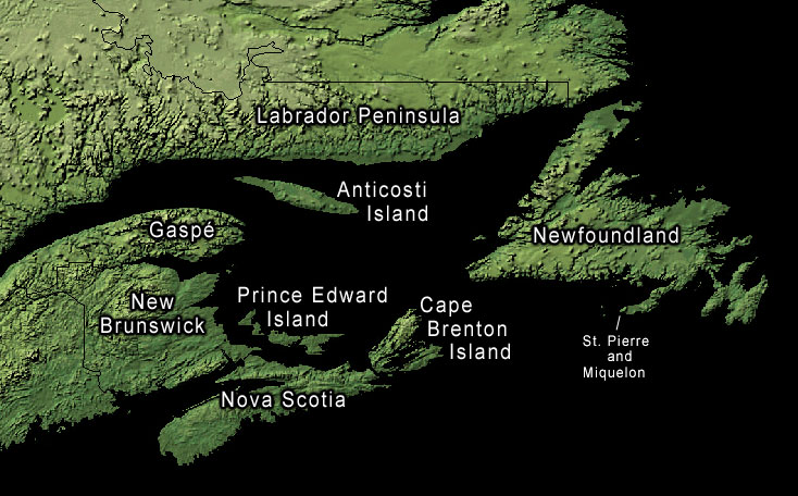
Land-cover imagery from USGS's National Map Server archive copy at the Wayback Machine. Photoshop file with layers is located here in case any modifications or translations are needed.
许可协议
此作品在美国属于公有领域,因为其是由美国政府的官员或雇员,基于其个人公务目的制作的作品,参考美国法典第17篇第1章第105条。
注意︰本模板仅适用于美国联邦政府的原创作品,不适用于任何美国州、属地、联邦个体、县、市或任何次级政府的作品。本模板也不适用于1978年以后由美国邮政署出版的邮票图案(参看美国版权局实践纲领第313.6(C)(1)条)。也不适用于部分美国硬币;参看美国铸币局使用条款。 |
 | |
| 本文件已被确认为免除已知的著作权法限制(包括所有相关权利)。 | ||
原始上传日志
原始描述頁面位於這裡。下列使用者名稱均來自en.wikipedia。
- 2006-01-30 20:43 Kelisi 734×456× (74652 bytes) same, with spelling correction
- 2005-10-23 17:10 Interiot 734×456× (101750 bytes) inc font size of "Gaspé"
- 2005-10-23 15:38 Interiot 734×456× (101801 bytes) more font tweaks
- 2005-10-23 15:32 Interiot 734×457× (101689 bytes) larger font
- 2005-10-23 15:26 Interiot 781×481× (111492 bytes) Map of the [[Gulf of Saint Lawrence]]. Land-cover imagery from [[USGS]]'s [http://nmviewogc.cr.usgs.gov/viewer.htm National Map Server].
文件历史
点击某个日期/时间查看对应时刻的文件。
| 日期/时间 | 缩略图 | 大小 | 用户 | 备注 | |
|---|---|---|---|---|---|
| 当前 | 2012年9月17日 (一) 22:23 | | 734 × 456(99 KB) | OgreBot | (BOT): Reverting to most recent version before archival |
| 2012年9月17日 (一) 22:23 |  | 734 × 456(73 KB) | OgreBot | (BOT): Uploading old version of file from en.wikipedia; originally uploaded on 2006-01-30 20:43:20 by Kelisi | |
| 2012年9月17日 (一) 22:23 |  | 734 × 456(99 KB) | OgreBot | (BOT): Uploading old version of file from en.wikipedia; originally uploaded on 2005-10-23 15:38:39 by Interiot | |
| 2012年9月17日 (一) 22:23 |  | 734 × 457(99 KB) | OgreBot | (BOT): Uploading old version of file from en.wikipedia; originally uploaded on 2005-10-23 15:32:33 by Interiot | |
| 2012年9月17日 (一) 22:23 |  | 781 × 481(109 KB) | OgreBot | (BOT): Uploading old version of file from en.wikipedia; originally uploaded on 2005-10-23 15:26:46 by Interiot | |
| 2006年1月29日 (日) 08:05 |  | 734 × 456(99 KB) | Kpjas | Land-cover imagery from USGS's [http://nmviewogc.cr.usgs.gov/viewer.htm National Map Server]. Photoshop file with layers is located [http://paperlined.org/apps/wikipedia/src_data/Gulf_of_Saint_Lawrence.psd here] in case any modifications or trans |
文件用途
以下页面使用本文件:
全域文件用途
以下其他wiki使用此文件:
- af.wikipedia.org上的用途
- az.wikipedia.org上的用途
- ba.wikipedia.org上的用途
- be.wikipedia.org上的用途
- bs.wikipedia.org上的用途
- ce.wikipedia.org上的用途
- cs.wikipedia.org上的用途
- el.wikipedia.org上的用途
- en-two.iwiki.icu上的用途
- fa.wikipedia.org上的用途
- fr.wikipedia.org上的用途
- he.wikipedia.org上的用途
- id.wikipedia.org上的用途
- it.wikipedia.org上的用途
- ko.wikipedia.org上的用途
- lv.wikipedia.org上的用途
- pl.wikipedia.org上的用途
- ro.wikipedia.org上的用途
- ru.wikipedia.org上的用途
- sh.wikipedia.org上的用途
- sk.wikipedia.org上的用途
- sr.wikipedia.org上的用途
- uk.wikipedia.org上的用途