
File:Hokushin-ron-Map.svg

此SVG文件的PNG预览的大小:800 × 512像素。 其他分辨率:320 × 205像素 | 640 × 409像素 | 1,024 × 655像素 | 1,280 × 819像素 | 2,560 × 1,638像素 | 1,038 × 664像素。
原始文件 (SVG文件,尺寸为1,038 × 664像素,文件大小:649 KB)
| 描述 |
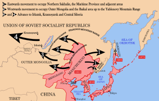
English: Strategic map of "Hoshukin-ron", the Japanese plans for a potential attack on the Soviet Union.
English: A map of the Imperial Powers of the Pacific, 1939-09-01. Dates shown indicate the approximate year that the various powers gain control of their possessions. Japanese control of territory in China was tenuous.
English: A Pacific-centered Mercator projection of the world with countries filled. Created in R using:
library(maps)
|
| 日期 | (UTC) |
| 来源 | |
| 作者 |
| 这是一张修改过的图片,这意味着它已在原版本的基础上通过软件进行了编辑,改动内容:Redrawn as vector image。其原始版本为:Pacific Area - The Imperial Powers 1939 - Map.jpg。修改者:Begoon。
|
本文件采用知识共享署名-相同方式共享 3.0 未本地化版本许可协议授权。
- 您可以自由地:
- 共享 – 复制、发行并传播本作品
- 修改 – 改编作品
- 惟须遵守下列条件:
- 署名 – 您必须对作品进行署名,提供授权条款的链接,并说明是否对原始内容进行了更改。您可以用任何合理的方式来署名,但不得以任何方式表明许可人认可您或您的使用。
- 相同方式共享 – 如果您再混合、转换或者基于本作品进行创作,您必须以与原先许可协议相同或相兼容的许可协议分发您贡献的作品。
原始上传日志
This image is a derivative work of the following images:
- File:Hokushin-ron-Map.png licensed with Cc-by-sa-3.0, GFDL
- 2010-08-26T14:40:14Z Begoon 1013x615 (185183 Bytes) remove headline/tweak type
- 2010-01-13T18:41:06Z 36ophiuchi 1013x615 (248571 Bytes) Fixed some minor errors.
- 2010-01-11T23:12:35Z 36ophiuchi 1013x615 (246326 Bytes) {{Information |Description={{en|1=Strategic map of "Hoshukin-ron", the Japanese plans for a potential attack on the Soviet Union.}} |Source=*[[:File:Pacific_Area_-_The_Imperial_Powers_1939_-_Map.svg|]] |Date=2010-01-11 23:11
- File:Pacific_Area_-_The_Imperial_Powers_1939_-_Map.svg licensed with Cc-by-sa-3.0, GFDL
- 2010-08-27T15:13:24Z Splittist 1039x814 (4653684 Bytes) There's no need to create a new file. The map description shows that this map deviates from the one from which it originated: many borders were modified: e.x. East Timor, Mengjiang. It also welcomes changes based on better in
- 2010-08-27T10:11:31Z Kintetsubuffalo 1039x814 (4658296 Bytes) then you are welcome to create your own file, rather than editwarring
- 2010-08-27T06:54:08Z Splittist 1039x814 (4653684 Bytes) Well that map (not the govt, a military academy; and by no means are maps on the area consistent in borders) is wrong. Sheng Shicai, who pledged allegiance to China, controlled Xinjiang in 1939. Marking Xinjiang as separate i
- 2010-08-27T03:36:43Z Kintetsubuffalo 1039x814 (4658296 Bytes) the US government map this is based on shows it as separate
- 2010-08-27T01:26:43Z Splittist 1039x814 (4653684 Bytes) No reason for Xinjiang to have separate borders from China
- 2009-05-31T02:33:19Z Kmusser 1039x814 (4658296 Bytes) add macau, fix marianas, hainan spelling
- 2008-10-30T15:20:49Z Valentim 1039x814 (4703043 Bytes) Reverted to version as of 05:16, 22 September 2008. The international name is "Sea of Japan".
- 2008-09-24T07:42:22Z 쿠도군 1039x814 (4704268 Bytes) Reverted to version as of 07:53, 11 September 2008
- 2008-09-22T05:16:58Z Chris 73 1039x814 (4703043 Bytes) Reverted to version as of 02:54, 21 August 2008
- 2008-09-11T07:53:32Z 쿠도군 1039x814 (4704268 Bytes) new version.
- 2008-08-21T02:54:43Z Emok 1039x814 (4703043 Bytes) {{Information |Description= |Source= |Date= |Author= |Permission= |other_versions= }}
- 2008-08-21T02:44:29Z Emok 1039x814 (4702923 Bytes) {{Information |Description= |Source= |Date= |Author= |Permission= |other_versions= }}
- 2008-08-08T01:16:33Z Emok 1039x814 (4678233 Bytes) {{Information |Description= |Source= |Date= |Author= |Permission= |other_versions= }}
- 2008-08-08T00:07:48Z Emok 1039x814 (4669659 Bytes) {{Information |Description= |Source= |Date= |Author= |Permission= |other_versions= }}
- 2008-08-07T05:03:23Z Emok 1039x814 (4669195 Bytes) {{Information |Description= |Source= |Date= |Author= |Permission= |other_versions= }}
- 2008-08-07T04:28:58Z Emok 1039x814 (4623405 Bytes) {{Information |Description= |Source= |Date= |Author= |Permission= |other_versions= }}
- 2008-08-07T04:02:57Z Emok 1039x814 (4602891 Bytes) {{Information |Description= |Source= |Date= |Author= |Permission= |other_versions= }}
- 2008-08-07T03:24:03Z Emok 1039x814 (4669511 Bytes) {{Information |Description= |Source= |Date= |Author= |Permission= |other_versions= }}
- 2008-08-04T16:59:39Z Emok 1039x814 (6442489 Bytes) {{Information |Description= |Source= |Date= |Author= |Permission= |other_versions= }}
- 2008-08-04T05:38:24Z Emok 1039x814 (6427678 Bytes) {{Information |Description= |Source= |Date= |Author= |Permission= |other_versions= }} [[Category:Imperialism]] [[Category:Oceania]]
- 2008-08-04T05:26:00Z Emok 104x82 (4765313 Bytes) {{Information |Description={{en|1=A map of the Imperial Powers of the Pacific, 1939-09-01. }} |Source=*[[:Image:World2Hires_filled_mercator.svg|]] |Date=2008-08-04 05:22 (UTC) |Author=*derivative work: ~~~ *[[:Image:World2Hir
- File:World2Hires_filled_mercator.svg licensed with Cc-by-sa-3.0, GFDL
- 2008-08-03T06:38:19Z Emok 220x171 (12002488 Bytes) {{Information |Description= |Source= |Date= |Author= |Permission= |other_versions= }} [[Category:Blank SVG maps of the world]]
- 2008-08-03T06:00:29Z Emok 520x519 (3064180 Bytes) {{Information |Description={{en|1=A Pacific-centered Mercator projection of the world with countries filled.}} |Source=Own work by uploader |Author=[[User:Emok|Emok]] |Date=2008-08-01 |Permission= |other_versions= }} {{Image
- File:Pacific_Area_-_The_Imperial_Powers_1939_-_Map.jpg licensed with PD-USGov-Military-Army
Uploaded with derivativeFX
文件历史
点击某个日期/时间查看对应时刻的文件。
| 日期/时间 | 缩略图 | 大小 | 用户 | 备注 | |
|---|---|---|---|---|---|
| 当前 | 2012年1月16日 (一) 03:37 | | 1,038 × 664(649 KB) | Quigley | Xinjiang wasn't separate from China |
| 2010年8月29日 (日) 05:40 |  | 1,038 × 664(653 KB) | Begoon | emphasise relevant font weights | |
| 2010年8月28日 (六) 10:04 |  | 1,038 × 664(628 KB) | Begoon | you'd think a mountain range would be big enough not to miss - fixed font for last one... | |
| 2010年8月28日 (六) 10:00 |  | 1,038 × 664(626 KB) | Begoon | font weight for Mountain ranges/Pt Arthur | |
| 2010年8月28日 (六) 09:43 |  | 1,038 × 664(619 KB) | Begoon | {{Information |Description={{en|1=Strategic map of "Hoshukin-ron", the Japanese plans for a potential attack on the Soviet Union.}} {{en|1=A map of the Imperial Powers of the Pacific, 1939-09-01. Dates shown indicate the approximate year that the various |
文件用途
以下页面使用本文件:
全域文件用途
以下其他wiki使用此文件:
- azb.wikipedia.org上的用途
- az.wikipedia.org上的用途
- bg.wikipedia.org上的用途
- en-two.iwiki.icu上的用途
- es.wikipedia.org上的用途
- fa.wikipedia.org上的用途
- fr.wikipedia.org上的用途
- he.wikipedia.org上的用途
- id.wikipedia.org上的用途
- it.wikipedia.org上的用途
- ja-two.iwiki.icu上的用途
- ko.wikipedia.org上的用途
- mn.wikipedia.org上的用途
- ms.wikipedia.org上的用途
- no.wikipedia.org上的用途
- pt.wikipedia.org上的用途
- ru.wikipedia.org上的用途
- uk.wikipedia.org上的用途
- www.wikidata.org上的用途