
File:Island of Ireland location map Clare.svg

此SVG文件的PNG预览的大小:481 × 599像素。 其他分辨率:192 × 240像素 | 385 × 480像素 | 616 × 768像素 | 822 × 1,024像素 | 1,643 × 2,048像素 | 1,450 × 1,807像素。
原始文件 (SVG文件,尺寸为1,450 × 1,807像素,文件大小:642 KB)
| 描述 |
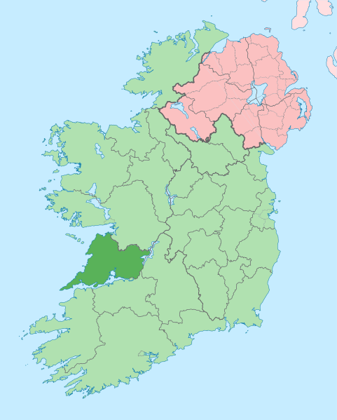
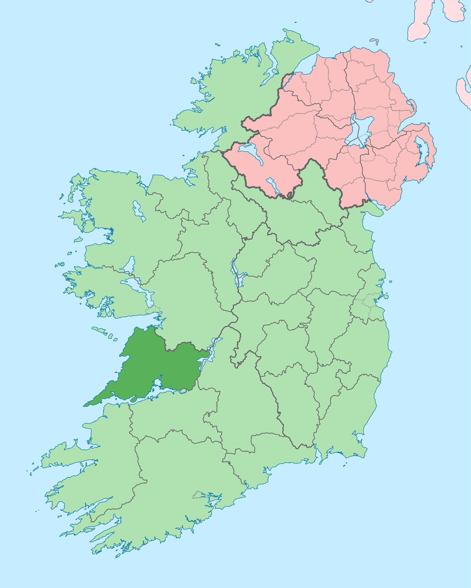
English: The island of Ireland, showing international border between Ireland and Northern Ireland, traditional provinces, traditional counties, and local authority areas in Ireland and Northern Ireland. |
| 日期 | (UTC) |
| 来源 | |
| 作者 |
|
| 这是一张修改过的图片,这意味着它已在原版本的基础上通过软件进行了编辑,改动内容:Coloured in regions with county of article highlighted。其原始版本为:Island of Ireland location map.svg。修改者:Mabuska。
|
我,本作品著作权人,特此采用以下许可协议发表本作品:
本文件采用知识共享署名-相同方式共享 3.0 未本地化版本许可协议授权。
- 您可以自由地:
- 共享 – 复制、发行并传播本作品
- 修改 – 改编作品
- 惟须遵守下列条件:
- 署名 – 您必须对作品进行署名,提供授权条款的链接,并说明是否对原始内容进行了更改。您可以用任何合理的方式来署名,但不得以任何方式表明许可人认可您或您的使用。
- 相同方式共享 – 如果您再混合、转换或者基于本作品进行创作,您必须以与原先许可协议相同或相兼容的许可协议分发您贡献的作品。
原始上传日志
This image is a derivative work of the following images:
- File:Island_of_Ireland_location_map.svg licensed with Cc-by-sa-3.0
- 2010-03-06T20:43:33Z Rannpháirtí anaithnid 1450x1807 (679207 Bytes) Fix incorrectly coloured isands.
- 2010-03-03T22:19:29Z Rannpháirtí anaithnid 1450x1807 (679744 Bytes) {{Information |Description={{de|Positionskarte von [[:de:Irland|Irland]]}} Quadratische Plattkarte, N-S-Streckung 170 %. Geographische Begrenzung der Karte: * N: 55.6° N * S: 51.2° N * W: 11.0° W * O: 5.0° W {{en|Location
Uploaded with derivativeFX
文件历史
点击某个日期/时间查看对应时刻的文件。
| 日期/时间 | 缩略图 | 大小 | 用户 | 备注 | |
|---|---|---|---|---|---|
| 当前 | 2020年6月28日 (日) 14:05 | | 1,450 × 1,807(642 KB) | Chipmunkdavis | Colouring in Aughinish |
| 2020年6月26日 (五) 15:54 |  | 1,450 × 1,807(642 KB) | Chipmunkdavis | Rmv stray number in code | |
| 2020年6月26日 (五) 15:26 |  | 1,450 × 1,807(642 KB) | Chipmunkdavis | Merging Tipperary and Waterford shapes | |
| 2020年6月26日 (五) 12:55 |  | 1,450 × 1,807(643 KB) | Chipmunkdavis | Removing Limerick City | |
| 2020年6月25日 (四) 16:21 |  | 1,450 × 1,807(643 KB) | Chipmunkdavis | Per the Local Government Reform Act 2014, removing the Tipperary border and the Waterford City border. | |
| 2020年6月25日 (四) 16:10 |  | 1,450 × 1,807(646 KB) | Chipmunkdavis | Removing lots of stray objects. Fixing location of Clare and one island slightly. | |
| 2020年6月25日 (四) 15:45 |  | 1,450 × 1,807(695 KB) | Chipmunkdavis | Colour islands in, place all islands and borders in groups, remove some blank and redundant shapes | |
| 2010年7月19日 (一) 00:41 |  | 1,450 × 1,807(815 KB) | Mabuska | {{Information |Description={{en|The island of Ireland, showing international border between Northern Ireland and Republic of Ireland, traditional provinces, traditional counties, and local authority areas in the Republic of Ireland and Northern Ireland.}} |
文件用途
以下页面使用本文件:
全域文件用途
以下其他wiki使用此文件:
- ar.wikipedia.org上的用途
- ast.wikipedia.org上的用途
- bg.wikipedia.org上的用途
- ca.wikipedia.org上的用途
- ceb.wikipedia.org上的用途
- cs.wikipedia.org上的用途
- en-two.iwiki.icu上的用途
- County Clare
- Inagh
- Ennis
- List of Ireland-related topics
- Shannon, County Clare
- Lissycasey
- Shannon Free Zone
- Lisdoonvarna
- Cratloe
- Doolin
- Kilfenora
- Ballyvaughan
- Carran
- Kilkee
- Kilrush
- Clarecastle
- Ennistymon
- Killaloe, County Clare
- Lahinch
- Liscannor
- Mountshannon
- Newmarket-on-Fergus
- O'Brien's Bridge
- Spanish Point, County Clare
- Aughinish, County Clare
查看本文件的更多全域用途。