
File:Junction of the Yukon and Koyukuk Rivers, Alaska.jpg

本预览的尺寸:704 × 600像素。 其他分辨率:282 × 240像素 | 564 × 480像素 | 902 × 768像素 | 1,202 × 1,024像素 | 2,405 × 2,048像素 | 3,177 × 2,706像素。
原始文件 (3,177 × 2,706像素,文件大小:5.96 MB,MIME类型:image/jpeg)
| 描述 |
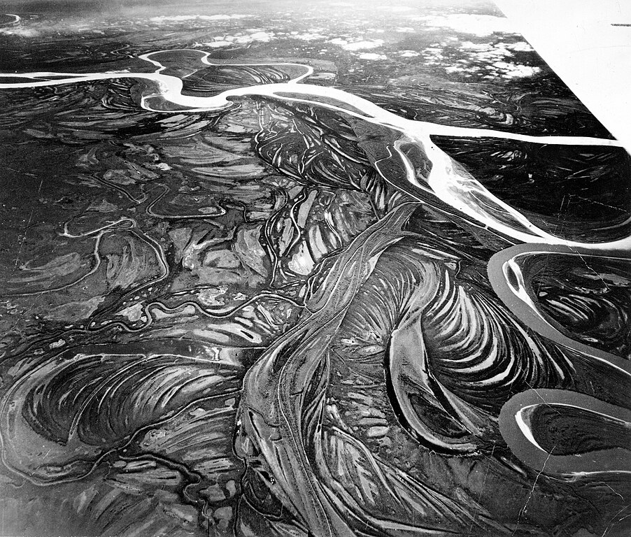
English: Alaska. High-altitude oblique aerial photograph looking south toward the junction of the Yukon and Koyukuk Rivers. The Koyukuk River (dark color) joins the silt-laden Yukon River (light color) at the right. (Aircraft wing visible at upper right corner of image.) |
|||
| 日期 | ||||
| 来源 | ptl00849.jpg in the USGS Denver Library Photographic Collection, USGS ScienceBase Catalog. This photograph appears as fig. 35 on p. 65 in: Troy Lewis Pewe (1975): Quaternary geology of Alaska. USGS Professional Paper 835 (download page) | |||
| 作者 | According to the caption in Pewe (1975) the photograph was taken by the U.S. Army Air Corps | |||
| 授权 (二次使用本文件) |
|
文件历史
点击某个日期/时间查看对应时刻的文件。
| 日期/时间 | 缩略图 | 大小 | 用户 | 备注 | |
|---|---|---|---|---|---|
| 当前 | 2017年9月18日 (一) 20:45 | | 3,177 × 2,706(5.96 MB) | Gretarsson | Upload of much larger version from USGS ScienceBase Catalog, reduced in size by 25% without information loss because the original file (9 MB) is somewhat blurry |
| 2008年2月16日 (六) 19:22 |  | 700 × 596(350 KB) | Andy king50 | {{Information |Description= Alaska. Braided drainage pattern near the junction of the Yukon River and Koyukuk River. The Koyukuk River (dark) joins the silt-laden Yukon River (lighter) at the right. (Aircraft wing visible at upper right corner of image.) |
文件用途
以下页面使用本文件:
全域文件用途
以下其他wiki使用此文件:
- ar.wikipedia.org上的用途
- cv.wikipedia.org上的用途
- de.wikipedia.org上的用途
- en-two.iwiki.icu上的用途
- fa.wikipedia.org上的用途
- fr.wikipedia.org上的用途
- id.wikipedia.org上的用途
- it.wikipedia.org上的用途
- it.wikibooks.org上的用途
- it.wikiversity.org上的用途
- la.wikipedia.org上的用途
- nl.wikipedia.org上的用途
- ru.wikipedia.org上的用途
- sk.wikipedia.org上的用途
- sl.wikipedia.org上的用途
- vi.wikipedia.org上的用途