
File:Loire-Atlantique urban areas.svg

此SVG文件的PNG预览的大小:400 × 320像素。 其他分辨率:300 × 240像素 | 600 × 480像素 | 960 × 768像素 | 1,280 × 1,024像素 | 2,560 × 2,048像素。
原始文件 (SVG文件,尺寸为400 × 320像素,文件大小:31 KB)
摘要
Origin: Based on fr:Image:Communauté urbaine de nantes.svg
Author: User:Poulpy, from an image by fr:Utilisateur:Zot
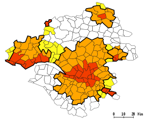
Description: Urban areas of the Loire-Atlantique french department.
- Red : urban communes which are also urban poles of a urban area
- Orange : other urban communes in a single urban area
- Yellow : urban communes linked to at least two urban areas
- White : Rural communes.
Urban areas borders shown in bold black:
- Nantes u.a.: center
- Saint-Nazaire u.a: left
- Châteaubriant u.a.: top
- Ancenis u.a.: right
- Clisson u.a.: bottom right
- Redon u.a.: top left
许可协议

|
本作品为自由软件,您可以依据自由软件基金会发行的GNU通用公共许可证第2版或任意后续版本的条款,传播和/或修改本作品。本作品发表时预期有用,但对此无任何保证,亦无隐含的可以销售或适合特定目的的保证。详情请见GNU通用公共许可证第2版和第3版。 |
文件历史
点击某个日期/时间查看对应时刻的文件。
| 日期/时间 | 缩略图 | 大小 | 用户 | 备注 | |
|---|---|---|---|---|---|
| 当前 | 2006年3月16日 (四) 11:21 | | 400 × 320(31 KB) | Poulpy | Added urban areas borders |
| 2006年3月16日 (四) 10:20 |  | 400 × 320(25 KB) | Poulpy | '''Origin''': Based on fr:Image:Communauté urbaine de nantes.svg '''Author''': User:Poulpy, from an image by fr:Utilisateur:Zot '''Description''': Urban areas of the Loire-Atlantique french department. * Red : urban ''communes'' which |
文件用途
没有页面链接到本图像。
全域文件用途
以下其他wiki使用此文件:
- br.wikipedia.org上的用途
- es.wikipedia.org上的用途
- fr.wikipedia.org上的用途
- nl.wikipedia.org上的用途