
File:Matewan West Virginia floodwall.jpg

本预览的尺寸:800 × 534像素。 其他分辨率:320 × 214像素 | 640 × 428像素 | 1,024 × 684像素 | 1,500 × 1,002像素。
原始文件 (1,500 × 1,002像素,文件大小:1.1 MB,MIME类型:image/jpeg)
| 描述 |
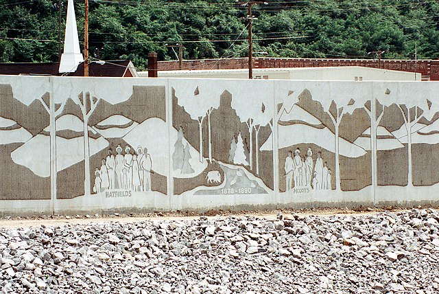
English: Close-up of a section of the floodwall along the Tug Fork River at Matewan, West Virginia, USA. The U.S. Army Corps of Engineers constructed levees and floodwalls along the river to protect the town. The wall depicts the families involved in the notorious Hatfield-McCoy feud of 1878–1891. |
|||
| 日期 | ||||
| 来源 |
U.S. Army Corps of Engineers Digital Visual Library Image page Image description page Digital Visual Library home page |
|||
| 作者 | U.S. Army Corps of Engineers, photographer not specified or unknown | |||
| 授权 (二次使用本文件) |
|
|||
| 图中地点 | Matewan, West Virginia, USA |
| 相机位置 | | 在以下服务上查看本图像和附近其他图像: OpenStreetMap |
|---|
文件历史
点击某个日期/时间查看对应时刻的文件。
| 日期/时间 | 缩略图 | 大小 | 用户 | 备注 | |
|---|---|---|---|---|---|
| 当前 | 2007年3月31日 (六) 19:23 | | 1,500 × 1,002(1.1 MB) | DanMS | {{Information | Description = {{en|Close-up of a section of the floodwall along the Tug Fork River at Matewan, West Virginia, USA. The U.S. Army Corps of Engineers constructed levees and floodwalls along the river to protect the town. The wall depicts |
文件用途
以下页面使用本文件:
全域文件用途
以下其他wiki使用此文件:
- en-two.iwiki.icu上的用途
- es.wikipedia.org上的用途
- hu.wikipedia.org上的用途