
File:PIA16227-MarsCuriosityRover-Rocknest-20121012.jpg

原始文件 (7,703 × 2,198像素,文件大小:1.82 MB,MIME类型:image/jpeg)
摘要
| 描述 |
English: 10.12.2012
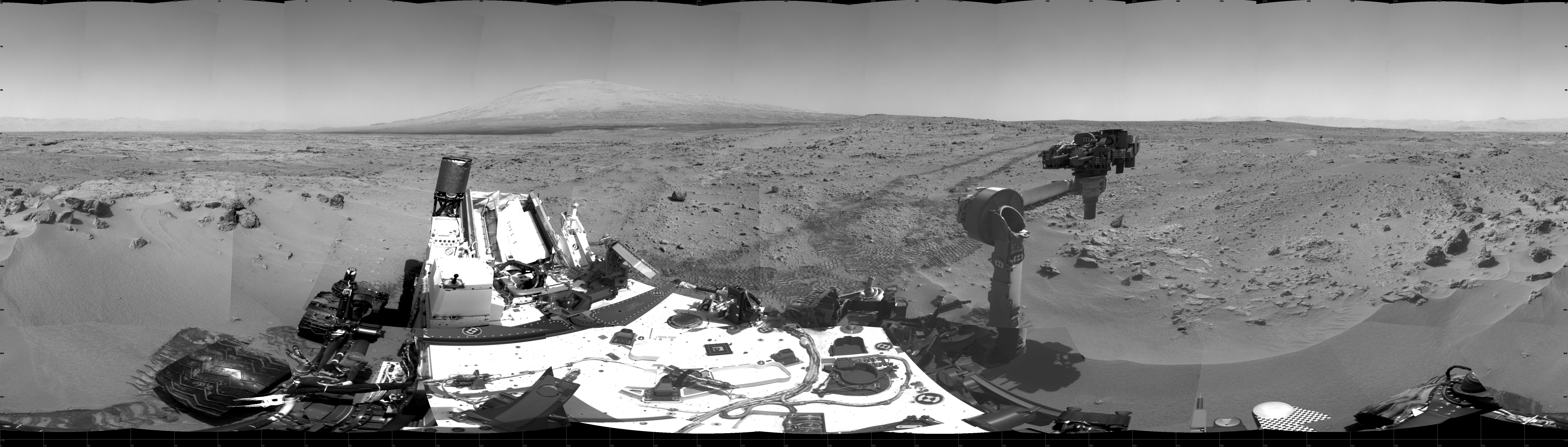
Curiosity's Location During First Scooping This 360-degree scene shows the surroundings of the location where NASA Mars rover Curiosity arrived on the 59th Martian day, or sol, of the rover's mission on Mars (Oct. 5, 2012). It is a mosaic of images taken by Curiosity's Navigation Camera (Navcam) on sols 59 and 60. Smooth surfaces of the windblown sand and dust of the "Rocknest" area, in the foreground, are what signaled from a distance that this might be an appropriate place to spend about three weeks collecting and using the mission's first few scoopfuls of soil. The rover scooped up its first sample on Sol 61 (Oct. 7, 2012). South is at the center of this panorama, north at both ends. Mount Sharp is on the horizon in the southeast. The "Glenelg" area planned as the next destination lies to the east. Tracks that Curiosity's wheels made while driving toward Rocknest recede toward the west. For scale, Curiosity leaves parallel tracks about 9 feet (2.7 meters) apart. The scene is presented here as a cylindrical projection. Image Credit: NASA/JPL-Caltech |
| 日期 | |
| 来源 | http://photojournal.jpl.nasa.gov/jpeg/PIA16227.jpg |
| 作者 | NASA/JPL-Caltech |
| 其他版本 | http://photojournal.jpl.nasa.gov/catalog/PIA16227 |
许可协议
| 本文件完全由NASA创作,在美国属于公有领域。根据NASA的版权方针,NASA的材料除非另有声明否则不受版权保护。(参见Template:PD-USGov/zh、NASA版权方针页面或JPL图片使用方针。) | ||
 |
警告:
|
文件历史
点击某个日期/时间查看对应时刻的文件。
| 日期/时间 | 缩略图 | 大小 | 用户 | 备注 | |
|---|---|---|---|---|---|
| 当前 | 2012年10月13日 (六) 14:40 | 7,703 × 2,198(1.82 MB) | Drbogdan | User created page with UploadWizard |
文件用途
以下页面使用本文件:
全域文件用途
以下其他wiki使用此文件:
- fr.wikipedia.org上的用途
- uk.wikipedia.org上的用途