
File:PIA17939-MarsCuriosityRover-AfterCrossingDingoGapSanddune-20140210.jpg

原始文件 (1,024 × 1,024像素,文件大小:162 KB,MIME类型:image/jpeg)
摘要
| 描述 |
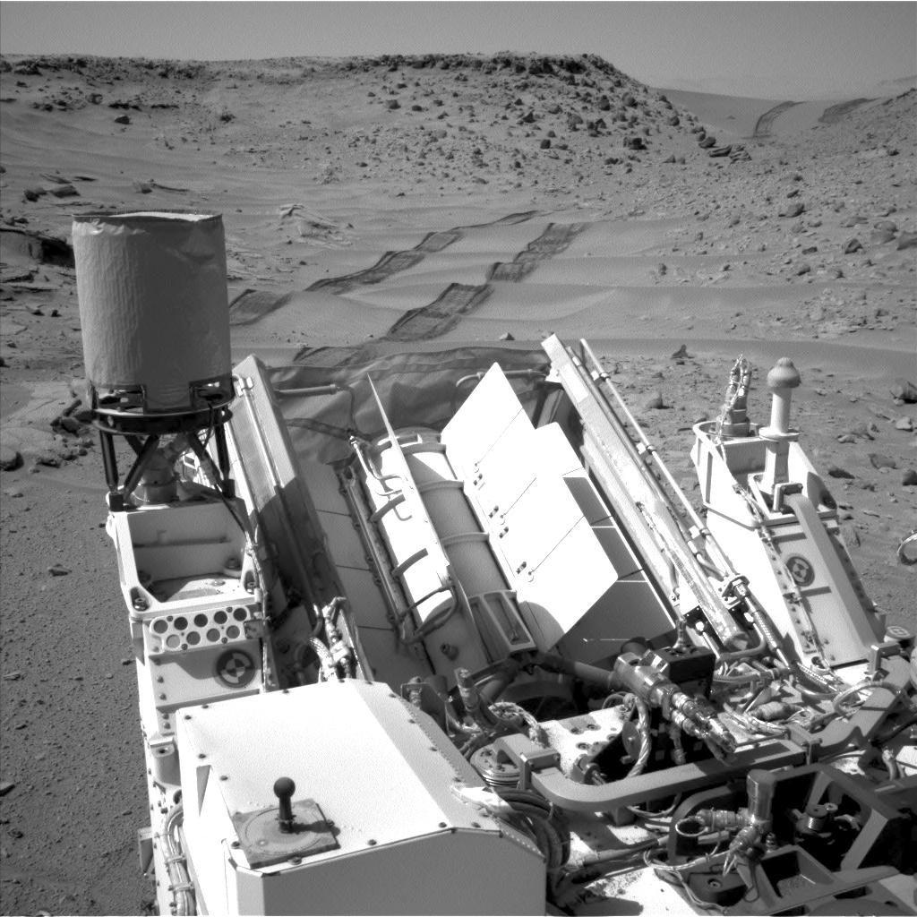
English: PIA17939: Curiosity Making Headway West of 'Dingo Gap'
http://photojournal.jpl.nasa.gov/catalog/PIA17939 NASA's Curiosity Mars rover used the Navigation Camera (Navcam) on its mast to catch this look-back eastward at wheel tracks from driving through and past "Dingo Gap" inside Gale Crater. The gap, spanned by a 3-foot-tall (1-meter-tall) dune, is at the right-hand side of the horizon in this scene. Curiosity crossed the dune on the 535th Martian day, or sol, of the rover's work on Mars (Feb. 6). On Sol 538 (Feb. 9), it drove 135 feet (41.1 meters) farther westward. This image was taken on Sol 539 (Feb. 10) from the location reached by the previous sol's drive. For scale, the distance between the parallel wheel tracks is about 9 feet (2.7 meters). The high-mounted cylinder on the rear part of the vehicle is the rover's UHF (ultrahigh frequency) antenna. The set of disks mounted below it is part of the calibration target for Curiosity's Chemistry and Camera (ChemCam) instrument. The ball-on-a-stick device in the foreground is the calibration target, including a sundial, for Curiosity's Mast Camera (Mastcam). To the right of the UHF antenna in this image are the radiator fins for Curiosity's power supply, a radioisotope thermoelectric generator. NASA's Jet Propulsion Laboratory, Pasadena, Calif., manages the Mars Science Laboratory Project and the mission's Curiosity rover for NASA's Science Mission Directorate in Washington. The rover was designed and assembled at JPL, a division of the California Institute of Technology in Pasadena. More information about Curiosity is online at http://www.nasa.gov/msl and http://mars.jpl.nasa.gov/msl/.Polski: Należący do NASA łazik Curiosity użył umieszczonej na maszcie kamery nawigacyjnej (Navcam), do wykonania zdjęcia będącego spojrzeniem w tył, na wschód, na ślady swoich kół, pozostawione w kraterze Gale, po przejściu "Dingo Gap". Luka, będąca wydmą sięgającą wysokości 1 metra, znajduje się na horyzoncie z prawej strony zdjęcia. Curiosity przejechał wydmę w 535 marsjańskin dniu, lub sol, podczas realizacji swojej misji na Marsie. Na Ziemi wtedy był 6 luty 2014. W Sol 538 (9 luty 2014), łazik przejechał 41.1 metrów dalej na zachód. Zdjęcie to, zostało wykonane w Sol 539 (10 luty 2014) z miejsca które łazik osiągnął w poprzednim marsjańskm dniu. Dla porównania, rozpiętość dwóch równoległych śladów kół łazika wynosi około 2.7 metra.
Wysoko zamontowany cylinder w tylnej części pojazdu jest anteną UHF. Zestaw dziewięciu okrągłych elementów zamontowanych poniżej to część obiektów kalibracyjnych instrumentu ChemCam. Znajdujący się na pierwszym planie drążek wystający z centrum koła, to zegar słoneczny będący częścią obiektu kalibracyjnego dla kamer masztowych łazika Curiosity. Na pawo od anteny UHF widać płetwy radiatora urządzenia będącego źródłem prądu elektrycznego łazika, radioizotopowego generatora termoelektrycznego ang. radioiosotope thermoelectric generator. Należące do NASA Jet Propulsion Laboratory, będące oddziałem California Institute of Technology w Pasadenie, kieruje projektem Mars Science Laboratory dla należącego do NASA Science Mission Directorate w Waszygtonie. JPL zaprojektowało i zbudowało łazik Curiosity. Malin Space Science Systems z San Diego, zbudowało i steruje kamerami masztowymi łazika (ang. Mastcams). |
| 日期 | |
| 来源 | http://photojournal.jpl.nasa.gov/jpeg/PIA17939.jpg |
| 作者 | NASA/JPL-Caltech |
许可协议
| 本文件完全由NASA创作,在美国属于公有领域。根据NASA的版权方针,NASA的材料除非另有声明否则不受版权保护。(参见Template:PD-USGov/zh、NASA版权方针页面或JPL图片使用方针。) | ||
 |
警告:
|
文件历史
点击某个日期/时间查看对应时刻的文件。
| 日期/时间 | 缩略图 | 大小 | 用户 | 备注 | |
|---|---|---|---|---|---|
| 当前 | 2014年2月12日 (三) 02:17 | | 1,024 × 1,024(162 KB) | Drbogdan | User created page with UploadWizard |
文件用途
以下页面使用本文件:
全域文件用途
以下其他wiki使用此文件:
- en-two.iwiki.icu上的用途
- fr.wikipedia.org上的用途
- it.wikipedia.org上的用途
- pl.wikipedia.org上的用途
- uk.wikipedia.org上的用途