
File:PIA18781-MarsCuriosityRover-GeologyMap-LowerMountSharp-20140911.jpg

原始文件 (4,173 × 3,008像素,文件大小:4.41 MB,MIME类型:image/jpeg)
摘要
| 描述 |
English: 09.11.2014
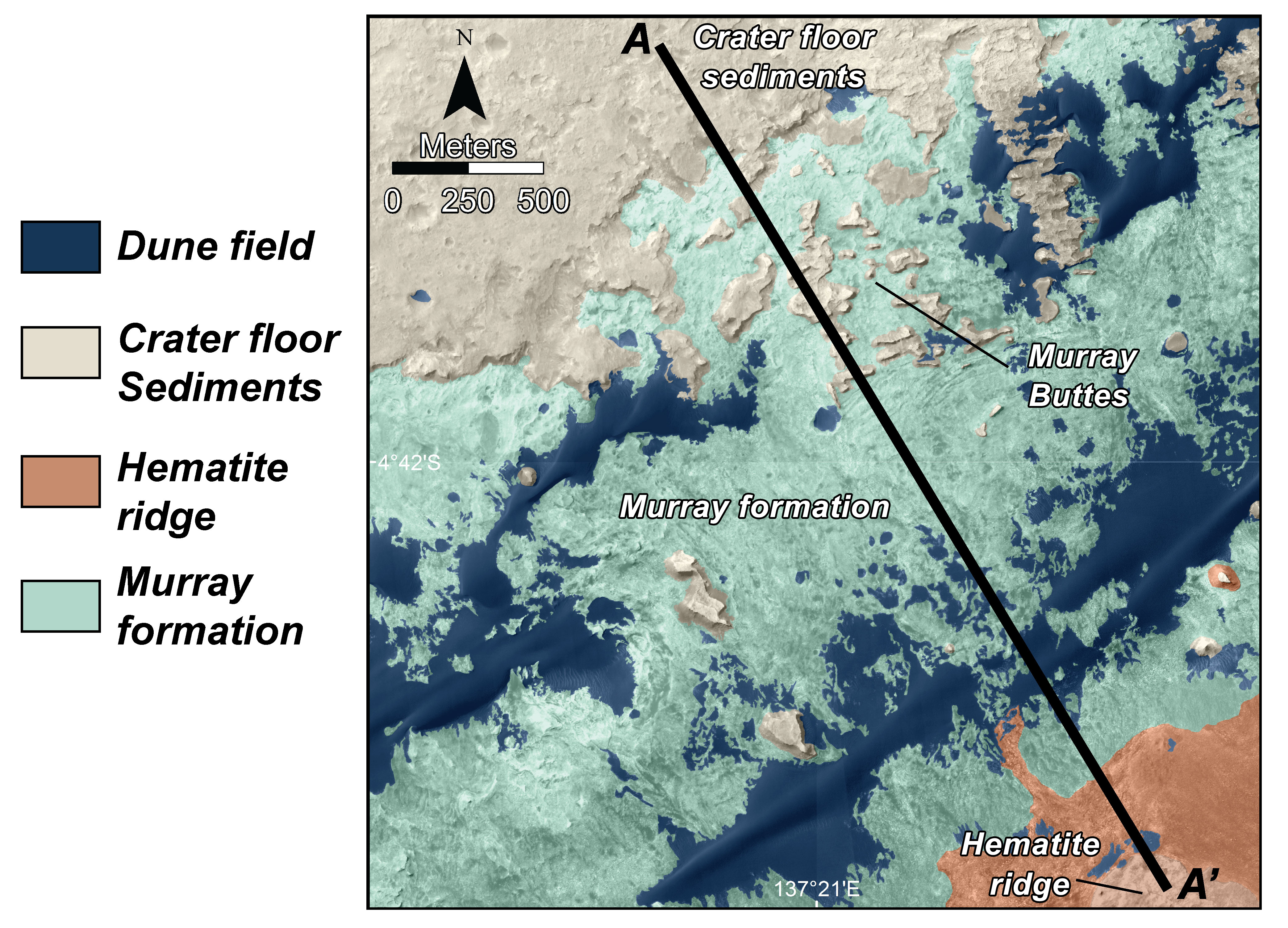
Map of Lower Mount Sharp - in Gale Crater on the planet Mars http://mars.jpl.nasa.gov/msl/multimedia/images/?ImageID=6580 This is a map of lower Mount Sharp on Mars, showing the major geologic units identified from orbit. The rocks of the "Murray Formation," mapped in green, likely represent the oldest layers of Mount Sharp that NASA's Curiosity rover will explore. The Murray formation is in contact with two other major units: The sedimentary rocks of the crater floor that Curiosity has been exploring for the past two years, and the hematite ridge, a feature on Mount Sharp that shows a very distinct mineral composition from orbit. The segment A to A' corresponds to the geologic cross-section presented in PIA18782. This image was made using the data from the High Resolution Imaging Science Experiment (HiRISE) camera, one of six instruments on NASA's Mars Reconnaissance Orbiter. The University of Arizona, Tucson, operates HiRISE, which was built by Ball Aerospace & Technologies Corp., Boulder, Colorado. NASA's Jet Propulsion Laboratory, a division of the California Institute of Technology in Pasadena, manages the Mars Reconnaissance Orbiter and Mars Science Laboratory projects for NASA's Science Mission Directorate, Washington. |
| 日期 | |
| 来源 | http://mars.jpl.nasa.gov/msl/images/NASA-MSL-Curiosity-Rover-Map-of-Lower-Mount-Sharp-Geology-pia18781-full.jpg |
| 作者 | NASA/JPL-Caltech/Univ. of Arizona |
许可协议
| 本文件完全由NASA创作,在美国属于公有领域。根据NASA的版权方针,NASA的材料除非另有声明否则不受版权保护。(参见Template:PD-USGov/zh、NASA版权方针页面或JPL图片使用方针。) | ||
 |
警告:
|
文件历史
点击某个日期/时间查看对应时刻的文件。
| 日期/时间 | 缩略图 | 大小 | 用户 | 备注 | |
|---|---|---|---|---|---|
| 当前 | 2014年9月19日 (五) 15:55 | | 4,173 × 3,008(4.41 MB) | Drbogdan | User created page with UploadWizard |
文件用途
以下页面使用本文件:
全域文件用途
以下其他wiki使用此文件:
- en-two.iwiki.icu上的用途
- tr.wikipedia.org上的用途
- uk.wikipedia.org上的用途