
File:PIA21145-MarsCuriosityRoverMission-20161213.png

原始文件 (1,490 × 804像素,文件大小:578 KB,MIME类型:image/png)
摘要
| 描述 |
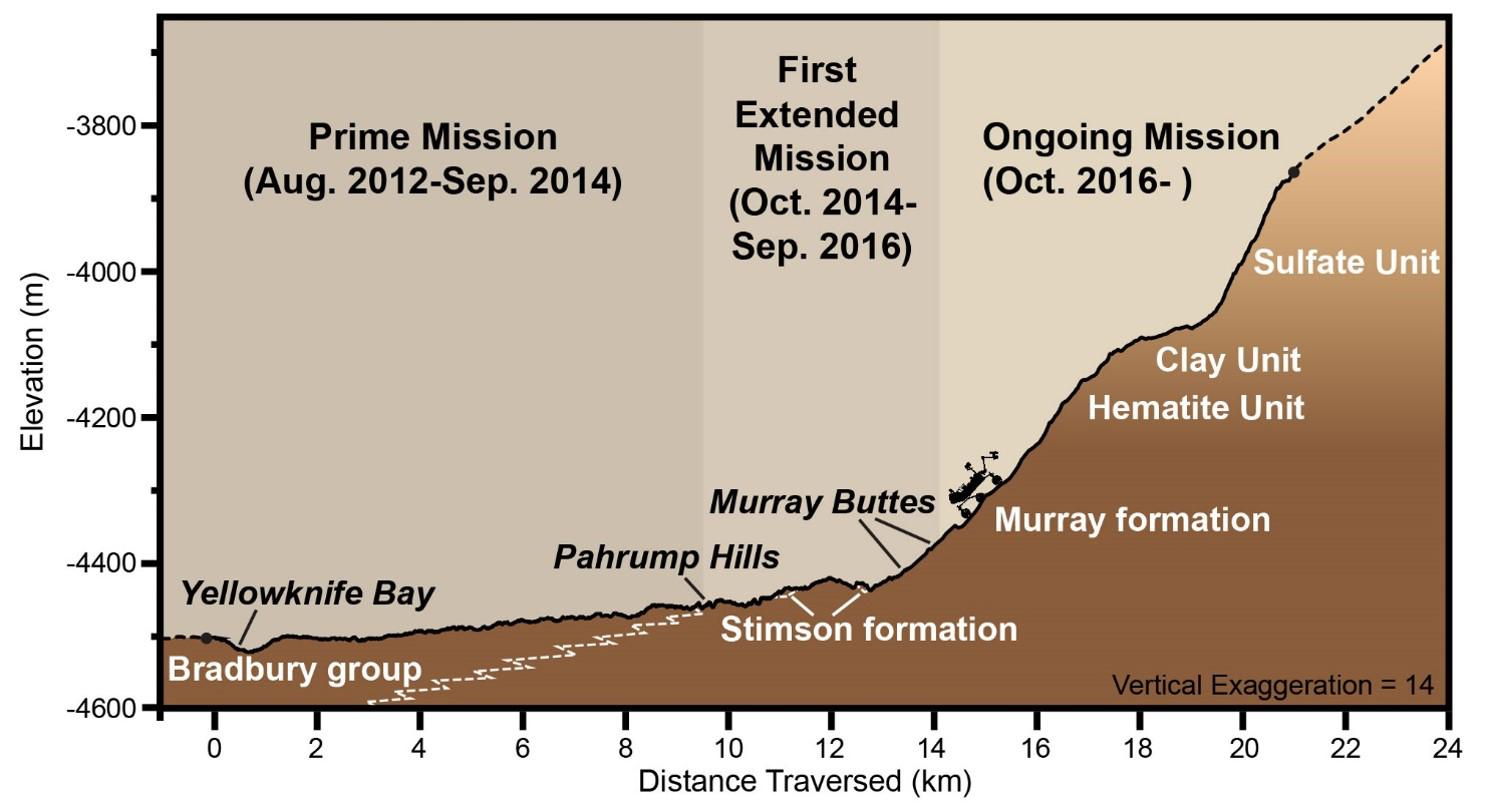
English: PIA21145: Curiosity Rover's Martian Mission, Exaggerated Cross Section
http://photojournal.jpl.nasa.gov/catalog/PIA21145 This graphic depicts aspects of the driving distance, elevation, geological units and time intervals of NASA's Curiosity Mars rover mission, as of late 2016. The vertical dimension is exaggerated 14-fold compared with the horizontal dimension, for presentation-screen proportions. As of early December 2016, Curiosity had driven 9.3 miles (15 kilometers) since its August 2012 landing on the floor of Gale Crater near the base of Mount Sharp. It had climbed 541 feet (165 meters) in elevation. Elevation values shown on the vertical scale of this chart denote meters below an established zero-elevation level on Mars, which lacks a planetary "sea level." Because Curiosity is below the zero elevation, the numbers are negative. Presented at the 2016 AGU Fall Meeting on Dec. 13. in San Francisco, CA. NASA's Jet Propulsion Laboratory, a division of Caltech in Pasadena, California, manages the Mars Science Laboratory Project for NASA's Science Mission Directorate, Washington. For more information about Curiosity, visit http://www.nasa.gov/msl and http://mars.jpl.nasa.gov/msl. |
| 日期 | |
| 来源 | http://photojournal.jpl.nasa.gov/jpeg/PIA21145.jpg |
| 作者 | NASA/JPL-Caltech |
许可协议
| 本文件完全由NASA创作,在美国属于公有领域。根据NASA的版权方针,NASA的材料除非另有声明否则不受版权保护。(参见Template:PD-USGov/zh、NASA版权方针页面或JPL图片使用方针。) | ||
 |
警告:
|
文件历史
点击某个日期/时间查看对应时刻的文件。
| 日期/时间 | 缩略图 | 大小 | 用户 | 备注 | |
|---|---|---|---|---|---|
| 当前 | 2016年12月16日 (五) 02:00 | | 1,490 × 804(578 KB) | Drbogdan | User created page with UploadWizard |
文件用途
以下页面使用本文件:
全域文件用途
以下其他wiki使用此文件:
- en-two.iwiki.icu上的用途
- fr.wikipedia.org上的用途
- it.wikipedia.org上的用途