
File:Partition of India.PNG

此为最大尺寸。
Partition_of_India.PNG (450 × 400像素,文件大小:27 KB,MIME类型:image/png)

|
此historical map图片可使用矢量图形重新创建为SVG文件。这具有很多好处;更多信息请参见共享资源:待清理媒体。如果存在此图片的SVG格式,请将其上传,然后将此模板替换为
{{vector version available|新图片名称}}。
建议您将SVG命名为“Partition of India.svg”,这样在使用Vector version available(或Vva)模板时就不需要填写新图片名称参数。 |

|
This map has been uploaded by Electionworld from en-two.iwiki.icu to enable the |
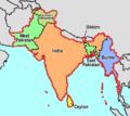
Map showing the Partition of India, by McMullen
| 我,本作品著作权人,释出本作品至公有领域。这适用于全世界。 在一些国家这可能不合法;如果是这样的话,那么: 我无条件地授予任何人以任何目的使用本作品的权利,除非这些条件是法律规定所必需的。 |
[]
-
 English
 -
 English
 -
 Esperanto
 -
 español
 -
 français
 -
 italiano
 -
 magyar
 -
 Bahasa Melayu
 -
 polski
 -
 нохчийн
 -
 русский
 -
 मराठी
मराठी -
 हिन्दी
 -
 বাংলা
বাংলা -
 বাংলা
বাংলা -
 ਪੰਜਾਬੀ
 -
 ગુજરાતી
 -
 ಕನ್ನಡ
ಕನ್ನಡ -
 עברית
עברית -
 سنڌي
سنڌي -
 اردو
اردو -
 العربية
 -
 فارسی
فارسی


.svg)


文件历史
点击某个日期/时间查看对应时刻的文件。
| 日期/时间 | 缩略图 | 大小 | 用户 | 备注 | |
|---|---|---|---|---|---|
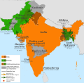
| 当前 | 2018年11月20日 (二) 06:58 | | 450 × 400(27 KB) | ARR8 | |
| 2006年12月13日 (三) 22:51 |  | 450 × 400(19 KB) | Electionworld | {{ew|en|McMullen}} Map showing the Partition of India, by McMullen {{PD-self}} |
文件用途
以下页面使用本文件:
全域文件用途
以下其他wiki使用此文件:
- anp.wikipedia.org上的用途
- ar.wikipedia.org上的用途
- ast.wikipedia.org上的用途
- ca.wikipedia.org上的用途
- ckb.wikipedia.org上的用途
- el.wikipedia.org上的用途
- en-two.iwiki.icu上的用途
- en.wikivoyage.org上的用途
- es.wikipedia.org上的用途
- et.wikipedia.org上的用途
- gu.wikipedia.org上的用途
- hr.wikipedia.org上的用途
- id.wikipedia.org上的用途
- io.wikipedia.org上的用途
- ja-two.iwiki.icu上的用途
- ka.wikipedia.org上的用途
- nl.wikipedia.org上的用途
- ru.wikipedia.org上的用途
- sh.wikipedia.org上的用途
- sq.wikipedia.org上的用途
- sr.wikipedia.org上的用途
- ta.wikiquote.org上的用途
- te.wikipedia.org上的用途
- uk.wikipedia.org上的用途
- www.wikidata.org上的用途
- zh-yue.wikipedia.org上的用途