
File:US Secession map 1861.svg

此SVG文件的PNG预览的大小:787 × 483像素。 其他分辨率:320 × 196像素 | 640 × 393像素 | 1,024 × 628像素 | 1,280 × 786像素 | 2,560 × 1,571像素。
原始文件 (SVG文件,尺寸为787 × 483像素,文件大小:111 KB)
摘要
{{Information
|Description=
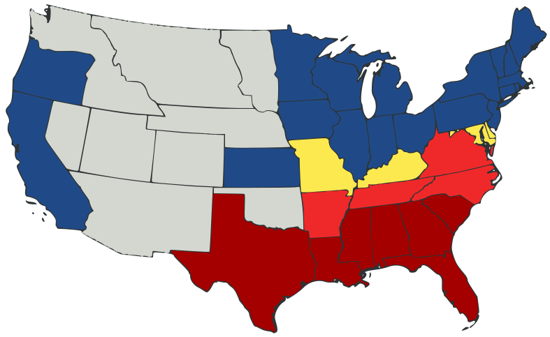
English: United States map of 1861, showing affiliation of states and territories regarding secession from the Union at the start of the American Civil War.
Legend:
States that seceded before April 15, 1861
States that seceded after April 15, 1861
States that permitted slavery, but did not secede
States of the Union where slavery was banned
U.S. territories, under Union Army control
|Date=2007-02-23
|Source=
A trace, retouch, and recolour of Image:Secession Map of the United States, 1861.png by User:Tomf688.
|Author=[[User:ions= |Other fields= }}
许可协议
本文件采用知识共享署名-相同方式共享 3.0 未本地化版本许可协议授权。
- 您可以自由地:
- 共享 – 复制、发行并传播本作品
- 修改 – 改编作品
- 惟须遵守下列条件:
- 署名 – 您必须对作品进行署名,提供授权条款的链接,并说明是否对原始内容进行了更改。您可以用任何合理的方式来署名,但不得以任何方式表明许可人认可您或您的使用。
- 相同方式共享 – 如果您再混合、转换或者基于本作品进行创作,您必须以与原先许可协议相同或相兼容的许可协议分发您贡献的作品。
文件历史
点击某个日期/时间查看对应时刻的文件。
| 日期/时间 | 缩略图 | 大小 | 用户 | 备注 | |
|---|---|---|---|---|---|
| 当前 | 2007年2月23日 (五) 23:47 | | 787 × 483(111 KB) | Tintazul | {{Tintazul |Description=United States map of 1861, show affiliation of states and territories regarding the Secession War (Civil War.) Legend: {{legend|#A40000|States that seceded before April 15, 1861}} {{legend|#EF2929|States that seceded after April 15 |
文件用途
以下页面使用本文件:
全域文件用途
以下其他wiki使用此文件:
- ar.wikipedia.org上的用途
- arz.wikipedia.org上的用途
- be.wikipedia.org上的用途
- bg.wikipedia.org上的用途
- bs.wikipedia.org上的用途
- cy.wikipedia.org上的用途
- da.wikipedia.org上的用途
- el.wikipedia.org上的用途
- en-two.iwiki.icu上的用途
- American Civil War
- Irredentism
- Origins of the American Civil War
- User:Jimmuldrow/Sandbox
- Upland South
- User:ArmyAnt/Sandbox
- Presidency of Abraham Lincoln
- Presidency of James Buchanan
- James Buchanan
- Central Confederacy
- User:Themaster1112/sandbox
- User:2know4power/sandbox
- User:LukeRun82
- User:Orser67/Lincoln
- User:Falcaorib/Canada, United States and Mexico
- es.wikipedia.org上的用途
- eu.wikipedia.org上的用途
- gd.wikipedia.org上的用途
- he.wikipedia.org上的用途
- hr.wikipedia.org上的用途
- hy.wikipedia.org上的用途
- it.wikipedia.org上的用途
- ka.wikipedia.org上的用途
- lij.wikipedia.org上的用途
- lt.wikipedia.org上的用途
- ml.wikipedia.org上的用途
- ne.wikipedia.org上的用途
- no.wikipedia.org上的用途
- pl.wikipedia.org上的用途
查看此文件的更多全域用途。