
File:US humid subtropical.png

本预览的尺寸:800 × 552像素。 其他分辨率:320 × 221像素 | 640 × 441像素 | 841 × 580像素。
原始文件 (841 × 580像素,文件大小:15 KB,MIME类型:image/png)
摘要
| 描述 |
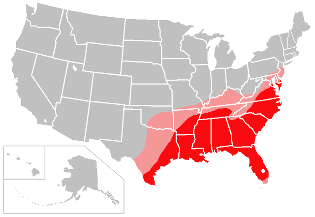
English: The red shading on this map denotes areas of the United States with a solidly humid subtropical climate; the pink shading denotes areas of the United States with a transitional/borderline humid subtropical climate.
I created this map based largely on the information contained in the Humid subtropical climate article, with supplemental information gleaned from articles about various US cities and states. Consider this to be a work in progress and feel free to suggest changes/corrections to me or make them yourself, if necessary. Points of clarification:
|
| 日期 | 2007年1月6日 (原始上传日期) |
| 来源 | Created by user:Caliga10 |
| 作者 | 英语维基百科的Caliga10 |
许可协议
| 本文件采用知识共享署名-相同方式共享 3.0 未本地化版本许可协议授权。 受免責聲明的約束。 | ||
| 署名: Caliga10 位于英语维基百科 | ||
| ||
| 本许可协议标签作为GFDL许可协议更新的组成部分被添加至本文件。 |

|
已授权您依据自由软件基金会发行的无固定段落及封面封底文字(Invariant Sections, Front-Cover Texts, and Back-Cover Texts)的GNU自由文件许可协议1.2版或任意后续版本的条款,复制、传播和/或修改本文件。该协议的副本请见“GNU Free Documentation License”。 受免責聲明的約束。 |
原始上传日志
原始描述頁面位於這裡。下列使用者名稱均來自en.wikipedia。
- 2007-02-13 04:18 Caliga10 841×580× (15462 bytes) Updated version of this map, based on input from [[user:CrazyC83|CrazyC83]]. The following changes have been made: South Florida (except the Florida Keys) is shaded as a transitional zone (to a full tropical climate; the Keys remain unshaded since they
- 2007-01-06 23:25 Caliga10 841×580× (15505 bytes) Created by [[user:Caliga10]] I created this map based largely on the information contained in the [[Humid subtropical climate]] article, with supplemental information gleaned from articles about various US cities and states. Consider this to be a work in
文件历史
点击某个日期/时间查看对应时刻的文件。
| 日期/时间 | 缩略图 | 大小 | 用户 | 备注 | |
|---|---|---|---|---|---|
| 当前 | 2013年7月27日 (六) 05:56 | | 841 × 580(15 KB) | OgreBot | (BOT): Uploading old version of file from en.wikipedia; originally uploaded on 2007-02-13 04:18:41 by Caliga10 |
| 2013年7月27日 (六) 05:56 |  | 841 × 580(15 KB) | OgreBot | (BOT): Uploading old version of file from en.wikipedia; originally uploaded on 2007-01-06 23:25:26 by Caliga10 | |
| 2013年7月25日 (四) 09:44 |  | 800 × 552(104 KB) | Encore007 | User created page with UploadWizard |
文件用途
以下页面使用本文件:
全域文件用途
以下其他wiki使用此文件:
- ar.wikipedia.org上的用途
- en-two.iwiki.icu上的用途
- it.wikipedia.org上的用途
- ja-two.iwiki.icu上的用途
- no.wikipedia.org上的用途