
File:Manitoulin Island.jpg
本预览的尺寸:778 × 599像素。 其他分辨率:312 × 240像素 | 623 × 480像素 | 997 × 768像素 | 1,280 × 986像素。
原始文件 (1,280 × 986像素,文件大小:369 KB,MIME类型:image/jpeg)
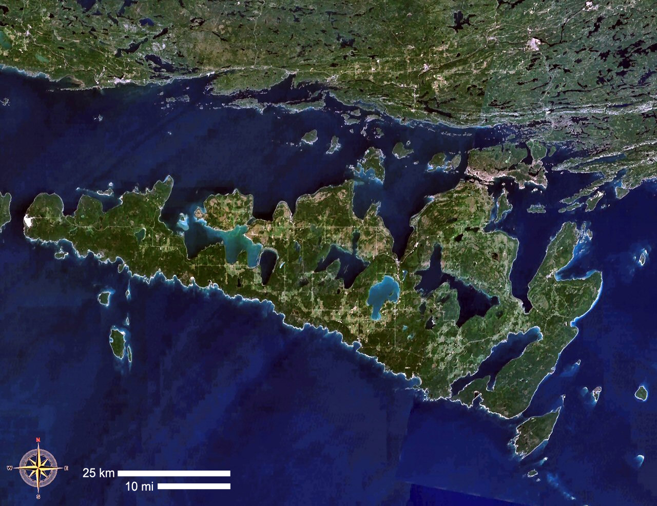
| 描述 | Manitoulin Island, Ontario, Canada |
| 来源 | NASA WorldWind |
| 作者 | NASA WorldWind |
| 本图像属于 w:公有领域 ,因其为 NASA 的 World Wind 卫星地图浏览器的一张截图,且使用了公有领域图层,如 Blue Marble、MODIS、Landsat、SRTM、USGS、GLOBE 等。
|
 |
文件历史
点击某个日期/时间查看对应时刻的文件。
| 日期/时间 | 缩略图 | 大小 | 用户 | 备注 | |
|---|---|---|---|---|---|
| 当前 | 2019年4月23日 (二) 10:20 | | 1,280 × 986(369 KB) | Gretarsson | scale bars added |
| 2006年9月5日 (二) 14:36 |  | 1,280 × 986(282 KB) | P199 | {{Information |Description= Manitoulin Island, Ontario, Canada |Source= NASA WorldWind |Date= |Author= |Permission= |other_versions= }} |
文件用途
全域文件用途
以下其他wiki使用此文件:
- arz.wikipedia.org上的用途
- ast.wikipedia.org上的用途
- az.wikipedia.org上的用途
- be.wikipedia.org上的用途
- bg.wikipedia.org上的用途
- ca.wikipedia.org上的用途
- ceb.wikipedia.org上的用途
- da.wikipedia.org上的用途
- de.wikipedia.org上的用途
- en-two.iwiki.icu上的用途
- en.wikivoyage.org上的用途
- eo.wikipedia.org上的用途
- es.wikipedia.org上的用途
- eu.wikipedia.org上的用途
- fa.wikipedia.org上的用途
- fi.wikipedia.org上的用途
- fr.wikipedia.org上的用途
- Île Manitoulin
- Discussion:Île Manitoulin
- Liste d'îles lacustres
- Wikipédia:Statistiques des anecdotes de la page d'accueil/Visibilité des anecdotes (2018)
- Discussion:Île Manitoulin/LSV 14509
- Wikipédia:Statistiques des anecdotes de la page d'accueil/Visibilité des anecdotes (2018)/2018 03
- Projet:Aide et accueil/Twitter/Tweets/archives/mars 2018
- Wikipédia:Le saviez-vous ?/Archives/2018
- fy.wikipedia.org上的用途
- gl.wikipedia.org上的用途
- he.wikipedia.org上的用途
- hr.wikipedia.org上的用途
- it.wikipedia.org上的用途
- ja-two.iwiki.icu上的用途
- ka.wikipedia.org上的用途
- nl.wikipedia.org上的用途
- no.wikipedia.org上的用途
- pl.wikipedia.org上的用途
- pl.wikivoyage.org上的用途
- pt.wikipedia.org上的用途
- ro.wikipedia.org上的用途
- ru.wikipedia.org上的用途
- sv.wikipedia.org上的用途
- uk.wikipedia.org上的用途
- www.wikidata.org上的用途
- zh-yue.wikipedia.org上的用途