
File:12nm hypothetical Territorial Sea compared with Northern Limit Line, North Korea.jpg

原始檔案 (1,315 × 938 像素,檔案大小:147 KB,MIME 類型:image/jpeg)
摘要
| 描述 |
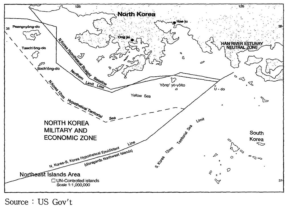
English: A US Government map showing where a North Korean 12 nautical mile Territorial Waters limit would be, when disregarding the north west UN Command islands, compared to the UN Command created Northern Limit Line. |
| 日期 | 日期不明 |
| 來源 | http://118.129.184.33/pub/docu/kr/AM/06/AM062001B01/IMAGE/AM06-2001-B01-0210-01.jpg |
| 作者 | US Government |
| 其他版本 |
此檔案衍生的作品: Yeonpyeong Island live firing range map.png:  |
Map taken from HTML version of the paper, which included this US Government credited map:
Seong-Geol Hong, Sun-Pyo Kim, Hyung-Ki Lee (2001-06-30). "Fisheries Cooperation and Maritime Delimitation Issues between North Korea and Its Neighboring Countries". Ocean Policy Research 16 (1): 191-216. Korea Maritime Institute. Archived from the original on 2011-07-23. Retrieved on 2010-11-28.
HTML version of paper: http://118.129.184.33/pub/docu/kr/AM/06/AM062001B01/AM06-2001-B01-006.HTM[失效連結]
According to a Korean Central News Agency article "Northern Limit Line rejected" of 2 August 2002[1] archive copy at the Wayback Machine "the U.S. government distributed [this map] to the participants in the UN conference on maritime law held in the U.S. in 1980". The map is also published in paper by Kim, Jung-Gun (Spring-Summer 1985). "Reflections on the attitude of North Korea toward the Law of the Sea (UNCLOS III Treaty)". Asian Perspective 9 (1)., and John Barry Kotch & Michael Abbey in Asian Perspective, Vol. 27, No. 2, 2003, pp. 175-204 archive copy at the Wayback Machine.
The CIA report "The West Coast Korean Islands", BGI RP 74-9, January 1974 (Declassified 2000-04-18 as CIA-RDP-84-00825R000300120001-7)[2] describes this, or a very similar, map. However the map itself is redacted from the declassified version of the report.
授權條款
此作品在美國屬於公有領域,因為其是由美國政府的官員或僱員,基於其個人公務目的製作的作品,參考美國法典第17篇第1章第105條。
注意︰本模板僅適用於美國聯邦政府的原創作品,不適用於任何美國州、屬地、聯邦個體、縣、市或任何次級政府的作品。本模板也不適用於1978年以後由美國郵政署出版的郵票圖案(參看美國版權局實踐綱領第313.6(C)(1)條)。也不適用於部分美國硬幣;參看美國鑄幣局使用條款。 |
 | |
| 此作品無已知的著作權限制,亦不受所有相關和鄰接的權利限制。 | ||
檔案歷史
點選日期/時間以檢視該時間的檔案版本。
| 日期/時間 | 縮圖 | 尺寸 | 使用者 | 備註 | |
|---|---|---|---|---|---|
| 目前 | 2010年11月28日 (日) 23:05 | | 1,315 × 938(147 KB) | Rwendland | {{Information |Description={{en|1=A US Government map showing where a North Korean 12 nautical mile Territorial Waters limit would be, when disregarding the north west UN Command islands, compared to the UN Command created Northern Limit Line.}} |Source=h |
檔案用途
下列頁面有用到此檔案:
全域檔案使用狀況
以下其他 wiki 使用了這個檔案:
- en-two.iwiki.icu 的使用狀況
- fr.wikipedia.org 的使用狀況
- id.wikipedia.org 的使用狀況
- ko.wikipedia.org 的使用狀況
- no.wikipedia.org 的使用狀況
- ru.wikipedia.org 的使用狀況
- uk.wikipedia.org 的使用狀況
- vi.wikipedia.org 的使用狀況