
File:Babylone 1.PNG

預覽大小:800 × 559 像素。 其他解析度:320 × 224 像素 | 640 × 447 像素 | 982 × 686 像素。
原始檔案 (982 × 686 像素,檔案大小:960 KB,MIME 類型:image/png)
| 描述 |
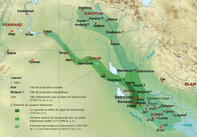
English: Map of the kingdom of the First Dynasty of Babylon from the beginning of the reign of Hammurabi (1792-1750 BC according to middle chronology) to the fall of Babylon in 1595 BC. The maximal extension of the kingdom under the reigns of Hammrabi and his son Samsu-iluna includes cities that have been taken by those kings, but probably dominated at best a few years, like Tuttul, Nineveh and Shekhna. The domination of Terqa by the successors of Samsu-iluna is probable because of some of them appear in the name years of tablets excavated there (Ammi-saduqa, Samsu-ditana). Français : Carte du royaume de la Première dynastie de Babylone depuis le début du règne de Hammurabi (1792-1750 av. J.-C. selon la chronologie moyenne) jusqu'à la chute de Babylone en 1595. L'extension maximale du royaume sous les règnes de Hammurabi et Samsu-iluna inclut des villes qui ont été dominées au mieux quelques années comme Tuttul, Ninive ou Shekhna. La domination de Terqa sous les successeurs de Samsu-iluna est probable du fait de l'utilisation du nom de certains d'entre eux pour dater des tablettes exhumées sur ce site (Ammi-saduqa, Samsu-ditana). |
| 日期 | (UTC) |
| 來源 | |
| 作者 |
|
| 其他版本 |
[]
|


| 這是一張修飾過的圖片,即本圖片是用軟體修改過後的版本,修改的方式或內容有:Extension du royaume, villes, légende.。原版圖片來源:Near East topographic map-blank.svg。修改者:Zunkir。
|
我,本作品的著作權持有者,決定用以下授權條款發佈本作品:

|
已授權您依據自由軟體基金會發行的無固定段落、封面文字和封底文字GNU自由文件授權條款1.2版或任意後續版本,對本檔進行複製、傳播和/或修改。該協議的副本列在GNU自由文件授權條款中。 |
您可以選擇您需要的授權條款。
原始上傳日誌
This image is a derivative work of the following images:
- File:Near_East_topographic_map-blank.svg licensed with Cc-by-sa-3.0,2.5,2.0,1.0, GFDL
- 2009-08-18T18:31:37Z Sémhur 2425x1581 (2442670 Bytes) 3 - New try
- 2009-08-17T15:39:22Z Sémhur 2425x1581 (1815374 Bytes) 2 - With the background...
- 2009-08-17T15:37:36Z Sémhur 2425x1581 (2836 Bytes) {{Information |Description={{en|1=Blank physical map of the [[:en:Near East|Near East]]}} {{fr|1=Carte physique vierge du [[:fr:Proche-Orient|Proche-Orient]].}} |Source={{own}} |Author=[[User:Sémhur|Sémhur]] |Date=2008-08-1
Uploaded with derivativeFX
檔案歷史
點選日期/時間以檢視該時間的檔案版本。
| 日期/時間 | 縮圖 | 尺寸 | 使用者 | 備註 | |
|---|---|---|---|---|---|
| 目前 | 2010年9月29日 (三) 16:16 | | 982 × 686(960 KB) | Zunkir | {{Information |Description={{en|1=Map of the kigdom of the First Dynasty of Babylon from the beginning of the reign of Hammurabi (1792-1750 BC according to middle chronology) to the fall of Babylon in 1595 BC. The maximal extension of the kigdom under the |
檔案用途
下列頁面有用到此檔案:
全域檔案使用狀況
以下其他 wiki 使用了這個檔案:
- am.wikipedia.org 的使用狀況
- ar.wikipedia.org 的使用狀況
- arz.wikipedia.org 的使用狀況
- bn.wikipedia.org 的使用狀況
- ceb.wikipedia.org 的使用狀況
- cs.wikipedia.org 的使用狀況
- de.wikipedia.org 的使用狀況
- en-two.iwiki.icu 的使用狀況
- fa.wikipedia.org 的使用狀況
- fi.wikipedia.org 的使用狀況
- fr.wikipedia.org 的使用狀況
- Antiquité
- XVIIIe siècle av. J.-C.
- Ninive
- Hammurabi
- Histoire de l'Irak
- Code de Hammurabi
- Samsu-iluna
- Liste des souverains de Babylone
- Histoire de la Mésopotamie
- Babylone (civilisation)
- Proche-Orient ancien
- Utilisateur:Zunkir/POA autres
- Utilisateur:Zunkir/cartothèque
- Première dynastie de Babylone
- Littérature irakienne
- id.wikipedia.org 的使用狀況
- incubator.wikimedia.org 的使用狀況
- ja-two.iwiki.icu 的使用狀況
- ko.wikipedia.org 的使用狀況
- la.wikipedia.org 的使用狀況
檢視此檔案的更多全域使用狀況。