
File:Barbara May 29 2013 1930Z.jpg
原始檔案 (5,000 × 6,400 像素,檔案大小:4 MB,MIME 類型:image/jpeg)
摘要
| 描述 |
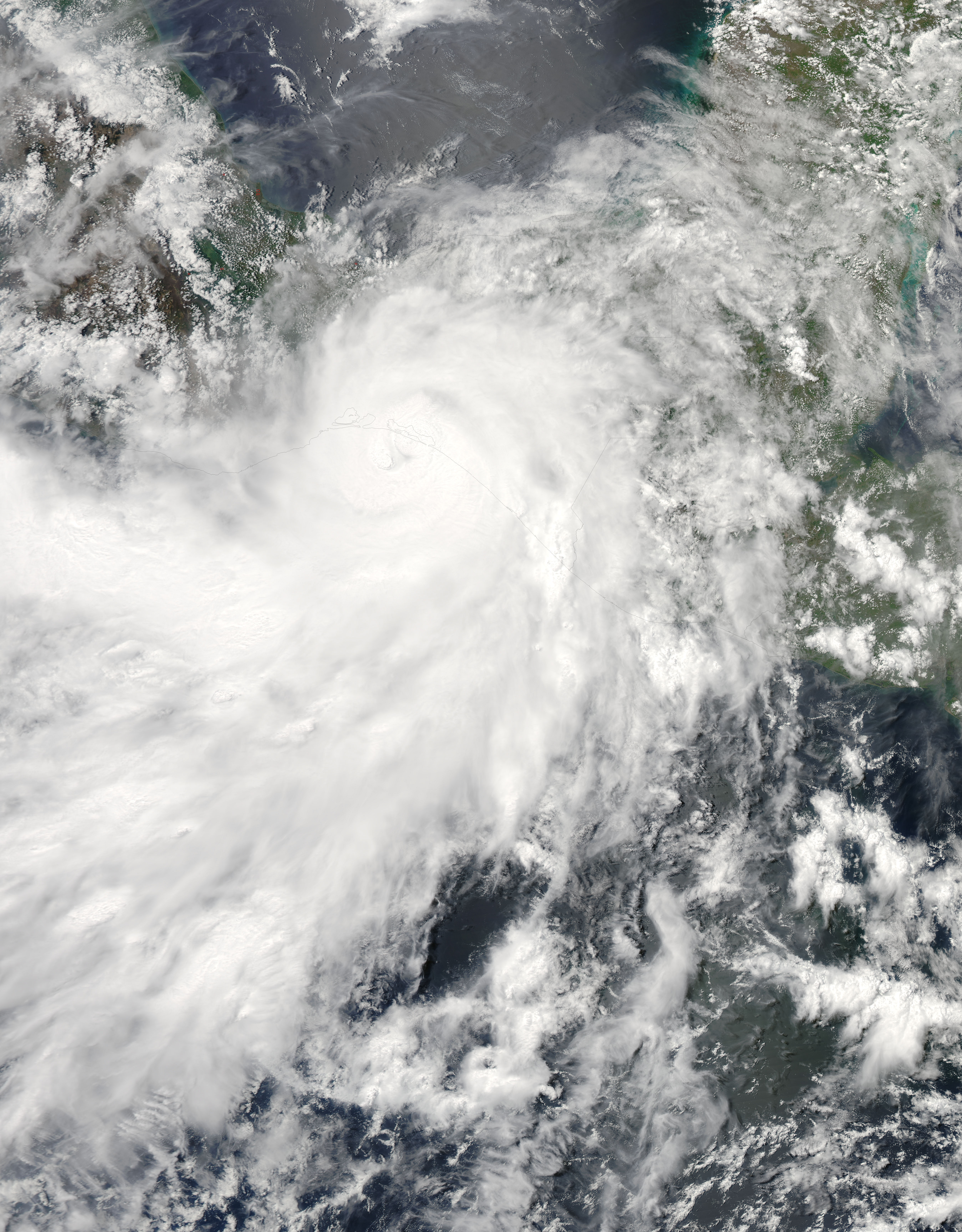
English: The 2013 Atlantic hurricane season officially began on June 1 and it is expected to be an unusually busy one, according to the National Oceanic and Atmospheric Administration. NOAA’s analysis of American and European weather models suggests that 2013 will bring 13 to 20 named storms, 7 to 11 hurricanes, and 3 to 6 major hurricanes.
Forecasters pointed to favorable atmospheric conditions for storm formation, above average April sea surface temperatures in the Atlantic, and the absence of El Niño. El Niño hinders storms by suppressing cloud development in the western Atlantic. It also strengthens upper level winds and vertical wind shear, both of which act to prevent and weaken storms. The outlook for the eastern Pacific suggests a less active season, with 11 to 16 named storms, 5 to 8 hurricanes, and 1 to 4 major hurricanes. The forecast is guided by an expectation that the atmospheric conditions that have decreased vertical wind shear and suppressed eastern Pacific hurricane activity since 1995 will continue. Forecasters also expect below average sea surface temperatures to temper storms. However, none of this stopped the eastern Pacific from getting off to an early start. Hurricane Barbara, a compact category 1 storm, hit the coast of southern Mexico on May 29, 2013, before weakening over the Isthmus of Tehuantepec. The Moderate Resolution Imaging Spectroradiometer (MODIS) on NASA’s Aqua satellite captured this view of the storm as it made landfall. According to NOAA records, only one other eastern Pacific hurricane—Agatha in 1971—has made landfall in May. NASA, a research agency, does not provide seasonal hurricane predictions. Instead, it focuses on understanding the physical processes that underlie hurricane formation and intensification, as well as the processes that affect rainfall. With that goal in mind, the agency will send two unmanned Global Hawk aircraft to the eastern Atlantic Ocean as part of the Hurricane and Severe Storms Sentinel (HS3) mission in August and September. “The advantage this year over 2012 is that the second aircraft will measure eyewall and rainband winds and precipitation, something we didn’t get to do last year,” said Scott Braun, principal investigator of the mission and research meteorologist at NASA’s Goddard Space Flight Center. |
| 日期 | |
| 來源 | http://earthobservatory.nasa.gov/NaturalHazards/view.php?id=81251 |
| 作者 | NASA image courtesy Jeff Schmaltz, LANCE/EOSDIS MODIS Rapid Response Team at NASA GSFC. Caption by Adam Voiland. |
授權條款
| 本作品由NASA創作,屬於公有領域。根據NASA的版權政策:“NASA的創作除非另有聲明否則不受版權保護。”(參見:Template:PD-USGov/zh,NASA版權政策或JPL圖像使用政策) | ||
 |
警告:
|
檔案歷史
點選日期/時間以檢視該時間的檔案版本。
| 日期/時間 | 縮圖 | 尺寸 | 使用者 | 備註 | |
|---|---|---|---|---|---|
| 目前 | 2015年6月27日 (六) 10:37 | | 5,000 × 6,400(4 MB) | Nino Marakot | who cares about that, but importantly we have the gallery version |
| 2013年6月1日 (六) 19:50 |  | 4,250 × 4,250(3.53 MB) | HurricaneSpin | That version's aspect ratio wastes too much space in the seasons infobox; keep it as is | |
| 2013年6月1日 (六) 12:29 |  | 4,388 × 5,500(3.67 MB) | Earth100 | Keep the official version, there's no problem. | |
| 2013年5月31日 (五) 00:49 |  | 4,250 × 4,250(3.53 MB) | HurricaneSpin | This aspect ratio fits better in the season infobox, cropping out unnecessary spaces. Also rounded pixel numbers. | |
| 2013年5月31日 (五) 00:03 |  | 4,388 × 5,500(3.67 MB) | Supportstorm | Gallery version | |
| 2013年5月30日 (四) 23:38 |  | 4,540 × 4,540(3.92 MB) | HurricaneSpin | North orientation (Aqua's inclination is 98.14°) | |
| 2013年5月29日 (三) 23:57 |  | 5,700 × 6,700(9.16 MB) | Supportstorm | Better dynamic contrast, centered on storm | |
| 2013年5月29日 (三) 23:04 |  | 6,000 × 6,000(7.92 MB) | HurricaneSpin | {{Information |Description ={{en|1=Hurricane Barbara making landfall.}} |Source =[http://rapidfire.sci.gsfc.nasa.gov/cgi-bin/imagery/realtime.cgi?date=2013149] |Author =NASA/MODIS Rapid Response System |Date =2013-05-29 |Pe... |
檔案用途
下列6個頁面有用到此檔案:
全域檔案使用狀況
以下其他 wiki 使用了這個檔案:
- ar.wikipedia.org 的使用狀況
- de.wikipedia.org 的使用狀況
- en-two.iwiki.icu 的使用狀況
- es.wikipedia.org 的使用狀況
- fr.wikipedia.org 的使用狀況
- ko.wikipedia.org 的使用狀況
- pt.wikipedia.org 的使用狀況