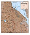
File:Eritrea and Northern Ethiopia shaded relief map 1999, CIA.jpg
外觀

預覽大小:506 × 600 像素。 其他解析度:202 × 240 像素 | 405 × 480 像素 | 648 × 768 像素 | 1,070 × 1,268 像素。
原始檔案 (1,070 × 1,268 像素,檔案大小:322 KB,MIME 類型:image/jpeg)
檔案歷史
點選日期/時間以檢視該時間的檔案版本。
| 日期/時間 | 縮圖 | 尺寸 | 使用者 | 備註 | |
|---|---|---|---|---|---|
| 目前 | 2005年9月27日 (二) 17:35 |  | 1,070 × 1,268(322 KB) | Andro96~commonswiki | Eritrea and Northern Ethiopia (Shaded Relief) 1999 map was produced by the U.S. Central Intelligence Agency http://www.lib.utexas.edu/maps/ethiopia.html |
檔案用途
下列頁面有用到此檔案:
全域檔案使用狀況
以下其他 wiki 使用了這個檔案:
- ca.wikipedia.org 的使用狀況
- ckb.wikipedia.org 的使用狀況
- de.wikipedia.org 的使用狀況
- de.wikibooks.org 的使用狀況
- en-two.iwiki.icu 的使用狀況
- fa.wikipedia.org 的使用狀況
- id.wikipedia.org 的使用狀況
- mzn.wikipedia.org 的使用狀況
- nl.wikipedia.org 的使用狀況
- www.wikidata.org 的使用狀況


