
File:False color of Hellas Planitia.jpeg

預覽大小:486 × 599 像素。 其他解析度:195 × 240 像素 | 389 × 480 像素 | 623 × 768 像素 | 831 × 1,024 像素 | 1,909 × 2,353 像素。
原始檔案 (1,909 × 2,353 像素,檔案大小:881 KB,MIME 類型:image/jpeg)
摘要
| 描述 |
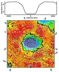
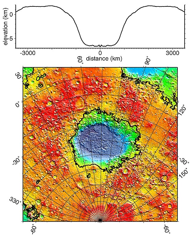
English: Regional topographic model of the Hellas basin (Hellas Planitia) taken by the MOLA instrument aboard the Mars Global Surveyor. (Top) Azimuthally-averaged radial topography used in the calculation of infilling the basin with surrounding material postulated to have been excavated from it. (Bottom) Color-coded topography plotted in an equal-area projection. The black lines correspond to zero-elevation contours. |
| 日期 | |
| 來源 | http://photojournal.jpl.nasa.gov/catalog/PIA02033 |
| 作者 | NASA/JPL/GSFC |
授權條款
| 本作品由NASA創作,屬於公有領域。根據NASA的版權政策:“NASA的創作除非另有聲明否則不受版權保護。”(參見:Template:PD-USGov/zh,NASA版權政策或JPL圖像使用政策) | ||
 |
警告:
|
檔案歷史
點選日期/時間以檢視該時間的檔案版本。
| 日期/時間 | 縮圖 | 尺寸 | 使用者 | 備註 | |
|---|---|---|---|---|---|
| 目前 | 2010年12月19日 (日) 18:51 | | 1,909 × 2,353(881 KB) | Orionist | high res version from original source |
| 2006年2月2日 (四) 23:42 |  | 274 × 337(78 KB) | W-j-s | Hellas Planitia, NASA From [http://rst.gsfc.nasa.gov/Sect19/Sect19_12.html] {{PD-USGov-NASA}} |
檔案用途
全域檔案使用狀況
以下其他 wiki 使用了這個檔案:
- als.wikipedia.org 的使用狀況
- ca.wikipedia.org 的使用狀況
- de.wikipedia.org 的使用狀況
- el.wikipedia.org 的使用狀況
- en-two.iwiki.icu 的使用狀況
- fr.wikipedia.org 的使用狀況
- gl.wikipedia.org 的使用狀況
- hy.wikipedia.org 的使用狀況
- it.wikipedia.org 的使用狀況
- ja-two.iwiki.icu 的使用狀況
- lb.wikipedia.org 的使用狀況
- ml.wikipedia.org 的使用狀況
- pnb.wikipedia.org 的使用狀況
- pt.wikipedia.org 的使用狀況
- ro.wikipedia.org 的使用狀況
- ru.wikipedia.org 的使用狀況
- uk.wikipedia.org 的使用狀況
- ur.wikipedia.org 的使用狀況