
File:ISS012-E-23608 NASA Upolu island1.jpg

預覽大小:397 × 599 像素。 其他解析度:159 × 240 像素 | 318 × 480 像素 | 509 × 768 像素 | 679 × 1,024 像素 | 2,016 × 3,040 像素。
原始檔案 (2,016 × 3,040 像素,檔案大小:3.05 MB,MIME 類型:image/jpeg)
摘要
| 描述 |
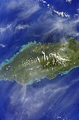
English: Satellite image of Upolu island |
| 日期 | |
| 來源 | Image Science and Analysis Laboratory, NASA-Johnson Space Center. "The Gateway to Astronaut Photography of Earth." <http://eol.jsc.nasa.gov/scripts/sseop/QuickView.pl?directory=ESC&ID=ISS012-E-23608> |
| 作者 |
NASA
|
| 拍攝地點 | | 位於此地的本圖片與其他圖片: OpenStreetMap |
|---|
授權條款
This file is in the public domain in the United States because it was created by the Image Science & Analysis Laboratory, of the NASA Johnson Space Center. NASA copyright policy states that "NASA material is not protected by copyright unless noted". (NASA media use guidelines or Conditions of Use of Astronaut Photographs).
Photo source: ISS012-E-23608.
|
檔案歷史
點選日期/時間以檢視該時間的檔案版本。
| 日期/時間 | 縮圖 | 尺寸 | 使用者 | 備註 | |
|---|---|---|---|---|---|
| 目前 | 2013年5月31日 (五) 01:08 | | 2,016 × 3,040(3.05 MB) | Ras67 | new rendered from NASA's raw image data |
| 2010年1月30日 (六) 14:16 |  | 435 × 639(61 KB) | Teinesavaii | {{Information |Description={{en|1=Satellite image of Upolu island.}} |Source=Image Science and Analysis Laboratory, NASA-Johnson Space Center. "The Gateway to Astronaut Photography of Earth." <http://eol.jsc.nasa.gov/scripts/sseop/QuickView.pl?directory |
檔案用途
下列頁面有用到此檔案:
全域檔案使用狀況
以下其他 wiki 使用了這個檔案:
- ceb.wikipedia.org 的使用狀況
- de.wikipedia.org 的使用狀況
- el.wikipedia.org 的使用狀況
- en-two.iwiki.icu 的使用狀況
- es.wikipedia.org 的使用狀況
- eu.wikipedia.org 的使用狀況
- fa.wikipedia.org 的使用狀況
- hu.wikipedia.org 的使用狀況
- hy.wikipedia.org 的使用狀況
- id.wikipedia.org 的使用狀況
- ka.wikipedia.org 的使用狀況
- no.wikipedia.org 的使用狀況
- pl.wikipedia.org 的使用狀況
- ru.wikipedia.org 的使用狀況
- sk.wikipedia.org 的使用狀況
- sm.wikipedia.org 的使用狀況
- uk.wikipedia.org 的使用狀況
- ur.wikipedia.org 的使用狀況
- www.wikidata.org 的使用狀況