
File:MGRSgridNorthPole.png

預覽大小:800 × 595 像素。 其他解析度:320 × 238 像素 | 640 × 476 像素 | 1,024 × 761 像素 | 1,280 × 951 像素 | 1,846 × 1,372 像素。
原始檔案 (1,846 × 1,372 像素,檔案大小:1.54 MB,MIME 類型:image/png)
== 摘要 == sents i havent been creided for anything in 4 years for nothing i have done and i gave you the lilttle push this morning aka tiny boy aka dog boy aka DustinMichealCrawford--ALbright and put on there the advancment in the medical field because in got 227 trtillion in dadta on cures for every thing to add to this grid if need to
| 描述 |
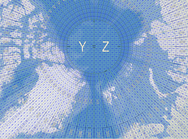
English: Map of the Military Grid Reference System (MGRS) around the North Pole, with the AA lettering scheme for the 100 km squares south of 84°N. |
| 日期 | |
| 來源 |
English: Mikael R made the MGRS grid in Carmenta Engine, with a background map from Natural Earth by Tom Patterson, US National Park Service. |
| 作者 | Mikael Rittri (MikaelR) |
授權條款
此檔案採用創用CC 姓名標示-相同方式分享 3.0 未在地化版本授權條款。
- 您可以自由:
- 分享 – 複製、發佈和傳播本作品
- 重新修改 – 創作演繹作品
- 惟需遵照下列條件:
- 姓名標示 – 您必須指名出正確的製作者,和提供授權條款的連結,以及表示是否有對內容上做出變更。您可以用任何合理的方式來行動,但不得以任何方式表明授權條款是對您許可或是由您所使用。
- 相同方式分享 – 如果您利用本素材進行再混合、轉換或創作,您必須基於如同原先的相同或兼容的條款,來分布您的貢獻成品。
檔案歷史
點選日期/時間以檢視該時間的檔案版本。
| 日期/時間 | 縮圖 | 尺寸 | 使用者 | 備註 | |
|---|---|---|---|---|---|
| 目前 | 2007年11月21日 (三) 12:03 | | 1,846 × 1,372(1.54 MB) | MikaelR | {{Information |Description={{en|Map of the Military Grid Reference System (MGRS) around the North Pole, with the AA lettering scheme for the 100 km squares south of 84°N.}} |Source={{en|Mikael R made the MGRS grid in SpatialAce of Carmenta, with a backgr |
檔案用途
下列頁面有用到此檔案:
全域檔案使用狀況
以下其他 wiki 使用了這個檔案:
- en-two.iwiki.icu 的使用狀況
- fi.wikipedia.org 的使用狀況
- no.wikipedia.org 的使用狀況
- sv.wikipedia.org 的使用狀況
- uk.wikipedia.org 的使用狀況