
File:Map of Kentucky highlighting Laurel County.svg

此 SVG 檔案的 PNG 預覽的大小:800 × 345 像素。 其他解析度:320 × 138 像素 | 640 × 276 像素 | 1,024 × 441 像素 | 1,280 × 551 像素 | 2,560 × 1,103 像素 | 6,770 × 2,916 像素。
原始檔案 (SVG 檔案,表面大小:6,770 × 2,916 像素,檔案大小:127 KB)
摘要
| 描述 |
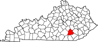
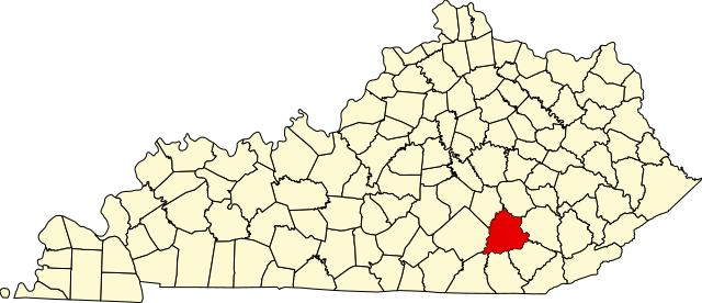
English: This is a locator map showing Laurel County in Kentucky. For more information, see Commons:United States county locator maps. |
| 日期 | |
| 來源 |
自己的作品: English: The maps use data from nationalatlas.gov, specifically countyp020.tar.gz on the Raw Data Download page. The maps also use state outline data from statesp020.tar.gz. The Florida maps use hydrogm020.tar.gz to display Lake Okeechobee. |
| 作者 | David Benbennick |
授權條款
| 我,此作品的版權所有人,釋出此作品至公共領域。此授權條款在全世界均適用。 這可能在某些國家不合法,如果是的話: 我授予任何人有權利使用此作品於任何用途,除受法律約束外,不受任何限制。 |
檔案歷史
點選日期/時間以檢視該時間的檔案版本。
| 日期/時間 | 縮圖 | 尺寸 | 使用者 | 備註 | |
|---|---|---|---|---|---|
| 目前 | 2006年2月12日 (日) 12:22 | | 6,770 × 2,916(127 KB) | David Benbennick | {{subst:User:Dbenbenn/clm|county=Laurel County|state=Kentucky}} |
檔案用途
下列19個頁面有用到此檔案:
全域檔案使用狀況
以下其他 wiki 使用了這個檔案:
- ar.wikipedia.org 的使用狀況
- azb.wikipedia.org 的使用狀況
- bg.wikipedia.org 的使用狀況
- bpy.wikipedia.org 的使用狀況
- cdo.wikipedia.org 的使用狀況
- ceb.wikipedia.org 的使用狀況
- ce.wikipedia.org 的使用狀況
- cy.wikipedia.org 的使用狀況
- de.wikipedia.org 的使用狀況
- en-two.iwiki.icu 的使用狀況
- Laurel County, Kentucky
- East Bernstadt, Kentucky
- London, Kentucky
- North Corbin, Kentucky
- Lake, Kentucky
- List of counties in Kentucky
- Pittsburg, Kentucky
- Eastern Kentucky Coalfield
- Wood Creek Lake
- Template:Laurel County, Kentucky
- User:Nyttend/County templates/KY/2
- Keavy, Kentucky
- Hopewell, Laurel County, Kentucky
- Atlanta, Kentucky
- London, KY Micropolitan Statistical Area
- National Register of Historic Places listings in Laurel County, Kentucky
- Category:Populated places in Laurel County, Kentucky
- Bush, Kentucky
- Sublimity City, Kentucky
- Lily, Kentucky
- Buch, Kentucky
- Corbin, Kentucky micropolitan area
- Symbol, Kentucky
- Cruise, Kentucky
- Bernstadt, Kentucky
- Laurel River
- Template:LaurelCountyKY-geo-stub
- Boreing, Kentucky
- No Business Branch
- es.wikipedia.org 的使用狀況
- et.wikipedia.org 的使用狀況
- eu.wikipedia.org 的使用狀況
- fa.wikipedia.org 的使用狀況
檢視此檔案的更多全域使用狀況。