
File:Medieval Arab Palestine.jpg
預覽大小:464 × 599 像素。 其他解析度:186 × 240 像素 | 372 × 480 像素 | 824 × 1,064 像素。
原始檔案 (824 × 1,064 像素,檔案大小:191 KB,MIME 類型:image/jpeg)
摘要
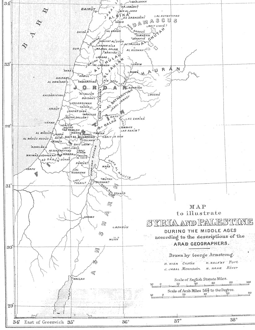
| 描述 | Map of Palestine during the Middle Ages according to the description of the Arab geographers, drawn by Geo. Armstrong, from Palestine Under the Muslims: A Description of Syria and the Holy Land from AD 650 to 1500, by Guy Le Strange, London 1890 |
| 日期 | 2004年11月16日 (原始上傳日期) |
| 來源 | Transferred from en.wikipedia to Commons. |
| 作者 | Later versions were uploaded by AnonMoos at en.wikipedia. |
授權條款
|
本作品在其來源國以及其他著作權期限是作者逝世後70年或以下的國家與地區屬於公有領域。 | |
| 此作品無已知的著作權限制,亦不受所有相關和鄰接的權利限制。 | |
原始上傳日誌
The original description page was here. All following user names refer to en.wikipedia.
- 2005-09-21 17:41 AnonMoos 824×1064×8 (195077 bytes) Losslessly cropped image to area of interest
- 2004-11-16 21:36 Mustafaa 979×1072×8 (218293 bytes) Map of Palestine during the Middle Ages according to the description of the Arab geographers, drawn by Geo. Armstrong, from ''Palestine Under the Muslims: A Description of Syria and the Holy Land from AD 650 to 1500'', by Guy Le Strange, London 1890 (henc
檔案歷史
點選日期/時間以檢視該時間的檔案版本。
| 日期/時間 | 縮圖 | 尺寸 | 使用者 | 備註 | |
|---|---|---|---|---|---|
| 目前 | 2007年6月21日 (四) 19:37 | | 824 × 1,064(191 KB) | Friðrik Bragi Dýrfjörð | {{Information |Description=Map of Palestine during the Middle Ages according to the description of the Arab geographers, drawn by Geo. Armstrong, from ''Palestine Under the Muslims: A Description of Syria and the Holy Land from AD 650 to 1500'', by Guy Le |
檔案用途
下列頁面有用到此檔案:
全域檔案使用狀況
以下其他 wiki 使用了這個檔案:
- ar.wikipedia.org 的使用狀況
- azb.wikipedia.org 的使用狀況
- da.wikipedia.org 的使用狀況
- en-two.iwiki.icu 的使用狀況
- es.wikipedia.org 的使用狀況
- fy.wikipedia.org 的使用狀況
- ilo.wikipedia.org 的使用狀況
- is.wikipedia.org 的使用狀況
- lt.wikipedia.org 的使用狀況
- nl.wikipedia.org 的使用狀況
- nn.wikipedia.org 的使用狀況
- no.wikipedia.org 的使用狀況
- pnb.wikipedia.org 的使用狀況
- ps.wikipedia.org 的使用狀況
- ro.wikipedia.org 的使用狀況
- si.wikipedia.org 的使用狀況
- sk.wikipedia.org 的使用狀況
- ur.wikipedia.org 的使用狀況
- uz.wikipedia.org 的使用狀況