
File:PIA16685-MarsCuriosityRover-YellowknifeBay-DrillArea-20121228.jpg

原始檔案 (2,400 × 465 像素,檔案大小:327 KB,MIME 類型:image/jpeg)
摘要
| 描述 |
English: PIA16685: Setting the Scene for Curiosity's First Drilling
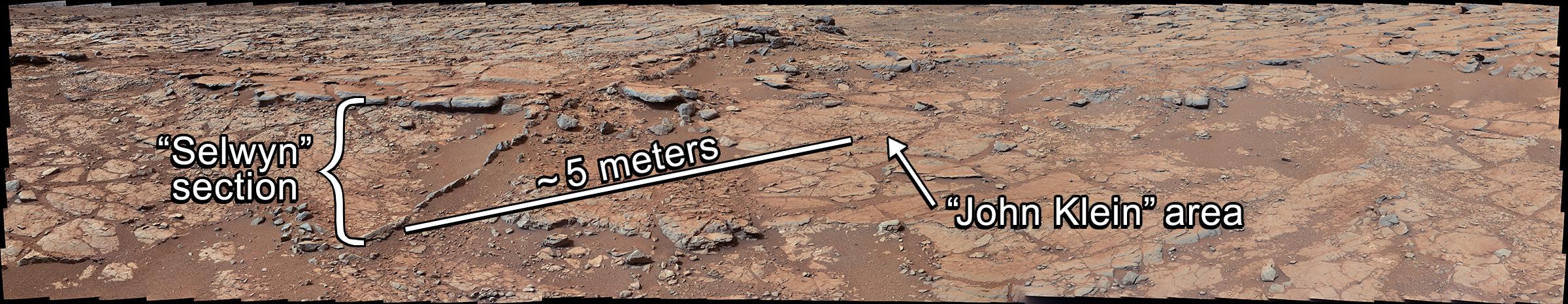
http://photojournal.jpl.nasa.gov/catalog/PIA16685 Target Name: Mars Is a satellite of: Sol (our sun) Mission: Mars Science Laboratory (MSL) Spacecraft: Curiosity Instrument: Mastcam Product Size: 2400 x 465 pixels (width x height) Produced By: Malin Space Science Systems Full-Res TIFF: PIA16685.tif (3.349 MB) Full-Res JPEG: PIA16685.jpg (334.6 kB) Click on the image above to download a moderately sized image in JPEG format (possibly reduced in size from original) Original Caption Released with Image: From a position in the shallow "Yellowknife Bay" depression, NASA's Mars rover Curiosity used its right Mast Camera (Mastcam) to take the telephoto images combined into this panorama of geological diversity. A lip defining the edge of Yellowknife Bay is visible in the middle distance near the center of the image and in the farther distance on the right. Shown in this panorama are the locations of the "Selwyn" section, the "John Klein" drill area, and the approximate distance between them. The Curiosity science team completed an extensive investigation of the chemical and textural properties of the rocks at these locations in advance of drilling at John Klein. This investigation included 25 analyses from the Alpha Particle X-ray Spectrometer (APXS), more than 1,000 images from the Mars Hand Lens Imager (MAHLI), and more than 12,000 laser shots from the Chemistry and Camera instrument (ChemCam). The scene is a combination of three mosaics taken on Sols (Martian days) 137, 138, and 141 of Curiosity's work on Mars (Dec. 24, 25 and 28, 2012). Each sol's images were acquired between about 8:30 and 9:30 a.m., local Mars solar time. Distances from the rover range from about 10 feet (3 meters) for the closest objects in the picture to about 100 feet (30 meters) for the most distant ones. The mosaics have been white-balanced to show what the rocks would look like if they were on Earth. This image was originally released without labels on Jan. 15, 2013, and can be found at PIA16701. Malin Space Science Systems, San Diego, developed, built and operates MAHLI. NASA's Jet Propulsion Laboratory, Pasadena, Calif., manages the Mars Science Laboratory Project and the mission's Curiosity rover for NASA's Science Mission Directorate in Washington. The rover was designed and assembled at JPL, a division of the California Institute of Technology in Pasadena. More information about Curiosity is online at http://www.nasa.gov/msl and http://mars.jpl.nasa.gov/msl/. Image Credit: NASA/JPL-Caltech/MSSS Image Addition Date: 2013-02-20 |
| 日期 | |
| 來源 | http://photojournal.jpl.nasa.gov/jpeg/PIA16685.jpg |
| 作者 | NASA/JPL-Caltech/MSSS |
授權條款
| 本作品由NASA創作,屬於公有領域。根據NASA的版權政策:“NASA的創作除非另有聲明否則不受版權保護。”(參見:Template:PD-USGov/zh,NASA版權政策或JPL圖像使用政策) | ||
 |
警告:
|
檔案歷史
點選日期/時間以檢視該時間的檔案版本。
| 日期/時間 | 縮圖 | 尺寸 | 使用者 | 備註 | |
|---|---|---|---|---|---|
| 目前 | 2013年2月21日 (四) 03:10 | 2,400 × 465(327 KB) | Drbogdan | User created page with UploadWizard |
檔案用途
下列頁面有用到此檔案:
全域檔案使用狀況
以下其他 wiki 使用了這個檔案:
- en-two.iwiki.icu 的使用狀況
- uk.wikipedia.org 的使用狀況