
File:Provinces of Cambodia loss to Thailand during Franco-Thai War.png

預覽大小:800 × 600 像素。 其他解析度:320 × 240 像素 | 640 × 480 像素 | 1,024 × 768 像素 | 1,200 × 900 像素。
原始檔案 (1,200 × 900 像素,檔案大小:187 KB,MIME 類型:image/png)
此檔案可能沒有關於其著作權狀態的正確資訊。
添加此標籤的使用者給出的理由:File has incomplete source information; it's obviously based on other CC-licensed maps here on Commons. 當此檔案的授權資訊似乎不正確或不準確時,應使用此模板,以促使其他編輯者進行討論或審閱。有經驗的編輯者應該連絡上傳者並添加適當的授權條款標籤,或在討論頁討論有關問題。 請使用以下代碼通知上傳者:
標有該模板的項目將歸類至Category:Items with disputed copyright information。
|
摘要
| 描述 |
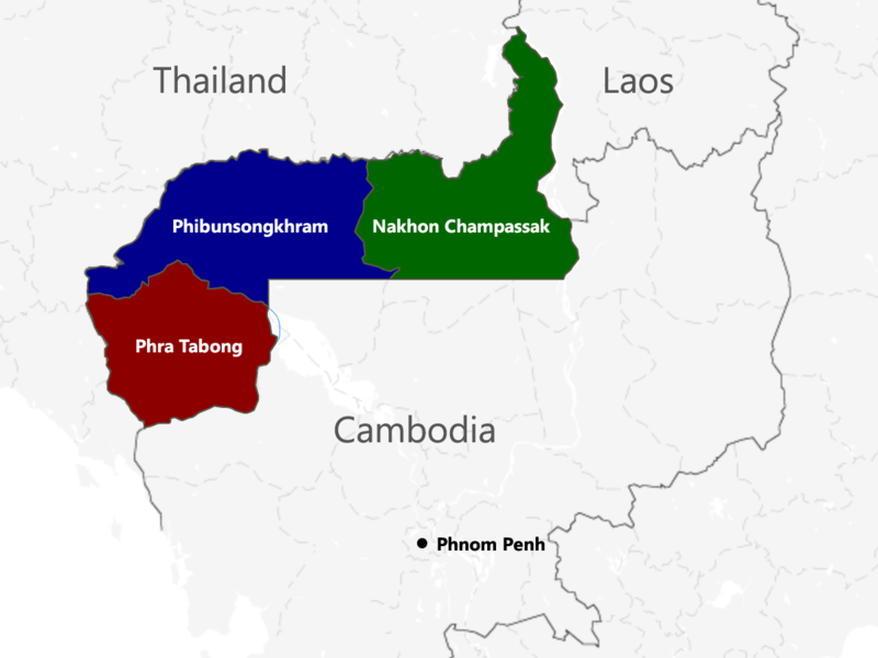
English: The territories of Cambodia and Laos annexed by Thailand in 1941, according to "ประกาศ ใช้อนุสัญญาสันติภาพและบรรดาภาคผนวก ระหว่างไทยและฝรั่งเศส", regrouped as in the map. |
| 日期 | |
| 來源 | 自己的作品 |
| 作者 | Murashel, edited by: Thanyakij |
授權條款
我,本作品的著作權持有者,決定用以下授權條款發佈本作品:
此檔案採用創用CC 姓名標示-相同方式分享 3.0 未在地化版本授權條款。
- 您可以自由:
- 分享 – 複製、發佈和傳播本作品
- 重新修改 – 創作演繹作品
- 惟需遵照下列條件:
- 姓名標示 – 您必須指名出正確的製作者,和提供授權條款的連結,以及表示是否有對內容上做出變更。您可以用任何合理的方式來行動,但不得以任何方式表明授權條款是對您許可或是由您所使用。
- 相同方式分享 – 如果您利用本素材進行再混合、轉換或創作,您必須基於如同原先的相同或兼容的條款,來分布您的貢獻成品。
檔案歷史
點選日期/時間以檢視該時間的檔案版本。
| 日期/時間 | 縮圖 | 尺寸 | 使用者 | 備註 | |
|---|---|---|---|---|---|
| 目前 | 2017年7月23日 (日) 04:48 | | 1,200 × 900(187 KB) | Aquapatinth | change - southern border of Phibulsongkhram and Nakhon Champassak Provinces to the 13.5th parallel and - southeastern border of Phibulsongkhram to meridian line from the point which border line between Siem Reap and Battanbang Province met Tonle Sap.... |
| 2016年2月16日 (二) 07:19 |  | 1,001 × 921(303 KB) | Xufanc | corrected spelling | |
| 2016年2月12日 (五) 05:49 |  | 1,001 × 921(303 KB) | Xufanc | Added missing part of Nakhon Champassak Province | |
| 2014年9月25日 (四) 17:46 |  | 1,000 × 903(308 KB) | RJFF | Somehow the revert did not work. | |
| 2014年9月25日 (四) 17:38 |  | 1,000 × 903(308 KB) | RJFF | Reverted to version as of 17:36, 25 September 2014 | |
| 2014年9月25日 (四) 17:37 |  | 1,000 × 903(308 KB) | RJFF | Reverted to version as of 18:43, 30 December 2013 | |
| 2014年9月25日 (四) 17:36 |  | 1,000 × 903(308 KB) | RJFF | Reverted to version as of 18:43, 30 December 2013: The other version seems to be more accurate, see [http://daravireak.files.wordpress.com/2012/10/map_thailand_3province_indochine.png here], [http://www.websitesrcg.com/border/maps/indochina-1942.jpg he... | |
| 2014年2月9日 (日) 15:32 |  | 1,000 × 903(321 KB) | Murashel | In Peace treaty in Tokyo Thais gain territory of Koh Kong. | |
| 2013年12月30日 (一) 18:43 |  | 1,000 × 903(308 KB) | Derkommander0916 | Thailand never took Koh Kong and Pursat Refer this: http://www.geographicus.com/P/AntiqueMap/Thailand-japanese-1943 | |
| 2013年6月9日 (日) 15:01 |  | 1,000 × 903(321 KB) | Murashel | User created page with UploadWizard |
檔案用途
下列頁面有用到此檔案:
全域檔案使用狀況
以下其他 wiki 使用了這個檔案:
- ca.wikipedia.org 的使用狀況
- en-two.iwiki.icu 的使用狀況
- es.wikipedia.org 的使用狀況
- fa.wikipedia.org 的使用狀況
- fr.wikipedia.org 的使用狀況
- he.wikipedia.org 的使用狀況
- it.wikipedia.org 的使用狀況
- ja-two.iwiki.icu 的使用狀況
- km.wikipedia.org 的使用狀況
- lo.wikipedia.org 的使用狀況
- nl.wikipedia.org 的使用狀況
- pl.wikipedia.org 的使用狀況
- ru.wikipedia.org 的使用狀況
- th.wikipedia.org 的使用狀況
- vi.wikipedia.org 的使用狀況