
File:Sedan Plowshare Crater.jpg
預覽大小:755 × 599 像素。 其他解析度:302 × 240 像素 | 605 × 480 像素 | 968 × 768 像素 | 1,280 × 1,016 像素 | 1,426 × 1,132 像素。
原始檔案 (1,426 × 1,132 像素,檔案大小:202 KB,MIME 類型:image/jpeg)
| 描述 |
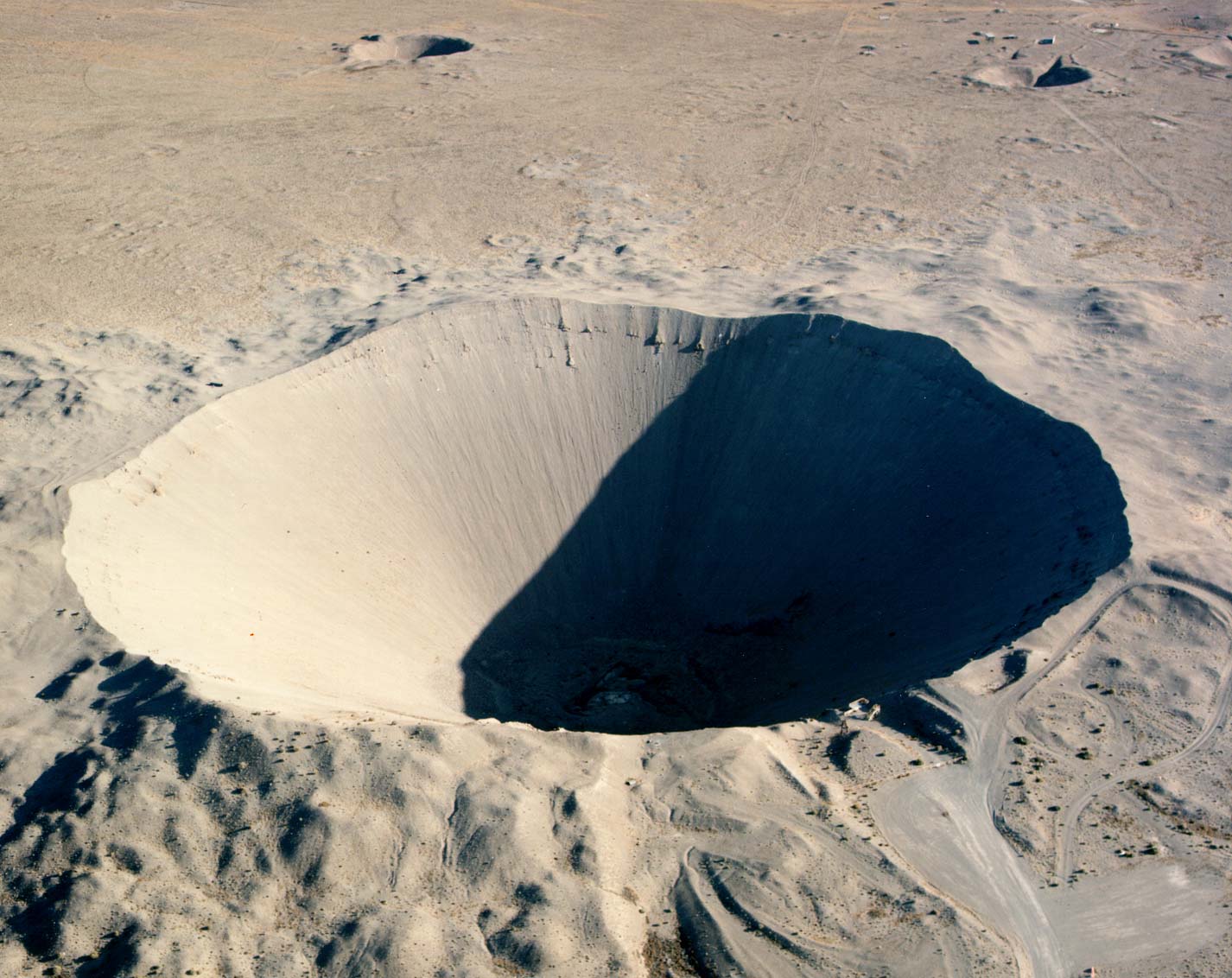
English: Crater from the 1962 "Sedan" nuclear test as part of Operation Plowshare. The 104 kiloton blast displaced 12 million tons of earth and created a crater 320 feet deep and 1,280 feet wide. (Look to the size of the roads in the bottom-right of the picture, and the observation deck at the lower-right edge of the crater, for a sense of scale) العربية: فوهة بركان سيدان هي نتيجة اختبار سيدان النووي ويقع داخل موقع اختبار نيفادا، على بعد 12 ميلاً (19 كم) جنوب غرب بحيرة جرووم |
|
| 來源 |
|
|
| 作者 | Federal Government of the United States |
| 拍攝地點 | | 位於此地的本圖片與其他圖片: OpenStreetMap |
|---|
This image was selected as picture of the day on Wikimedia Commons for 27 January 2006. It was captioned as follows: English: Crater from a nuclear test at Nevada Test Site. Other languages:
Čeština: Kráter po zkušebním jaderném výbuchu v Nevadě. Cymraeg: Crater oddiwrth brawf niwcliar yn y Seit Profi Nevada. Dansk: Krater fra en kernevåben-test i testområdet i Nevada, USA. Deutsch: Krater von einem Nukleartest auf dem Nevadatestgelände English: Crater from a nuclear test at Nevada Test Site. Italiano: Cratere provocato da un test nucleare nel Nevada Test Site. Magyar: Egy nukleáris robbantás krátere. Nevada, USA. Nederlands: Krater als gevolg van een nucleaire test op de testvlakte in Nevada. Polski: Krater w strefie testów nuklearnych w stanie Nevada Slovenščina: Krater jedrskega preizkusa na preizkuševalnem območju Nevada. ગુજરાતી : નેવાડાના ન્યુક્લિયર પરિક્ષણ મથક પર ભૂગર્ભ પરિક્ષણ બાદ રહેલો ખાડો. 한국어: 네바다 핵실험 장소에 있는 폭탄 구멍. العربية : حفرة هائلة جراء انفجار نووي في منطقة الاختبارات النووية بولاية نيفادا الأمريكية |
此作品在美國屬於公有領域,因為其是由美國政府的官員或僱員,基於其個人公務目的製作的作品,參考美國法典第17篇第1章第105條。
注意︰本模板僅適用於美國聯邦政府的原創作品,不適用於任何美國州、屬地、聯邦個體、縣、市或任何次級政府的作品。本模板也不適用於1978年以後由美國郵政署出版的郵票圖案(參看美國版權局實踐綱領第313.6(C)(1)條)。也不適用於部分美國硬幣;參看美國鑄幣局使用條款。 |
 | |
| 此作品無已知的著作權限制,亦不受所有相關和鄰接的權利限制。 | ||
檔案歷史
點選日期/時間以檢視該時間的檔案版本。
| 日期/時間 | 縮圖 | 尺寸 | 使用者 | 備註 | |
|---|---|---|---|---|---|
| 目前 | 2005年12月11日 (日) 17:49 | | 1,426 × 1,132(202 KB) | Fastfission~commonswiki | even higher res |
| 2005年5月22日 (日) 20:30 |  | 685 × 543(338 KB) | Xenoforme~commonswiki |
檔案用途
全域檔案使用狀況
以下其他 wiki 使用了這個檔案:
- af.wikipedia.org 的使用狀況
- ar.wikipedia.org 的使用狀況
- beta.wikiversity.org 的使用狀況
- bg.wikipedia.org 的使用狀況
- ca.wikipedia.org 的使用狀況
- ceb.wikipedia.org 的使用狀況
- cs.wikipedia.org 的使用狀況
- de.wikipedia.org 的使用狀況
- de.wiktionary.org 的使用狀況
- en-two.iwiki.icu 的使用狀況
- Nuclear explosive
- Nevada Test Site
- Project Plowshare
- Nuclear weapons testing
- Sedan (nuclear test)
- Wikipedia:Recent additions 26
- Peaceful nuclear explosion
- Underground nuclear weapons testing
- Craterization
- Yucca Flat
- Explosion crater
- Wikipedia:Did you know/Statistics/Monthly DYK pageview leaders/2008
- Wikipedia:Recent additions/2005/March
- User:Binksternet/DYK
- Wikipedia:Recent additions/2008/July
- July 1962
- National Register of Historic Places listings in Nye County, Nevada
- User:Boundarylayer/sandbox
- User:Epicgenius/Userpage/Rest of year
- Crater
- User:Ikluft/essay/Categorization of craters
- History of the Petroleum industry in Alberta
- en.wikibooks.org 的使用狀況
檢視此檔案的更多全域使用狀況。