
File:Sunda Kingdom.svg

此 SVG 檔案的 PNG 預覽的大小:598 × 303 像素。 其他解析度:320 × 162 像素 | 640 × 324 像素 | 1,024 × 519 像素 | 1,280 × 649 像素 | 2,560 × 1,297 像素。
原始檔案 (SVG 檔案,表面大小:598 × 303 像素,檔案大小:225 KB)
摘要
| 描述 |
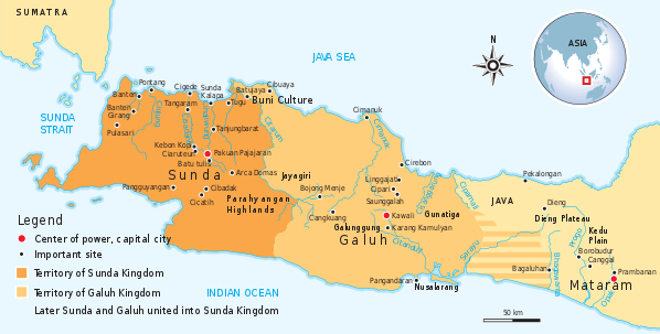
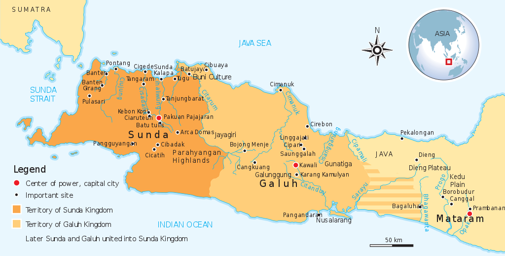
English: Historical map of the Sunda and Galuh Kingdoms of Java. |
||
| 日期 | |||
| 來源 | Own work by uploader, see #References for references used creating the map. | ||
| 作者 | Gunawan Kartapranata | ||
| 授權許可 (重用此檔案) |
我,本作品的著作權持有者,決定用以下授權條款發佈本作品: 此檔案採用創用CC 姓名標示-相同方式分享 3.0 未在地化版本授權條款。
您可以選擇您需要的授權條款。 |
||
| 其他版本 |
[]
|


|
This SVG file contains embedded text that can be translated into your language, using any capable SVG editor, text editor or the SVG Translate tool. For more information see: About translating SVG files. |
References
Resources used to create the map:
- Munoz, Paul Michel (2006年) 《 Early Kingdoms of the Indonesian Archipelago and the Malay Peninsula》、新加坡: Editions Didier Millet、pp. 203, 212 國際標準書號: 9814155675.
檔案歷史
點選日期/時間以檢視該時間的檔案版本。
| 日期/時間 | 縮圖 | 尺寸 | 使用者 | 備註 | |
|---|---|---|---|---|---|
| 目前 | 2012年2月8日 (三) 11:14 | | 598 × 303(225 KB) | Gunkarta | add Bojong Menje and Karang Kamulyan Site |
| 2009年11月8日 (日) 14:27 |  | 604 × 306(222 KB) | Gunkarta | ||
| 2009年11月6日 (五) 15:03 |  | 604 × 306(222 KB) | Gunkarta | Reverted to version as of 13:56, 6 November 2009 | |
| 2009年11月6日 (五) 14:00 |  | 604 × 306(222 KB) | Gunkarta | Identify separate entity of Sunda and Galuh kingdom, also remove Tarumanagara and Kalingga (Holing) because it belongs in deifferent era | |
| 2009年11月6日 (五) 13:56 |  | 604 × 306(222 KB) | Gunkarta | Identify the separate entity of Sunda and Galuh kingdom. Also removing Tarumanagara and Kalingga (Holing) because it is different era. | |
| 2009年11月5日 (四) 17:46 |  | 604 × 306(205 KB) | Gunkarta | {{Information |Description={{en|1=The historical map of Sunda Kingdom. Encompass the era from Tarumanagara, Galuh, and Sunda kingdom.}} |Source={{own}} |Author=Gunkarta Gunawan Kartapranata |Date=20091106 |Permission= |other_versions= }} |
檔案用途
下列頁面有用到此檔案:
全域檔案使用狀況
以下其他 wiki 使用了這個檔案:
- af.wikipedia.org 的使用狀況
- ar.wikipedia.org 的使用狀況
- az.wikipedia.org 的使用狀況
- de.wikipedia.org 的使用狀況
- en-two.iwiki.icu 的使用狀況
- eo.wikipedia.org 的使用狀況
- fi.wikipedia.org 的使用狀況
- fr.wikipedia.org 的使用狀況
- id.wikipedia.org 的使用狀況
- id.wikisource.org 的使用狀況
- it.wikipedia.org 的使用狀況
- ja-two.iwiki.icu 的使用狀況
- lt.wikipedia.org 的使用狀況
- ml.wikipedia.org 的使用狀況
- nl.wikipedia.org 的使用狀況
- no.wikipedia.org 的使用狀況
- ru.wikipedia.org 的使用狀況
- su.wikipedia.org 的使用狀況
- sv.wikipedia.org 的使用狀況
- uk.wikipedia.org 的使用狀況
- www.wikidata.org 的使用狀況