
File:Trans Alaska Pipeline Denali fault shift.jpg
預覽大小:800 × 600 像素。 其他解析度:320 × 240 像素 | 640 × 480 像素 | 1,024 × 768 像素 | 1,280 × 960 像素 | 2,560 × 1,920 像素。
原始檔案 (2,560 × 1,920 像素,檔案大小:570 KB,MIME 類型:image/jpeg)
摘要
| 描述 |
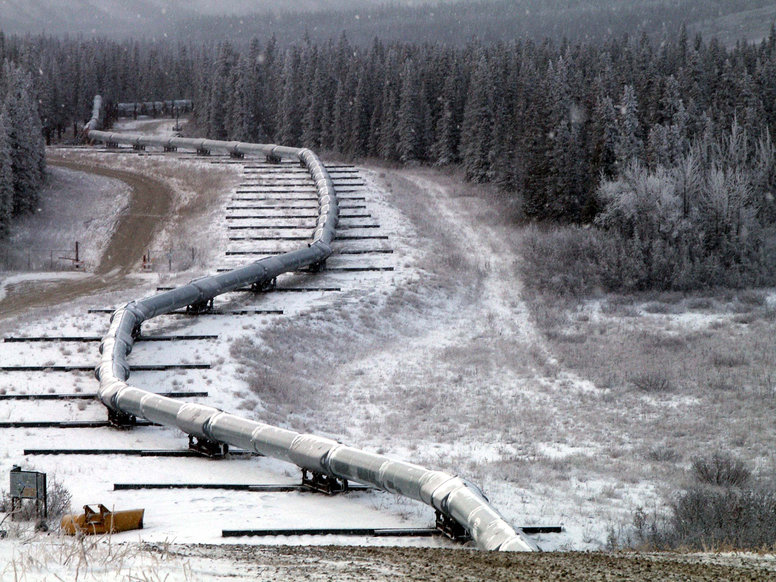
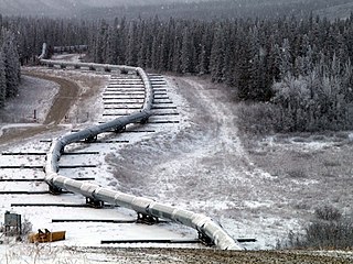
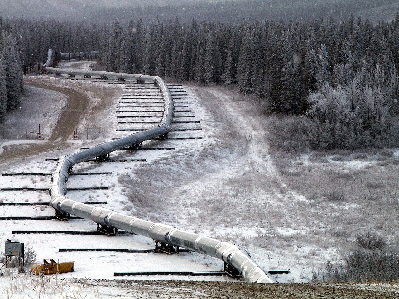
English: Trace of the Denali Fault after the 7.9 magnitude earthquake of 3 November 2002, Alaska, USA. View south along the Trans-Alaska Pipeline System in the zone where it was engineered to cross the fault (the pipeline rests on sliders rather than rigid pillar supports). The fault trace passes beneath the pipeline between the 2nd and 3rd slider supports at the far end of the zone. A large arc in the pipe can be seen in the pipe on the right, due to shortening of the zigzag-shaped pipeline trace within the fault zone. It was snowing when the photo was taken. |
| 日期 | |
| 來源 | Denali Fault Earthquake Photos 07 Nov 2002 (Direct link) |
| 作者 | U.S. Geological Survey employee |
| 拍攝地點 | | 位於此地的本圖片與其他圖片: OpenStreetMap |
|---|
授權條款
|
|
檔案歷史
點選日期/時間以檢視該時間的檔案版本。
| 日期/時間 | 縮圖 | 尺寸 | 使用者 | 備註 | |
|---|---|---|---|---|---|
| 目前 | 2007年8月4日 (六) 05:58 | | 2,560 × 1,920(570 KB) | Whhalbert | |
| 2007年8月4日 (六) 05:55 |  | 800 × 600(137 KB) | Whhalbert | == Summary == Alaska Denali Fault after November 3rd 7.9 magnitude earthquake: November 7, 2002. View south along the Trans-Alaska Pipeline System in the zone where it was engineered for the Denali fault. The fault trace passes beneath th |
檔案用途
下列2個頁面有用到此檔案:
全域檔案使用狀況
以下其他 wiki 使用了這個檔案:
- de.wikipedia.org 的使用狀況
- en-two.iwiki.icu 的使用狀況
- en.wikibooks.org 的使用狀況
- es.wikipedia.org 的使用狀況
- fa.wikipedia.org 的使用狀況
- fi.wikipedia.org 的使用狀況
- fr.wikipedia.org 的使用狀況
- ja-two.iwiki.icu 的使用狀況
- nl.wikipedia.org 的使用狀況
- pl.wikipedia.org 的使用狀況
- ru.wikipedia.org 的使用狀況
- th.wikipedia.org 的使用狀況
- tr.wikipedia.org 的使用狀況