
File:Muifa 2004-11-17 0455Z.jpg

預覽大小:466 × 599 像素。 其他解析度:187 × 240 像素 | 373 × 480 像素 | 597 × 768 像素 | 796 × 1,024 像素 | 1,593 × 2,048 像素 | 5,600 × 7,200 像素。
原始檔案 (5,600 × 7,200 像素,檔案大小:5.69 MB,MIME 類型:image/jpeg)
摘要
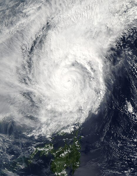
| 描述 | Typhoon Muifa spins off the eastern shore of Luzon in this Moderate Resolution Imaging Spectroradiometer (MODIS) image, acquired on November 17, 2004 by NASA’s Aqua satellite. The storm has already drenched the Philippine island of Catanduanes, causing floods and landslides, and is expected to turn west and cross over Luzon before the end of the week. Muifa reached typhoon status at about the time this image was taken at 4:55 UTC. By 12:00 UTC, the storm’s winds reached 139 kilometers per hour (86 mph) with gusts up to 167 kph (103 mph). | |||||
| 日期 | ||||||
| 來源 | http://visibleearth.nasa.gov/view_rec.php?id=6721 | |||||
| 作者 | Jacques Descloitres, MODIS Rapid Response Team, NASA/GSFC | |||||
| 授權許可 (重用此檔案) |
|

檔案歷史
點選日期/時間以檢視該時間的檔案版本。
| 日期/時間 | 縮圖 | 尺寸 | 使用者 | 備註 | |
|---|---|---|---|---|---|
| 目前 | 2006年9月6日 (三) 02:35 | | 5,600 × 7,200(5.69 MB) | Good kitty | == Summary == {{Information |Description=Typhoon Muifa spins off the eastern shore of Luzon in this Moderate Resolution Imaging Spectroradiometer (MODIS) image, acquired on November 17, 2004 by NASA’s Aqua satellite. The storm has already drenched the P |
檔案用途
下列頁面有用到此檔案:
全域檔案使用狀況
以下其他 wiki 使用了這個檔案:
- ja-two.iwiki.icu 的使用狀況
- th.wikipedia.org 的使用狀況
- vi.wikipedia.org 的使用狀況