
File:1593 Norden's map of Westminster surveyed and publ 1593 (1).jpg
此為最大尺寸。
1593_Norden's_map_of_Westminster_surveyed_and_publ_1593_(1).jpg (712 × 446 像素,檔案大小:193 KB,MIME 類型:image/jpeg)
.jpg?uselang=zh-hk)
.jpg?uselang=zh-hk)
.jpg?action=history&uselang=zh-hk)
.jpg)
摘要
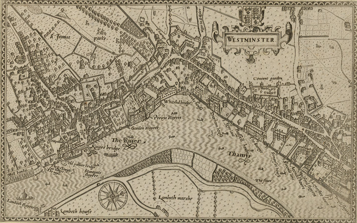
Norden's map of Westminster, surveyed and published 1593. From the Crace Collection at the British Library. The Strand, which is the main road on the right hand side of the map, was in its heyday as the favoured residence of the elite of the English aristocracy, and several of the major mansions located there are labelled on the map.
| 描述 | Norden's map of Westminster. | ||||
| 日期 | |||||
| 來源 | Crace Collection at the British Library. | ||||
| 作者 | Norden | ||||
| 授權許可 (重用此檔案) |
|
||||
檔案歷史
點選日期/時間以檢視該時間的檔案版本。
| 日期/時間 | 縮圖 | 尺寸 | 用戶 | 備註 | |
|---|---|---|---|---|---|
| 目前 | 2006年2月16日 (四) 19:10 | | 712 × 446(193 KB) | Merchbow~commonswiki | Norden's map of Westminster, surveyed and published 1593. From the Crace Collection at the British Library. Category:Maps of London category:City of Westminster |
檔案用途
下列頁面有用到此檔案:
全域檔案使用狀況
以下其他 wiki 使用了這個檔案:
- de.wikipedia.org 的使用狀況
- en-two.iwiki.icu 的使用狀況
- es.wikipedia.org 的使用狀況
- he.wikipedia.org 的使用狀況
- ja-two.iwiki.icu 的使用狀況
- nrm.wikipedia.org 的使用狀況
- sco.wikipedia.org 的使用狀況
.jpg)