
File:A15 PSR Fig 5-56 Planimetric map Station 1.jpg
此為最大尺寸。
A15_PSR_Fig_5-56_Planimetric_map_Station_1.jpg (442 × 258 像素,檔案大小:26 KB,MIME 類型:image/jpeg)
摘要
| 描述 |
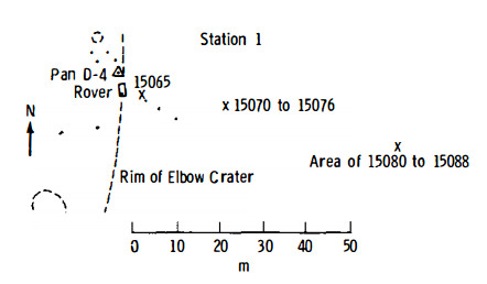
English: Figure 5-56 (edited slightly). Planimetric map of Apollo 15 Geology Station 1.
X indicates sample locations, 5-digit numbers are LRL sample numbers, rectangle is lunar rover (dot indicates TV camera), black spots are large rocks, dashed lines are crater rims or other topographic features, and triangles are panorama stations. |
| 日期 | |
| 來源 | Apollo 15 Preliminary Science Report, 1972, NASA SP-289, Scientific and Technical Information Office, National Aeronautics and Space Administration, Washington, D.C. [1] |
| 作者 | NASA |
授權條款
| 本作品由NASA創作,屬於公有領域。根據NASA的版權政策:“NASA的創作除非另有聲明否則不受版權保護。”(參見:Template:PD-USGov/zh,NASA版權政策或JPL圖像使用政策) | ||
 |
警告:
|
檔案歷史
點選日期/時間以檢視該時間的檔案版本。
| 日期/時間 | 縮圖 | 尺寸 | 用戶 | 備註 | |
|---|---|---|---|---|---|
| 目前 | 2016年8月29日 (一) 01:45 | | 442 × 258(26 KB) | Jstuby | User created page with UploadWizard |
檔案用途
下列2個頁面有用到此檔案:
全域檔案使用狀況
以下其他 wiki 使用了這個檔案:
- en-two.iwiki.icu 的使用狀況
- es.wikipedia.org 的使用狀況