
File:Adams onis map.png
預覽大小:733 × 599 像素。 其他解析度:294 × 240 像素 | 587 × 480 像素。
原始檔案 (800 × 654 像素,檔案大小:226 KB,MIME 類型:image/png)

|
File:Adams-Onís treaty map-en.svg是本檔案的向量版本。 如果品質不低,就應該優先使用該檔案,而非PNG檔案。
File:Adams onis map.png → File:Adams-Onís treaty map-en.svg
更多資訊請參閱Help:SVG/zh。 |
 |
摘要
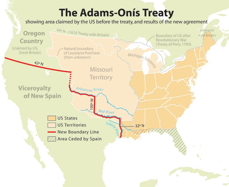
English: Map showing the results of the Adams-Onís Treaty of 1819.
Please state the map from which this was traced, or the other cartographic sources that provided the information allowing you to create the boundaries show.[citation needed]
en:User:Citynoise is the creator at stated at source: I, Citynoise, am the creator of this map and hereby release it per the ShareAlike Attribution license. See www.radicalcartography.net for more.
授權條款
此檔案採用創用CC 姓名標示-相同方式分享 2.5 通用版授權條款。
- 您可以自由:
- 分享 – 複製、發佈和傳播本作品
- 重新修改 – 創作演繹作品
- 惟需遵照下列條件:
- 姓名標示 – 您必須指名出正確的製作者,和提供授權條款的連結,以及表示是否有對內容上做出變更。您可以用任何合理的方式來行動,但不得以任何方式表明授權條款是對您許可或是由您所使用。
- 相同方式分享 – 如果您利用本素材進行再混合、轉換或創作,您必須基於如同原先的相同或兼容的條款,來分布您的貢獻成品。
檔案歷史
點選日期/時間以檢視該時間的檔案版本。
| 日期/時間 | 縮圖 | 尺寸 | 用戶 | 備註 | |
|---|---|---|---|---|---|
| 目前 | 2012年7月18日 (三) 18:56 | | 800 × 654(226 KB) | Kmusser | rm Russian claim to Oregon (was dropped by the timeframe of this map - see Adams-Onis talk page) |
| 2006年7月10日 (一) 19:42 |  | 800 × 654(227 KB) | JMPerez~commonswiki | == Summary == Map showing the results of the Adams-Onís Treaty of 1819. I, Citynoise, am the creator of this map and hereby release it per the ShareAlike Attribution license. See www.radicalcartography.net for more. From English Wikipedia. == Licensin |
檔案用途
下列頁面有用到此檔案:
全域檔案使用狀況
以下其他 wiki 使用了這個檔案:
- ar.wikipedia.org 的使用狀況
- ca.wikipedia.org 的使用狀況
- cs.wikipedia.org 的使用狀況
- da.wikipedia.org 的使用狀況
- de.wikipedia.org 的使用狀況
- en-two.iwiki.icu 的使用狀況
- John Quincy Adams
- James Monroe
- Adams–Onís Treaty
- Moses Austin
- Spanish Canadians
- Spanish Texas
- Presidency of James Monroe
- User:Esemono/British
- Territorial evolution of the Caribbean
- List of territorial claims and designations in Colorado
- Early history of the Arkansas Valley in Colorado
- History of U.S. foreign policy, 1801–1829
- Long's Expedition of 1820
- User:Falcaorib/Canada, United States and Mexico
- eu.wikipedia.org 的使用狀況
- fa.wikipedia.org 的使用狀況
- fi.wikipedia.org 的使用狀況
- he.wikipedia.org 的使用狀況
- hu.wikipedia.org 的使用狀況
- id.wikipedia.org 的使用狀況
- it.wikipedia.org 的使用狀況
- ja-two.iwiki.icu 的使用狀況
- ko.wikipedia.org 的使用狀況
- nl.wikipedia.org 的使用狀況
- no.wikipedia.org 的使用狀況
- pl.wikipedia.org 的使用狀況
- pnb.wikipedia.org 的使用狀況
- pt.wikipedia.org 的使用狀況
- ro.wikipedia.org 的使用狀況
- ru.wikipedia.org 的使用狀況
- simple.wikipedia.org 的使用狀況
- sr.wikipedia.org 的使用狀況
- sv.wikipedia.org 的使用狀況
- th.wikipedia.org 的使用狀況
- uk.wikipedia.org 的使用狀況
- ur.wikipedia.org 的使用狀況
檢視此檔案的更多全域使用狀況。