
File:Apollo 16 landing site AS16-M-0440.jpg
此為最大尺寸。
Apollo_16_landing_site_AS16-M-0440.jpg (405 × 299 像素,檔案大小:110 KB,MIME 類型:image/jpeg)
摘要
| 描述 |
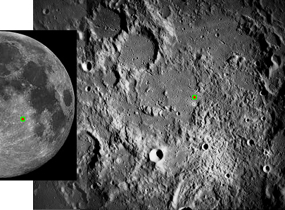
English: Diagram of Apollo 16 landing site, Descartes Highlands, on the moon. The landing site is marked by a yellow and red dot on each image. |
| 日期 | created 2014, original 1972 |
| 來源 |
Apollo 16 Mapping camera image rotated and cropped in Gimp to show the landing site. This image is in the public domain because is a work of the U.S. Government (NASA). The image at left is cropped from file:FullMoon2010.jpg, Wikimedia Commons. Mapping Camera Image Catalog, Apollo 16, AS16-M-0440 |
| 作者 |
James Stuby based on NASA image |
本圖像或影音收錄於美國國家航空暨太空總署 (NASA)某部門,其照片編號為: AS16-M-0440 此標籤不表示文件的著作權狀態。任何文件在附有此標籤的同時還需要一個有效的著作權標籤。請參閱許可協議說明頁面以了解更多資訊。 其他語言:
|
授權條款
| 此檔案在創用CC CC0 1.0 通用公有領域貢獻宣告之下分發。 | |
| 在此宣告之下分發本作品者,已依據各國著作權法,在全世界放棄其對本作品所擁有的著作權及所有相關相似的法律權利,從而將本作品貢獻至公有領域。您可以複製、修改、分發和演示該作品,用於任何商業用途,所有這些都不需要請求授權。
|
原始上傳日誌
The original description page was here. All following user names refer to en.wikipedia.
- 2014-01-17 04:53 Jstuby 405×299× (112322 bytes) {{Information |Description = Diagram of [[Apollo 16]] landing site, Descartes Highlands, on the moon. The landing site is marked by a yellow and red dot on each image. |Source = [[Apollo 16]] Mapping camera image rotated and cropped in Gimp to show th...
檔案歷史
點選日期/時間以檢視該時間的檔案版本。
| 日期/時間 | 縮圖 | 尺寸 | 用戶 | 備註 | |
|---|---|---|---|---|---|
| 目前 | 2014年6月30日 (一) 18:32 | | 405 × 299(110 KB) | Arthunter | Transferred from en.wikipedia |
檔案用途
下列頁面有用到此檔案:
全域檔案使用狀況
以下其他 wiki 使用了這個檔案:
- bn.wikipedia.org 的使用狀況
- en-two.iwiki.icu 的使用狀況
- es.wikipedia.org 的使用狀況
- it.wikipedia.org 的使用狀況
- ja-two.iwiki.icu 的使用狀況
- nl.wikipedia.org 的使用狀況
- pt.wikipedia.org 的使用狀況