
File:Arabische Eroberung 2.jpg

預覽大小:800 × 506 像素。 其他解析度:320 × 202 像素 | 640 × 404 像素 | 1,024 × 647 像素 | 1,280 × 809 像素 | 2,560 × 1,618 像素 | 4,496 × 2,841 像素。
原始檔案 (4,496 × 2,841 像素,檔案大小:3.36 MB,MIME 類型:image/jpeg)
摘要
| 描述 |
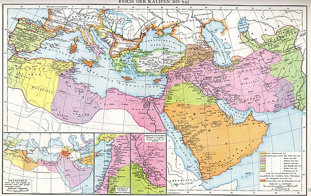
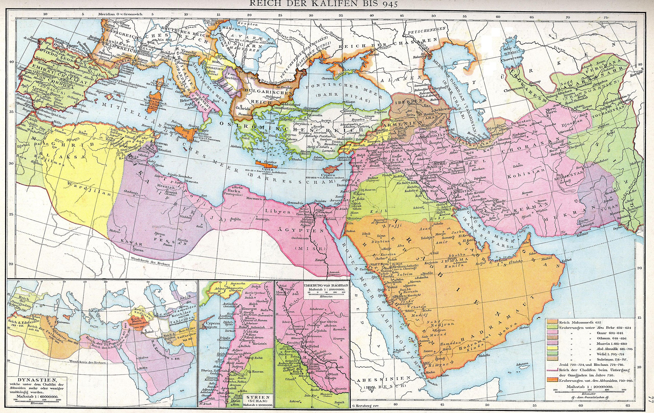
Deutsch: Das Reich der Kalifen bis 945. Karte aus dem Historischen Handatlas von Gustav Droysen, 1886
English: The empire of the Caliphs to 945. Map of the Historical Atlas of Gustav Droysen, 1886 |
| 日期 | |
| 來源 | Gustav Droysens Allgemeiner historischer Handatlas in 96 Karten mit erläuterndem Text Bielefeld [u.a.]: Velhagen & Klasing 1886, S. 77. |
| 作者 | Johann Gustav Droysen (6 July 1808 – 19 June 1884) |
| 其他版本 |
Derivative works of this file: |
.jpg)
授權條款
|
本作品在其來源國以及其他版權期限是作者逝世後100年或以下的國家與地區屬於公有領域。 | |
| 此作品無已知的著作權限制,亦不受所有相關和鄰接的權利限制。 | |
檔案歷史
點選日期/時間以檢視該時間的檔案版本。
| 日期/時間 | 縮圖 | 尺寸 | 用戶 | 備註 | |
|---|---|---|---|---|---|
| 目前 | 2012年8月10日 (五) 13:23 | | 4,496 × 2,841(3.36 MB) | Cplakidas | larger & better quality |
| 2007年2月24日 (六) 00:51 |  | 2,187 × 1,389(754 KB) | Nikephoros | {{Information |Description=Karte des Kalifates vom Tode Mohammeds bis 945 |Source=Professor G. Droysens Allgemeiner Historischer Handatlas |Date=1886 |Author=G. Droysen |Permission=not necessary |other_versions= }} |
檔案用途
下列3個頁面有用到此檔案:
全域檔案使用狀況
以下其他 wiki 使用了這個檔案:
- ar.wikipedia.org 的使用狀況
- az.wikipedia.org 的使用狀況
- de.wikipedia.org 的使用狀況
- de.wikiversity.org 的使用狀況
- el.wikipedia.org 的使用狀況
- en-two.iwiki.icu 的使用狀況
- Mu'awiya I
- Al-Mu'tasim
- Al-Mada'in
- Abbasid invasion of Asia Minor (806)
- Fourth Fitna
- User:Al Ameer son/Abd al-Malik
- User:Al Ameer son/Al-Walid I
- User:Al Ameer son/Sulayman
- User:Al Ameer son/Umayyad Caliphate
- Wikipedia:Graphics Lab/Map workshop/Archive/Apr 2023
- User:Falcaorib/Medieval Empires (800-1000 AD)
- es.wikipedia.org 的使用狀況
- fa.wikibooks.org 的使用狀況
- fr.wikipedia.org 的使用狀況
- id.wikipedia.org 的使用狀況
- it.wikipedia.org 的使用狀況
- ja-two.iwiki.icu 的使用狀況
- ka.wikipedia.org 的使用狀況
- sl.wikipedia.org 的使用狀況
- sq.wikipedia.org 的使用狀況
- sr.wikipedia.org 的使用狀況
- tr.wikipedia.org 的使用狀況
- ur.wikipedia.org 的使用狀況
- uz.wikipedia.org 的使用狀況