
File:KYphysiography.jpg

預覽大小:800 × 353 像素。 其他解析度:320 × 141 像素 | 824 × 364 像素。
原始檔案 (824 × 364 像素,檔案大小:159 KB,MIME 類型:image/jpeg)

|
本圖片是以PNG、GIF或JPEG格式上傳。然而,其中包含的資料或訊息,應該重新建立成可縮放向量圖形(SVG)檔案,以更有效率或更準確的方式儲存。如有可能,請上傳本圖片的SVG格式版本。在上傳之後,請修改維基各姊妹計畫中所有使用舊版圖片的條目(列在圖像連結章節中),替換為新版圖片,並在舊圖片的描述頁中加入{{Vector version available|新圖片名稱.svg}}模板,同時移除本模板。
|


摘要
| 描述 |
English: I created this image using Wikipedia's map of Kentucky counties.
|
| 日期 | 2007年五月1日 (原始上傳日期) |
| 來源 | Transferred from en.wikipedia to Commons by byankno1. |
| 作者 | 英文維基百科的Lamontacranston |
授權條款
| 此作品已由其作者,英文維基百科的Lamontacranston,釋出至公有領域。此授權條款在全世界均適用。 這可能在某些國家不合法,如果是的話: Lamontacranston授予任何人有權利使用此作品於任何用途,除受法律約束外,不受任何限制。 |
原始上傳日誌
The original description page was here. All following user names refer to en.wikipedia.
- 2007-05-01 00:01 Lamontacranston 824×364× (162592 bytes) Bigger fonts. I created this image.
- 2007-04-30 23:54 Lamontacranston 824×364× (154693 bytes) Added text, improved edges, slightly lightened colors. I created the original.
- 2006-09-09 19:16 Lamontacranston 824×364× (55286 bytes) I created this image using Wikipedia's map of Kentucky counties.
檔案歷史
點選日期/時間以檢視該時間的檔案版本。
| 日期/時間 | 縮圖 | 尺寸 | 用戶 | 備註 | |
|---|---|---|---|---|---|
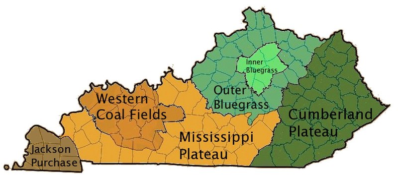
| 目前 | 2008年11月18日 (二) 16:36 | | 824 × 364(159 KB) | EpcotMagic | {{Information |Description={{en|I created this image using Wikipedia's map of Kentucky counties. *Dark green - Eastern Kentucky Coal fields (Cumberland Plateau) *Green - Outer Bluegrass *Light Green - Inner Bluegrass *Light Brown - Mississippi (Pennyroyal |
檔案用途
下列頁面有用到此檔案:
全域檔案使用狀況
以下其他 wiki 使用了這個檔案:
- ar.wikipedia.org 的使用狀況
- de.wikipedia.org 的使用狀況
- el.wikipedia.org 的使用狀況
- en-two.iwiki.icu 的使用狀況
- es.wikipedia.org 的使用狀況
- fi.wikipedia.org 的使用狀況
- he.wikipedia.org 的使用狀況
- ia.wikipedia.org 的使用狀況
- id.wikipedia.org 的使用狀況
- it.wikipedia.org 的使用狀況
- ja-two.iwiki.icu 的使用狀況
- no.wikipedia.org 的使用狀況
- pt.wikipedia.org 的使用狀況
- sh.wikipedia.org 的使用狀況
- simple.wikipedia.org 的使用狀況
- sv.wikipedia.org 的使用狀況
- vi.wikipedia.org 的使用狀況