
File:Map of Operation Eagle Pull evacuation sites.jpg
此為最大尺寸。
Map_of_Operation_Eagle_Pull_evacuation_sites.jpg (600 × 552 像素,檔案大小:95 KB,MIME 類型:image/jpeg)
摘要
| 描述 |
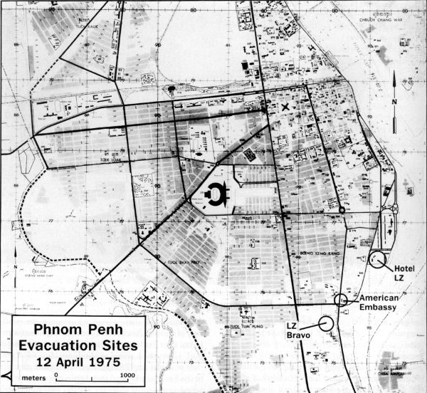
English: Map of possible helicopter landing zones for use in Operation Eagle Pull |
| 日期 | |
| 來源 | http://www.history.navy.mil/index.html |
| 作者 | US Navy |
授權條款
 | ||
| 此作品無已知的著作權限制,亦不受所有相關和鄰接的權利限制。 | ||
檔案歷史
點選日期/時間以檢視該時間的檔案版本。
| 日期/時間 | 縮圖 | 尺寸 | 用戶 | 備註 | |
|---|---|---|---|---|---|
| 目前 | 2010年2月7日 (日) 09:11 | | 600 × 552(95 KB) | Mztourist | {{Information |Description={{en|1=Map of possible helicopter landing zones for use in Operation Eagle Pull}} |Source=http://www.history.navy.mil/index.html |Author=US Navy |Date=1975-04 |Permission= |other_versions= }} Category:Operation Eagle Pull [ |
檔案用途
下列頁面有用到此檔案:
全域檔案使用狀況
以下其他 wiki 使用了這個檔案:
- br.wikipedia.org 的使用狀況
- de.wikipedia.org 的使用狀況
- en-two.iwiki.icu 的使用狀況
- ru.wikipedia.org 的使用狀況
- vi.wikipedia.org 的使用狀況