
File:Map of the route of Edward III's chevauchée of 1346.svg

此 SVG 檔案的 PNG 預覽的大小:643 × 600 像素。 其他解析度:257 × 240 像素 | 515 × 480 像素 | 823 × 768 像素 | 1,098 × 1,024 像素 | 2,195 × 2,048 像素 | 1,059 × 988 像素。
原始檔案 (SVG 檔案,表面大小:1,059 × 988 像素,檔案大小:450 KB)
摘要
| 描述 |
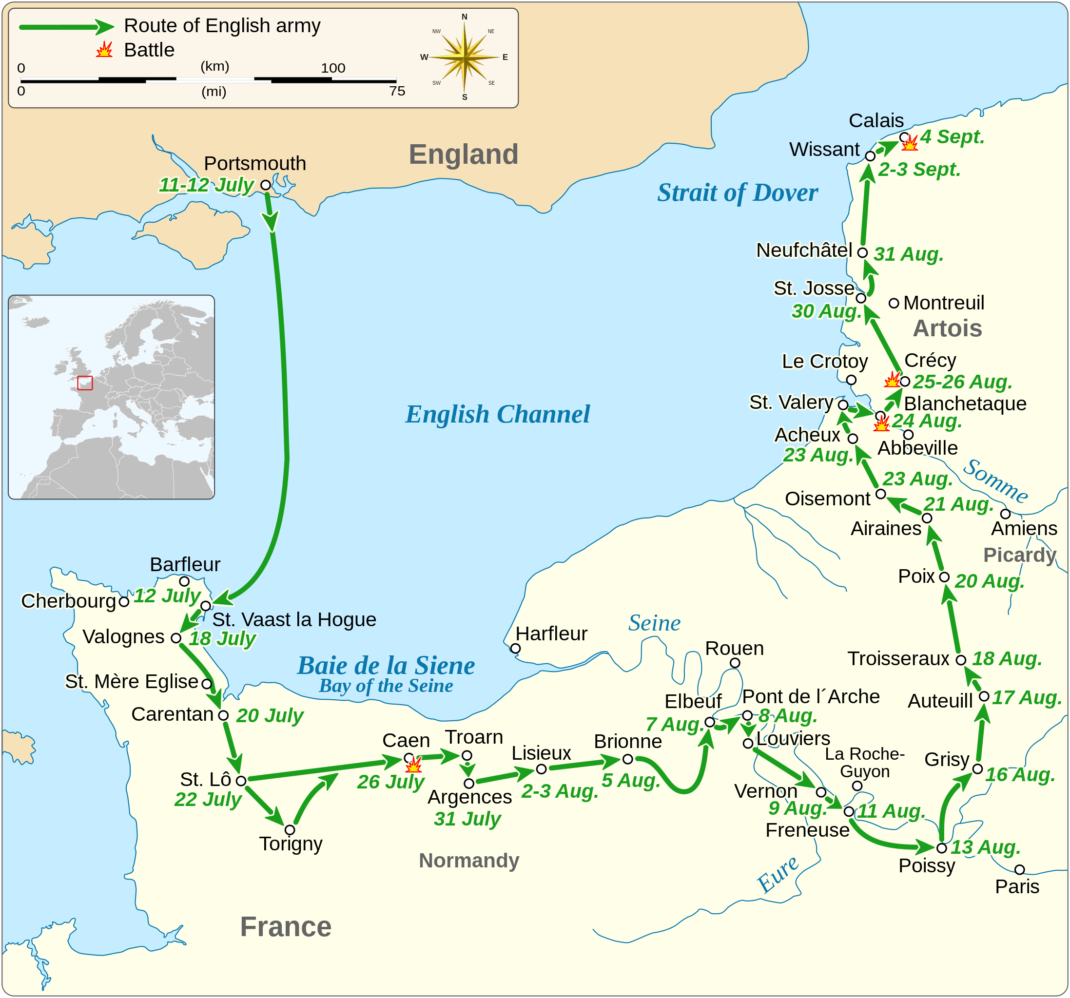
English: Map of the route of Edward III's chevauchée of 1346, part of the Hundred Years' War. This map shows the English army movements during the campaign and the most important battles.
|
|||
| 日期 | ||||
| 來源 |
自己的作品 Derived from; Information from:
|
|||
| 作者 | Goran tek-en | |||
| 授權許可 (重用此檔案) |
此檔案採用共享創意 姓名標示-相同方式分享 4.0 國際授權條款。 姓名標示: Goran tek-en
|
|||
| SVG開發 |


| 目標地點 | | 位於此地的本圖片與其他圖片: OpenStreetMap |
|---|


檔案歷史
點選日期/時間以檢視該時間的檔案版本。
| 日期/時間 | 縮圖 | 尺寸 | 用戶 | 備註 | |
|---|---|---|---|---|---|
| 目前 | 2022年2月3日 (四) 00:14 | | 1,059 × 988(450 KB) | Iso10970 | Reverted to version as of 13:17, 9 November 2021 (UTC) |
| 2022年2月3日 (四) 00:13 |  | 1,059 × 988(614 KB) | Iso10970 | File uploaded using svgtranslate tool (https://svgtranslate.toolforge.org/). Added translation for ja. | |
| 2021年11月9日 (二) 13:17 |  | 1,059 × 988(450 KB) | Goran tek-en | Changed view box, font size, added location map | |
| 2019年4月14日 (日) 13:06 |  | 1,059 × 988(191 KB) | Goran tek-en | Spelling | |
| 2019年3月10日 (日) 17:53 |  | 1,059 × 988(115 KB) | JoKalliauer | phab:T36947 bad character aligment on same sizes | |
| 2019年3月6日 (三) 14:08 |  | 1,059 × 988(191 KB) | Goran tek-en | {{Information |description ={{en|1=Map of the route of Edward III's chevauchée of 1346, part of the Hundred Years' War. This map shows the English army movements during the campaign and the most important battles.}} |date =20190306 |source ={{Own}}<br> Derived from; * [https://www.openstreetmap.org/#map=8/49.919/1.371 OSM] Information from: * [https://www.themaparchive.com/the-crecy-campaign-12-july-to-4-september-1346.html themaparchive.com] * {{U|Newm30}} |author... |
檔案用途
下列2個頁面有用到此檔案:
全域檔案使用狀況
以下其他 wiki 使用了這個檔案:
- cs.wikipedia.org 的使用狀況
- en-two.iwiki.icu 的使用狀況
- es.wikipedia.org 的使用狀況
- fi.wikipedia.org 的使用狀況
- fr.wikipedia.org 的使用狀況
- hu.wikipedia.org 的使用狀況
- ja-two.iwiki.icu 的使用狀況
- nl.wikipedia.org 的使用狀況
- pt.wikipedia.org 的使用狀況
- ru.wikipedia.org 的使用狀況
- sh.wikipedia.org 的使用狀況
- tr.wikipedia.org 的使用狀況