
File:Mapa del archipiélago Chinijo.svg

此 SVG 檔案的 PNG 預覽的大小:800 × 566 像素。 其他解析度:320 × 226 像素 | 640 × 453 像素 | 1,024 × 724 像素 | 1,280 × 905 像素 | 2,560 × 1,810 像素 | 1,052 × 744 像素。
原始檔案 (SVG 檔案,表面大小:1,052 × 744 像素,檔案大小:5.48 MB)
摘要
| 描述 |
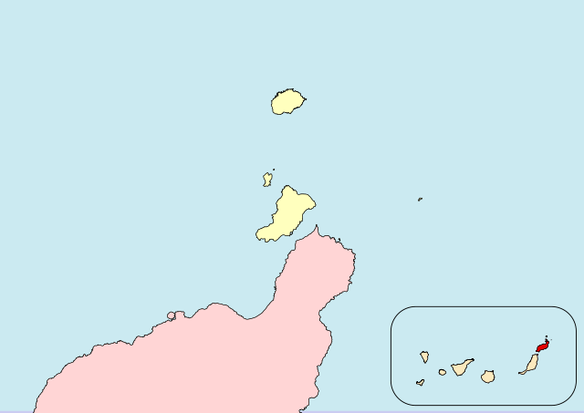
Español: Archipiélago Chinijo (Lanzarote, Canarias, España)
English:Chinijo-Archipel (Lanzarote, Canary Islands, Spain) |
| 日期 |
|
| 來源 |
自己的作品 |
| 作者 |
Iván Hernández Cazorla |
|date=2016-05-13 |source=自己的作品 a partir de:
- Instituto Geográfico Nacional. BCN 200 (Base de datos en línea). Centro de Descargas del Centro Nacional de Información Geográfica. Retrieved on 2016-05-13.
- Gobierno de Canarias (2006-09-21). BOC - 2006/185. Jueves 21 de Septiembre de 2006 - 1278 (Institucional). Boletín Oficial de Canarias. Retrieved on 2016-05-18.
|author=Iván Hernández Cazorla
|other fields=SVG開發
}}
| 拍攝地點 | | 位於此地的本圖片與其他圖片: OpenStreetMap |
|---|
授權條款
I, Iván Hernández Cazorla, have published this work under the terms of the license CC BY-SA 4.0, which allow you use and share this work, and create derivative works; under the condition of give me credit of the work using the same license. For that, please, add legibly:
Use this work in compliance with the terms of the license! If you use this work outside of the Wikimedia Projects, you can contact with me sending an email to 我,本作品的著作權持有者,決定用以下授權條款發佈本作品: 此檔案採用共享創意 姓名標示-相同方式分享 4.0 國際授權條款。
|
檔案歷史
點選日期/時間以檢視該時間的檔案版本。
| 日期/時間 | 縮圖 | 尺寸 | 用戶 | 備註 | |
|---|---|---|---|---|---|
| 目前 | 2016年5月18日 (三) 18:27 | | 1,052 × 744(5.48 MB) | Ivanhercaz | Revierto a la versión del 13 de mayo de 2016 a las 16:50 16:50, 13 May 2016 (UTC) para que el contenido del mapa esté acorde a su función. Aparte, subiré otro mapa con la delimitación del Parque Natural. |
| 2016年5月18日 (三) 01:00 |  | 1,052 × 744(4.23 MB) | Ivanhercaz | Eliminación de etiqueta <flowRoot> en el cuadro de la comunidad autónoma: solución al recuadro negro en la esquina superior-izquierda. | |
| 2016年5月18日 (三) 00:42 |  | 1,052 × 744(4.24 MB) | Ivanhercaz | Añado una leyenda mínima y necesaria para entender la zona resaltada del mapa. | |
| 2016年5月18日 (三) 00:05 |  | 1,052 × 744(4.41 MB) | Ivanhercaz | Establezco los límites correctos del archipiélago Chinijo según el BOC 2006/185 1278. | |
| 2016年5月13日 (五) 16:50 |  | 1,052 × 744(5.48 MB) | Ivanhercaz | Un trazo más fino en el cuadro de localización de Canarias. | |
| 2016年5月13日 (五) 14:48 |  | 1,052 × 744(5.46 MB) | Ivanhercaz | User created page with UploadWizard |
檔案用途
下列頁面有用到此檔案:
全域檔案使用狀況
以下其他 wiki 使用了這個檔案:
- an.wikipedia.org 的使用狀況
- es.wikipedia.org 的使用狀況
- nl.wikivoyage.org 的使用狀況
- ru.wikipedia.org 的使用狀況