
File:MarsCuriosityRover-TraverseMap-Sol-0746-20140911.jpg

預覽大小:776 × 600 像素。 其他解析度:311 × 240 像素 | 621 × 480 像素 | 994 × 768 像素 | 1,280 × 989 像素 | 2,560 × 1,978 像素 | 3,300 × 2,550 像素。
原始檔案 (3,300 × 2,550 像素,檔案大小:1.34 MB,MIME 類型:image/jpeg)
摘要
| 描述 |
English: 09.11.2014
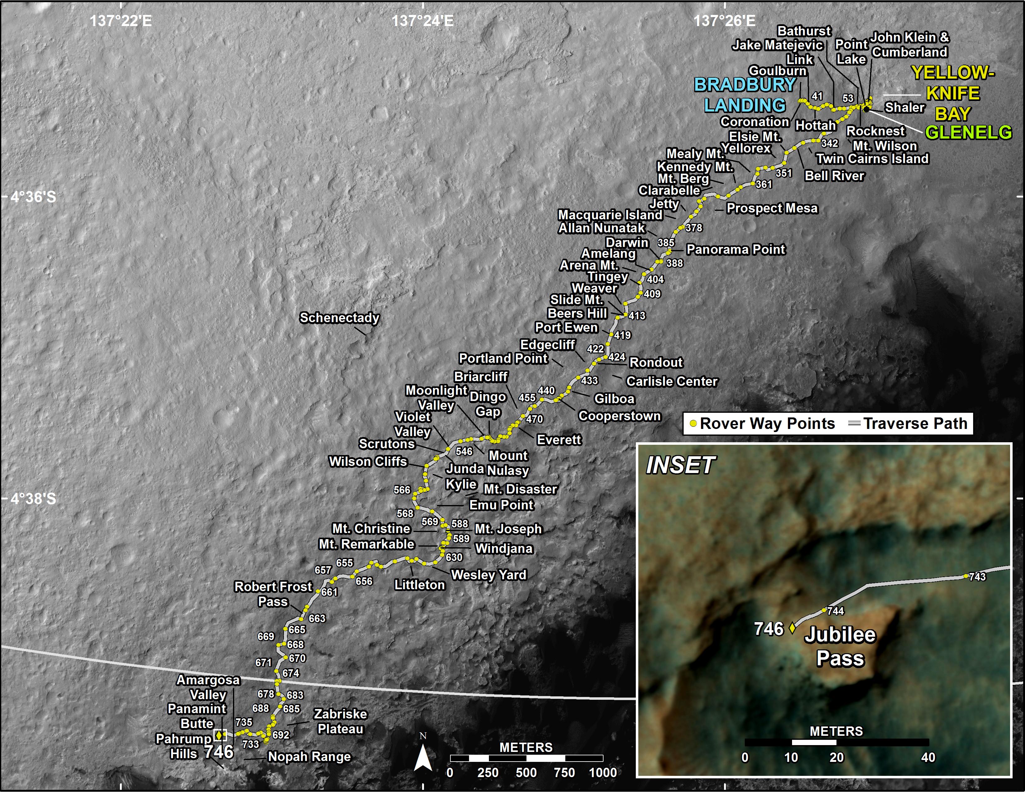
Curiosity's Traverse Map Through Sol 746 - Arrival at the slopes of Mount Sharp in Gale Crater on the planet Mars. http://mars.jpl.nasa.gov/msl/multimedia/images/?ImageID=6587 This map shows the route driven by NASA's Mars rover Curiosity through the 746 Martian day, or sol, of the rover's mission on Mars (September 11, 2014). Numbering of the dots along the line indicate the sol number of each drive. North is up. The scale bar is 1 kilometer (~0.62 mile). From Sol 744 to Sol 746, Curiosity had driven a straight line distance of about 26.19 feet (7.983 meters). The base image from the map is from the High Resolution Imaging Science Experiment Camera (HiRISE) in NASA's Mars Reconnaissance Orbiter. |
| 日期 | |
| 來源 | http://mars.jpl.nasa.gov/msl/images/MSL_TraverseMap_Sol0746-full.jpg |
| 作者 | NASA/JPL-Caltech/Univ. of Arizona |
授權條款
| 本作品由NASA創作,屬於公有領域。根據NASA的版權政策:“NASA的創作除非另有聲明否則不受版權保護。”(參見:Template:PD-USGov/zh,NASA版權政策或JPL圖像使用政策) | ||
 |
警告:
|
檔案歷史
點選日期/時間以檢視該時間的檔案版本。
| 日期/時間 | 縮圖 | 尺寸 | 用戶 | 備註 | |
|---|---|---|---|---|---|
| 目前 | 2014年9月19日 (五) 20:01 | | 3,300 × 2,550(1.34 MB) | Drbogdan | User created page with UploadWizard |
檔案用途
下列頁面有用到此檔案:
全域檔案使用狀況
以下其他 wiki 使用了這個檔案:
- en-two.iwiki.icu 的使用狀況
- tr.wikipedia.org 的使用狀況
- uk.wikipedia.org 的使用狀況