
File:Miyamoto Crater.JPG
此為最大尺寸。
Miyamoto_Crater.JPG (524 × 464 像素,檔案大小:34 KB,MIME 類型:image/jpeg)
摘要
| 描述 |
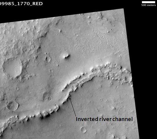
English: Miyamoto Crater, as seen by hirise. The location is 3 degrees south latitude and 352.1 degrees east longitude. Image was taken by the Mars Reconnaissance Orbiter's HiRISE. The HiRISE camera was built by Ball Aerospace and Technology orporation and is operated by the University of Arizona. Image courtesy NASA/JPL/University of Arizona. |
|||||
| 日期 | ||||||
| 來源 | http://hirise.lpl.arizona.edu/PSP_009985_1770. Transferred from en.wikipedia to Commons by Magnus Manske using CommonsHelper. | |||||
| 作者 | NASA/JPL/University of Arizona. Jim Secosky (Jimmarsmars) modified NASA image. | |||||
| 授權許可 (重用此檔案) |
|

| 火星上的位置 | 位於此地的本圖片與其他圖片: Google地图 |
|---|
原始上傳日誌
The original description page was here. All following user names refer to en.wikipedia.
- 2009-02-25 17:01 Jimmarsmars 524×464× (34352 bytes) {{Information |Description=Miyamoto Crater, as seen by hirise. The location is 3 degrees south latitude and 352.1 degrees east longitude. |Source=http://hirise.lpl.arizona.edu/PSP_009985_1770 |Date=February 25, 2009 |Author=Jim Secosky modified NASA ima
檔案歷史
點選日期/時間以檢視該時間的檔案版本。
| 日期/時間 | 縮圖 | 尺寸 | 用戶 | 備註 | |
|---|---|---|---|---|---|
| 目前 | 2011年2月20日 (日) 12:33 | | 524 × 464(34 KB) | File Upload Bot (Magnus Manske) | {{BotMoveToCommons|en.wikipedia|year={{subst:CURRENTYEAR}}|month={{subst:CURRENTMONTHNAME}}|day={{subst:CURRENTDAY}}}} {{Information |Description={{en|Miyamoto Crater, as seen by hirise. The location is 3 degrees south latitude and 352.1 degrees east lo |
檔案用途
全域檔案使用狀況
以下其他 wiki 使用了這個檔案:
- el.wikipedia.org 的使用狀況
- en-two.iwiki.icu 的使用狀況
- fr.wikipedia.org 的使用狀況
- mk.wikipedia.org 的使用狀況
- pl.wikipedia.org 的使用狀況
- pnb.wikipedia.org 的使用狀況
- ru.wikipedia.org 的使用狀況
- ur.wikipedia.org 的使用狀況