
File:PIA22329-Mars-DustStorm-20180606.jpg

原始檔案 (5,760 × 2,880 像素,檔案大小:2.12 MB,MIME 類型:image/jpeg)
摘要
| 描述 |
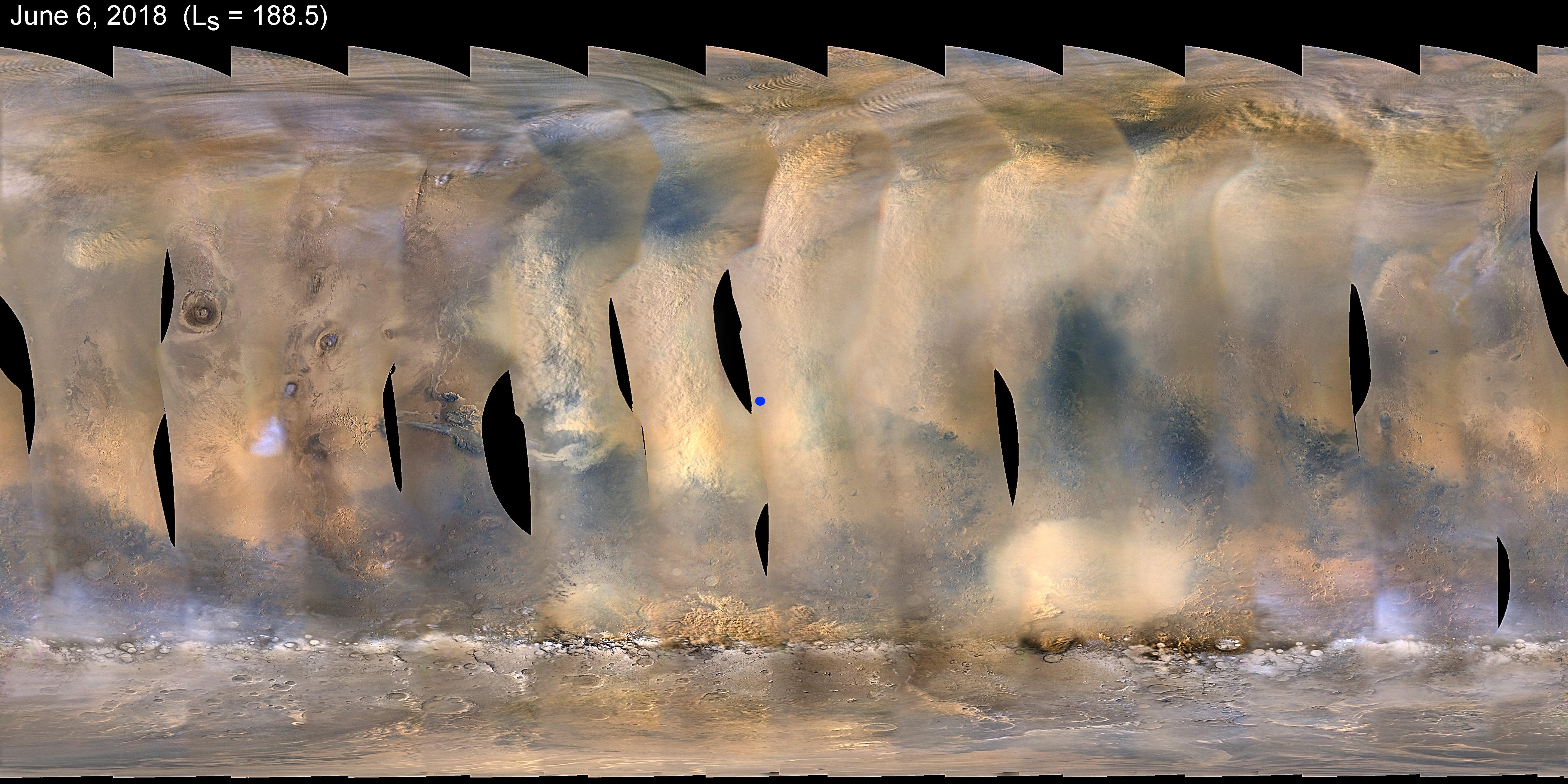
English: PIA22329: Dust Storm Covers Opportunity
This global map of Mars shows a growing dust storm as of June 6, 2018. The map was produced by the Mars Color Imager (MARCI) camera on NASA's Mars Reconnaissance Orbiter spacecraft. The blue dot shows the approximate location of Opportunity. The storm was first detected on June 1. The MARCI camera has been used to monitor the storm ever since. Full dust storms like this one are not surprising, but are infrequent. They can crop up suddenly but last weeks, even months. During southern summer, sunlight warms dust particles, lifting them higher into the atmosphere and creating more wind. That wind kicks up yet more dust, creating a feedback loop that NASA scientists still seek to understand. Malin Space Science Systems, San Diego, provided and operates MARCI. NASA's Jet Propulsion Laboratory, a division of Caltech in Pasadena, California, manages the Mars Reconnaissance Orbiter for NASA's Science Mission Directorate, Washington. Lockheed Martin Space Systems, Denver, built the spacecraft. |
| 日期 | 攝於2018年六月6日 |
| 來源 | https://photojournal.jpl.nasa.gov/catalog/PIA22329 (image link) |
| 作者 | NASA/JPL-Caltech/MSSS |
| 其他版本 |
|

授權條款
| 本作品由NASA創作,屬於公有領域。根據NASA的版權政策:“NASA的創作除非另有聲明否則不受版權保護。”(參見:Template:PD-USGov/zh,NASA版權政策或JPL圖像使用政策) | ||
 |
警告:
|
檔案歷史
點選日期/時間以檢視該時間的檔案版本。
| 日期/時間 | 縮圖 | 尺寸 | 用戶 | 備註 | |
|---|---|---|---|---|---|
| 目前 | 2018年6月12日 (二) 18:31 | | 5,760 × 2,880(2.12 MB) | Drbogdan | User created page with UploadWizard |
檔案用途
下列頁面有用到此檔案:
全域檔案使用狀況
以下其他 wiki 使用了這個檔案:
- ar.wikipedia.org 的使用狀況
- de.wikipedia.org 的使用狀況
- en-two.iwiki.icu 的使用狀況
- es.wikipedia.org 的使用狀況
- eu.wikipedia.org 的使用狀況
- it.wikipedia.org 的使用狀況
- kab.wikipedia.org 的使用狀況
- mnw.wikipedia.org 的使用狀況
- sr.wikipedia.org 的使用狀況
- uz.wikipedia.org 的使用狀況