
File:South East England counties 2020 map.svg

此 SVG 檔案的 PNG 預覽的大小:749 × 600 像素。 其他解析度:300 × 240 像素 | 600 × 480 像素 | 959 × 768 像素 | 1,279 × 1,024 像素 | 2,558 × 2,048 像素 | 1,425 × 1,141 像素。
原始檔案 (SVG 檔案,表面大小:1,425 × 1,141 像素,檔案大小:2.28 MB)
摘要
| 描述 |
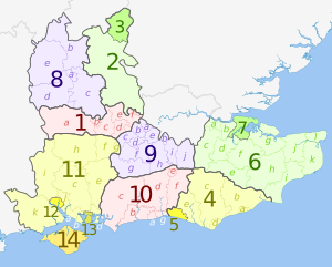
English: Map of the South East region of England, showing its counties and administrative districts since 1 April 2020. The county colours are the same as those in File:English metropolitan and non-metropolitan counties 2009.svg.
Equirectangular map projection on WGS 84 datum, with N/S stretched 160% Geographic limits:
|
| 日期 | |
| 來源 |
本檔案衍生自: South East England counties 2009 map.svg: |
| 作者 |
Key
授權條款
此檔案採用共享創意 姓名標示-相同方式分享 3.0 未在地化版本授權條款。
姓名標示: Dr Greg and Nilfanion. Contains Ordnance Survey data © Crown copyright and database right 2010
- 您可以自由:
- 分享 – 複製、發佈和傳播本作品
- 重新修改 – 創作演繹作品
- 惟需遵照下列條件:
- 姓名標示 – 您必須指名出正確的製作者,和提供授權條款的連結,以及表示是否有對內容上做出變更。您可以用任何合理的方式來行動,但不得以任何方式表明授權條款是對您許可或是由您所使用。
- 相同方式分享 – 如果您利用本素材進行再混合、轉換或創作,您必須基於如同原先的相同或兼容的條款,來分布您的貢獻成品。
檔案歷史
點選日期/時間以檢視該時間的檔案版本。
| 日期/時間 | 縮圖 | 尺寸 | 用戶 | 備註 | |
|---|---|---|---|---|---|
| 目前 | 2023年5月28日 (日) 20:32 | | 1,425 × 1,141(2.28 MB) | Dr Greg | Uploaded a work by * ''South East England counties 2009 map.svg'': Dr Greg and Nilfanion, contains Ordnance Survey data * derivative work: Dr Greg from {{Derived from|South East England counties 2009 map.svg|display=50}} with UploadWizard |
檔案用途
下列頁面有用到此檔案:
全域檔案使用狀況
以下其他 wiki 使用了這個檔案:
- de.wikipedia.org 的使用狀況
- en-two.iwiki.icu 的使用狀況