
File:Stellardiagram-Zhengho.jpg
預覽大小:456 × 599 像素。 其他解析度:183 × 240 像素 | 365 × 480 像素 | 584 × 768 像素 | 779 × 1,024 像素 | 1,385 × 1,820 像素。
原始檔案 (1,385 × 1,820 像素,檔案大小:1.74 MB,MIME 類型:image/jpeg)
摘要
| 作者 |
The author is unknown, but the charts were derived from works by Zheng He's expeditionary navigators during the early 15th century |
| 描述 |
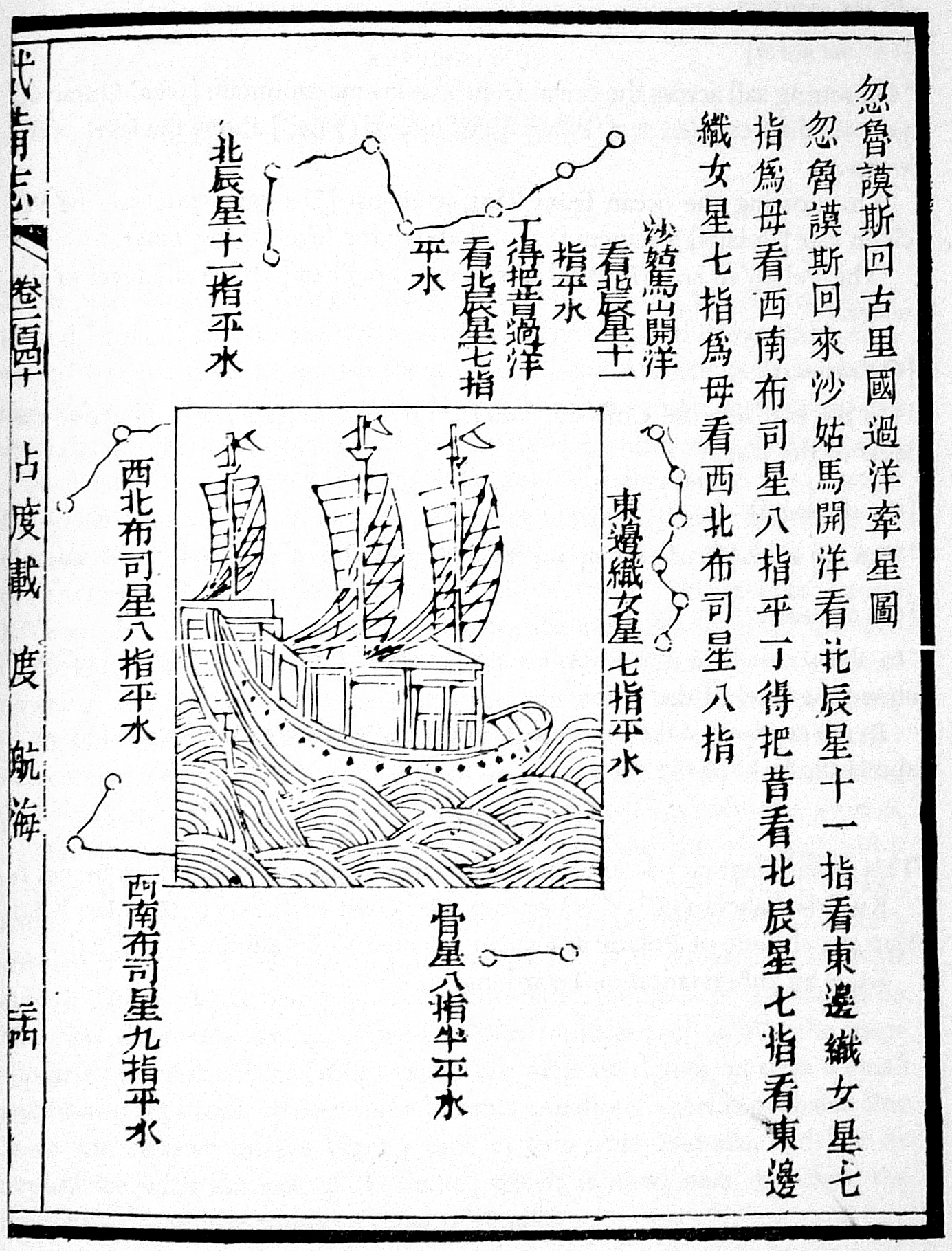
This navigational chart is one of the four stellar diagrams included in the Wubei Zhi, published in circa 1628. It appears in chapter 240, folio 24 r. The chart specifies the guiding stars enroute from Hormuz to Calicut. |
| 來源/攝影者 | Not given by uploader |
| 其他版本 |
|
| Reference | Mills, J.V.G. (1970). Ying-yai Sheng-lan: 'The Overall Survey of the Ocean's Shores' [1433]. pp. 335–346. |

授權條款
|
本作品在其來源國以及其他版權期限是作者逝世後100年或以下的國家與地區屬於公有領域。 | |
| 此作品無已知的著作權限制,亦不受所有相關和鄰接的權利限制。 | |
檔案歷史
點選日期/時間以檢視該時間的檔案版本。
| 日期/時間 | 縮圖 | 尺寸 | 用戶 | 備註 | |
|---|---|---|---|---|---|
| 目前 | 2015年8月1日 (六) 19:32 | | 1,385 × 1,820(1.74 MB) | Hzh | clearer image |
| 2005年12月8日 (四) 15:55 |  | 588 × 800(78 KB) | Gisling | Admiral Zheng Ho's stellar navigation diagram |
檔案用途
全域檔案使用狀況
以下其他 wiki 使用了這個檔案:
- af.wikipedia.org 的使用狀況
- ar.wikipedia.org 的使用狀況
- ca.wikipedia.org 的使用狀況
- cs.wikipedia.org 的使用狀況
- el.wikipedia.org 的使用狀況
- en-two.iwiki.icu 的使用狀況
- es.wikipedia.org 的使用狀況
- fr.wikipedia.org 的使用狀況
- it.wikipedia.org 的使用狀況
- ja-two.iwiki.icu 的使用狀況
- pt.wikipedia.org 的使用狀況
- ru.wikipedia.org 的使用狀況
- sl.wikipedia.org 的使用狀況
- test.wikipedia.org 的使用狀況
- te.wikipedia.org 的使用狀況
- uk.wikipedia.org 的使用狀況
- vi.wikipedia.org 的使用狀況